Archipelago National Park
| Archipelago National Park (Skärgårdshavets nationalpark, Saaristomeren kansallispuisto) | |
| Protected area | |
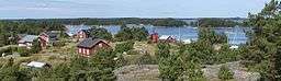 Gullkrona, a village in Nagu, within the national park | |
| Country | Finland |
|---|---|
| Region | Southwest Finland |
| Coordinates | 59°54′53″N 21°52′39″E / 59.91472°N 21.87750°ECoordinates: 59°54′53″N 21°52′39″E / 59.91472°N 21.87750°E |
| Area | 500 km2 (193 sq mi) |
| Established | 1983 |
| Management | Metsähallitus |
| Visitation | 53,500 (2009[1]) |
| IUCN category | II - National Park |
 Location in Finland
| |
| Website: http://www.outdoors.fi/archipelagonp | |
Archipelago National Park (Swedish: Skärgårdshavets nationalpark, Finnish: Saaristomeren kansallispuisto) is a national park in Southwest Finland. It was established in 1983 and covers 500 square kilometres (193 sq mi) of land areas,[2][3] a huge land area considering that the area mostly is outer archipelago with few islands even 1 km2 - and the big ones are inhabited and mostly privately owned and thus not part of the national park. The park's web pages give that number as non-qualified "area". It is part of the UNESCO biosphere reserves and received a PAN Parks certificate in 2007.
The park encompasses all state-owned land and water areas owned by the state within the borders of the cooperation area surrounding the park, which is more or less the entire outer archipelago of the Archipelago Sea on the eastern side of the Åland Islands and south of the Korpo, Nagu, Pargas and Kimitoön main islands.[4] The Archipelago Sea Biosphere reserve consists of the national park's cooperation area and the rest of the islands in the Åboland archipelago only accessible by boat or ferry. These areas are mainly situated in Nagu, Korpo, Houtskär, Iniö, Hitis and southern Pargas.
There are considerable areas of traditional agricultural landscapes within the national park. One of the objectives of national park besides protecting nature is to protect the archipelago culture and different cultural landscapes. The cooperation area plays a great in this. The National park by itself encompasses about 2000 of the 8400 islets and skerries within the cooperation area. The larger islands are mainly owned by their inhabitants.
One may move around freely by boat in the National park, with the exception of some protected areas. Shuttle ships operate the inhabited islands and many entrepreneurs offer transportation by agreement. Camping is allowed only in designated places (allowed on privately own lands in accordance with the freedom to roam), remembering to respect the domestic peace. Building campfires is allowed only in designated places, unless a force majeure situation arise. Fire-making is prohibited if a forest fire warning is in effect. One may pick berries and mushrooms. Mind roosting birds when landing on islets. Islets with many nesting birds should only be visited in autumn and winter. The Blue Mussel visitor center in Kasnäs, (Kimitoön) and the archipelago center in Korpoström (Korpo) offer information on the Archipelago Sea and the Archipelago National park. There are bus connections to both. There are nature trails on some of the islands. There is an underwater trail for divers on Stora Hästö in Korpo (and one in shallower water for snorkelers).[5][6]
History
Man settles in the Archipelago
The archipelago of Southwest Finland has been populated since the neolithic (roughly 2000-1300 BCE). The rich natural resources attracted people to the post-glacial archipelago in the stone and bronze ages. The Baltic Sea was much more saline in those days, thus offering large catches of Atlantic cod among other fish. A large population of grey seal inhabited the area. The humans utilized the rich populations of seabirds as a source of eggs, meat and down. Because of the warmer climate, the conditions for small-scale agriculture and cattle herding were even better than nowadays.[7]
Due to Post-glacial rebound the islands in the Archipelago Sea suitable for habitation have risen from the sea and inhabitants have moved farther out in the archipelago as large enough islands have surfaced. The ground still rises in the Archipelago Sea at a rate of approximately 3-4,2 mm per year.[8] During the Stone Age and the Bronze Age, the islets of the present-day outer archipelago were 20 – 25 metres below the sea level. Then outer archipelago was located around the present main islands of Nagu, Korpo and Houtskär. Nowadays, the Stone Age settlement of Bötesberget in the municipality of Dragsfjärd, from 6000 BCE, is located 55 metres above the sea level, on forested upland. In the old days, the landscape surrounding its inhabitants was quite different from today: the settlement was situated on an isolated island in the middle of large open water areas.[9]
Inside the actual cooperation area of Archipelago National Park, no Stone Age settlements have been found so far, but there are about forty burial mounds from the Bronze Age and Iron Age. Two fort islets from the prehistoric times have also been recognised in the archipelago, possibly dating back to the Iron Age.[9] Trade, handcraft and navigation were practiced already in the early times in addition to the basic sources of livelihood. Sailing began in the whole of the Baltic Sea region latest in the Bronze Age. The southwestern archipelago became a part of the northern Baltic Sea region cultures, which had common means of livelihood, use of metals, and burial customs. The present National Park area became inhabited in the Iron Age (500 BCE-1150 CE). Many ancient remains of the Iron Age settlements have been found in the National Parks cooperation area. Pollen analysis has shown that the agriculture in the coast has been continuous since the Iron Age until these days.[7] The most characteristic antiquities of the archipelago are relics from the historic times, from the end of the Iron Age until the 18th and 19th century. These immovable relics are also protected by the Antiquities Act.[9]
The most impressive relics in the archipelago are the cairns. These cairns have been built during the Bronze Age and the Iron Age from stones which “a man is able to lift”. The size of these barrows varies, the diameter of some low cairns is a few metres, but some are tens of metres long and a couple of metres high. In the beginning of the Bronze Age, dead bodies were buried in these barrows, but later it became the custom to burn the dead body. In some of the graves, there are jewellery or weapons. In others, there are no artefacts, or they have not been preserved. The Finnish folksy name for these cairns translates literally as “Devil’s sauna stove”.[9]
Burial mounds have been found in all parts of the archipelago, on islands of various size. However, most barrows have originally been built on larger islands, which have later become even bigger due to the land uplift. Often the burial sites have been chosen so that they stand out from the surrounding landscape, such as rocky hills or tops of the islands, with a view to the sea. The burial mounds in Archipelago National Park are low and quite small heaps of stones, which have been built near the highest place of the islands, but not on the very top. Some graves are near the shore, and some are organised in groups of several cairns. Most of the burial mounds in Southwestern Archipelago, if not all of them, are from the Iron Age. Inside the cooperation area of Archipelago National Park, most graves have been found on the large islands of Nötö and Hitis. Already in the Iron Age, these areas bristled with islands, from which it was not a long way to go fishing or seal hunting in the outer archipelago. This area, with its favourable natural conditions, may well have been inhabited already in the Iron Age.[9]
The Swedes settle in the archipelago
The Swedish settlers moved to the area from Svealand, southern Norrland and Götaland in the late 13th century, and therefore the population increased remarkably.[8] About half of the villages in the current National Park cooperation area were inhabited already in the Middle Age. The population in the archipelago increased until the mid 16th century, after which it started to decline rapidly. The natural resources could not support more people with the techniques of the time. The decline was caused not only by the decrease in available natural resources but also by wars and diseases. In the beginning of the 18th century the Great Northern War and the Black Death made the life more difficult in the archipelago.[7]
Naturally, many archeological findings in the outer archipelago have something to do with fishing as a source of livelihood. These include “tomtning” remains from the temporary dwellings of the fishermen, tracks for dragging boats across the land, labyrinths, stone stoves, and marks carved onto rocks. “Tomtning” remains are related to overnight shelters or storage constructions built by our ancestors on their seasonal fishing trips. Because their fishing trips were long, shelters were needed in the harsh conditions of the archipelago. The rock walls of these temporary shelters were piled up surrounding level open floors, and they can still be seen today in many places. Sometimes natural formations, such as cliffs, were used as a part of a shelter.[9]
In the municipality of Korpo, on the village island of Jurmo, are some of the most studied antiquities in Southwestern Archipelago: so called monk rings. Interpreting these four stone circles has been tried already in the 18th century, when it was suspected that they were made by monks from the village of Kökar. It has been found that Franciscans really lived on Kökar Island from the end of the 14th century to the 1530s. So it might well be the case that the monks built these stone rings on their fishing trips, for example. Why did they do so, is still not known. One interpretation is that they are remnants of a kind om "tomtning".[9]
In the mid-19th century the life in the outer archipelago changed because the technical development made it easier to earn a living. New fishing methods, such as hook and drift nets, no longer required a joint effort from the whole village. Their deployment made it possible for people to live outside the villages. The new settlements led to fast population growth.[7] In the beginning of the 20th century, the work opportunities in mainland and towns began to attract the people of the archipelago. The poorest crofter’s cottages were deserted first. However, the outer archipelago was still inhabited until the 1950s. Cows, horses and sheep stopped grazing the islands and former fields as a re´sult of the emigration. This led to a gradual forestification of the former fields and meadows and to a decline in the state of the buildings in archipelago.[8] Around the 1970s the population started to grow again as the town people found the “summer paradise”.[7]
Fauna
The fauna of the Archipelago National Park is extraordinary well known due to research and regular follow-ups. Twenty-five species of mammals have been found. The most common ones are: common shrew, pygmy shrew, mountain hare, bank vole, red fox, raccoon dog, mink and moose. The numbers of grey seal av increased in recent years, the ringed seal has decreaed on the other hand. The fish stock is grand and the most common species include baltic herring, european perch, northern pike, common roach, bream, viviparous eelpout, european flounder and fourhorn sculpin.
The National park also harbours a large number of birds. The number of species known to have nested in the national park amount to 132. The most numerous species are :mute swan, great cormorant, mallard, tufted duck, goosander, red-breasted merganser, eurasian oystercatcher, ruddy turnstone, common redshank, common sandpiper, common gull, great black-backed gull, european herring gull, Arctic tern, black guillemot, white wagtail, eurasian rock pipit, meadow pipit, northern wheatear, thrush nightingale, common whitethroat, lesser whitethroat and hooded crow.
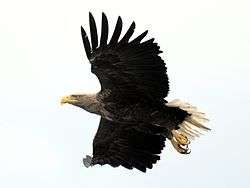
Less common but regular nesting species are horned grebe, greylag goose, barnacle goose, common shelduck, gadwall, northern shoveler, white-tailed eagle, black grouse, ringed plover, northern lapwing, eurasian woodcock, Arctic skua, lesser black-backed gull, caspian tern, common tern, razorbill, eurasian eagle-owl, icterine warbler, barred warbler and common raven. Rare or infrequent species in the park are among others: short-billed dunlin, ruff, little tern, common murre, long-eared owl, short-eared owl.
Removal of mink
The removal of mink from the Archipelago National Park was initiated in the 1990s and many bird species have increased their numbers and experienced improved nesting success as a result. Out of the 22 species of archipelago birds studied, 14 showed an increase in numbers. Some species (tufted duck, velvet scoter, Arctic tern) increased greatly with some showing an increase to a lesser extent.[11] Removal of mink was initiated in the Vänö archipelago in southern Dragsfjärd in 2006. The results show that the nesting success of some species increased greatly and rapidly.[12]
Connections
The main means of transportation in the Archipelago National Park are shuttle ships or boats. There is shuttle ship connection to all of the inhabited islands within the cooperation area. The islands of Holma, Jurmo and Berghamn are accessible by shuttle ship and national park services offered on the islands. The shuttle ship harbours at Prostvik and Pärnäs in Nagu and Kasnäs in Kimitoön are accessible by road and have bus connections. You can reach both the Archipelago visitor centre Blue Mussel and the Korpoström Archipelago centre by car.[13]
Literature
- Miettinen, Mika 1996: Saaristomeren kansallispuiston eteläosan ja eteläisen Selkämeren pesimälinnusto 1993. - Metsähallitus, Vantaa. ISBN 951-53-0865-8 (In Finnish with English abstract)
- Mietinen, Mika; Stjernberg, Torsten & Högmander, Jouko 1997: Breeding bird fauna in the Southwestern Archipelago National Park and in its cooperation area in the beginning of the 1970s and 1990s. - Metsähallitus. Vantaa. ISBN 951-53-1236-1 (In Finnish with English abstract)
See also
References
- ↑ "Käyntimäärät kansallispuistoittain 2009" (in Finnish). Metsähallitus. Retrieved September 29, 2010.
- ↑ Archipelago National Park Archived July 16, 2014, at the Wayback Machine.
- ↑ The National Park is regulated by these Finnish laws: Lag om Skärgårdshavets nationalpark (645/1982) and förordningen om Skärgårdshavets nationalpark (1123/1994) and the national park's rules and regulations
- ↑ Map of the cooperation area
- ↑ "Archived copy". Archived from the original on 2014-07-15. Retrieved 2014-06-10. Archipelago national park rules
- ↑ "Archived copy". Archived from the original on 2014-07-14. Retrieved 2014-06-10. Archipelago national park activities
- 1 2 3 4 5 Archipelago history Archived July 14, 2014, at the Wayback Machine.
- 1 2 3 4 Lindgen, Leif 2000: Island pastures Oy Edita Ab, Helsinki. ISBN 951-37-3272-X
- 1 2 3 4 5 6 7 The Prehistory and the History of the Outer Archipelago Archived July 14, 2014, at the Wayback Machine.
- ↑ Mietinen, Mika; Stjernberg, Torsten & Högmander, Jouko 1997: Breeding bird fauna in the Southwestern Archipelago National Park and in its cooperation area in the beginning of the 1970s and 1990s. - Metsähallitus. Vantaa. ISBN 951-53-1236-1
- ↑ Mikael Nordström's doctoral thesis Archived December 14, 2011, at the Wayback Machine.
- ↑ Ministry of agriculture and forestry/Common interest in natural resources Archived June 6, 2014, at the Wayback Machine.
- ↑ Archipelago directions and maps Archived July 14, 2014, at the Wayback Machine.
External links
| Wikimedia Commons has media related to Southern Archipelago Sea. |