Arizona State Route 99
| ||||
|---|---|---|---|---|
 | ||||
| Route information | ||||
| Maintained by ADOT | ||||
| Length: | 44.31 mi[1] (71.31 km) | |||
| Existed: | 1970 – present | |||
| Major junctions | ||||
| South end: | South of Winslow, road continues as Apache-Sitgreaves National Forest service road 34 | |||
|
| ||||
| North end: |
| |||
| Highway system | ||||
| ||||

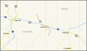
State Route 99 or SR 99 is a 44.31-mile (71.31 km) state highway in the U.S. state of Arizona.
Route description
SR 99 starts in Leupp, Arizona in the Navajo Indian Reservation and heads south to Interstate 40 west of Winslow. Heading into Winslow, State Route 99 runs on a shared insight with I-40, then exiting I-40 in Winslow onto Business Spur 40. In Winslow state route 99 heads south on State Route 87 beginning again south of Winslow where state route 99 separates and heads towards the edge of the Apache Forest where the state maintenance of the road ends.
History
The route was defined by the Arizona Department of Transportation in 1968 as State Route 99.[2][3] A designation of the nearby State Route 377 was deleted in 1983 and added to SR 99.[4] Since then, there have not been any major realignments of the route.
Gallery
-
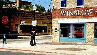
The "standin' on the corner" statue and mural in downtown Winslow commemorates the Eagles' song "Take It Easy". The southbound corridor of State Route 99 (West 2nd Street) is visible in the background.
Major intersections
| County | Location | mi | km | Destinations | Notes |
|---|---|---|---|---|---|
| Navajo | | 0.00 | 0.00 | Forest Service Road 34 (Wallace Road) | Continuation beyond southern terminus |
| | 15.01 | 24.16 | South end of SR 87 concurrency | ||
| Winslow | 16.30 | 26.23 | One-way street; outbound access only | ||
| 16.30 | 26.23 | One-way street; inbound access only; north end of SR 87 concurrency | |||
| South end of I-40 BS concurrency | |||||
| 18.25 | 29.37 | Interchange; north end of I-40 BS concurrency, south end of I-40 concurrency; I-40 exit 252 | |||
| Coconino | | 24.94 | 40.14 | Interchange; north end of I-40 concurrency; I-40 exit 245 | |
| Leupp | 44.31 | 71.31 | Northern terminus | ||
1.000 mi = 1.609 km; 1.000 km = 0.621 mi
| |||||
References
- ↑ Arizona Department of Transportation. "2008 ADOT Highway Log" (PDF). Retrieved 2008-04-09.
- ↑ 1971 Highway Map of Arizona (Section 2) (Map). Arizona Highway Department. § 2. Retrieved February 7, 2011.
- ↑ 1971 Highway Map of Arizona (Section 4) (Map). Arizona Highway Department. § 4. Retrieved February 7, 2011.
- ↑ Arizona Department of Transportation. "Arizona Right-of-Way Resolutions 1968--022 and 1983-15-A-072". Retrieved February 7, 2011.