Arkansas Highway 132
| ||||
|---|---|---|---|---|
| University Blvd | ||||
 | ||||
| Route information | ||||
| Maintained by AHTD | ||||
| Length: | 1.24 mi[1] (2.00 km) | |||
| Existed: | May 14, 1997[2] – present | |||
| Major junctions | ||||
| West end: |
| |||
|
| ||||
| East end: |
| |||
| Location | ||||
| Counties: | Conway | |||
| Highway system | ||||
| ||||

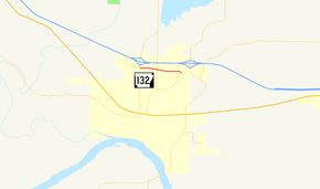
Highway 132 (AR 132, Ark. 132, Hwy. 132, and University Blvd) is an east–west state highway in Morrilton, Conway County, Arkansas. The highway runs 1.24 miles (2.00 km) from Highway 95 east to Highway 9 Business (Hwy. 9B). The route serves as a main arterial street in Morrilton, connecting two major north–south streets to the University of Arkansas Community College at Morrilton (UACCM).
Route description
Highway 132 begins at Highway 95 in western Morrilton, near Interstate 40 (I-40). The route runs east to an intersection with Highway 247, known as Poor Farm Rd within Morrilton. After this intersection, Highway 132 passes along the southern edge of the University of Arkansas Community College at Morrilton (UACCM) campus before intersecting Highway 9B, where it terminates.[3]
History
Highway 132 in Morrilton was added to the state highway system at the request of the city's mayor in 1997. The segment was added as part of an exchange that transferred a former portion of Highway 9B from US Highway 64 (US 64) to Highway 9 to city maintenance.[2]
Major intersections
The entire route is in Morrilton, Conway County.
| mi[3] | km | Destinations | Notes | ||
|---|---|---|---|---|---|
| 0.00 | 0.00 | Western terminus | |||
| 0.49 | 0.79 | ||||
| 1.24 | 2.00 | Eastern terminus | |||
1.000 mi = 1.609 km; 1.000 km = 0.621 mi
| |||||
Former route
| |
|---|---|
| Location: | Magnolia to Louisiana state line |
| Length: | 25 mi (40 km) |
| Existed: | 1928[4]–August 24, 1994[5] |
Highway 132 (AR 132, Ark. 132, and Hwy. 132) was a state highway of approximately 25 miles (40 km) in Columbia County. The route began at US 82 and ran south to the Louisiana state line. The route was created in 1928[4] and replaced by the US 371 designation in 1994.[5]
Initially referenced as the Bi-State Corridor, the Arkansas State Highway Commission designated Highway 132 and several other highways as a proposed corridor to seek American Association of State Highway and Transportation Officials approval as a US Highway in January 1994.[6] Upon receiving approval, the route was officially decommissioned in favor of US 371 on August 24, 1994.[5]
See also
-
 Arkansas portal
 -
 U.S. Roads portal
References
- ↑ System Information and Research Division (2014). "Arkansas Road Log Database" (MDB). Little Rock: Arkansas State Highway and Transportation Department. Retrieved March 27, 2016.
- 1 2 Arkansas State Highway Commission (May 14, 1997). "Minute Order 97-095" (PDF). Minutes of the Meeting. Little Rock: Arkansas State Highway Commission. p. 923. Retrieved April 10, 2016.
- 1 2 Planning and Research Division (January 2, 2008). General Highway Map, Conway County, Arkansas (PDF) (Map). Little Rock: Arkansas State Highway and Transportation Department. Retrieved April 10, 2016.
- 1 2 Arkansas State Highway Department (September 1, 1928). Map of State of Arkansas Showing System of State Highways (Map). 1:500,000. Little Rock: Arkansas State Highway Department.
- 1 2 3 Arkansas State Highway Commission (August 24, 1994). "Minute Order 94-263" (PDF). Minutes of the Meeting. Little Rock: Arkansas State Highway Commission. pp. 470–471. Retrieved April 10, 2016.
- ↑ Arkansas State Highway Commission (January 26, 1994). "Minute Order 94-004" (PDF). Minutes of the Meeting. Little Rock: Arkansas State Highway Commission. pp. 470–471. Retrieved April 10, 2016.