Arkansas Highway 280
| ||||
|---|---|---|---|---|
 | ||||
| Route information | ||||
| Maintained by AHTD | ||||
| Length: | 5.85 mi[1] (9.41 km) | |||
| Existed: | 1963 – present | |||
| Major junctions | ||||
| West end: |
| |||
| East end: |
| |||
| Location | ||||
| Counties: | Greene, Clay | |||
| Highway system | ||||
| ||||

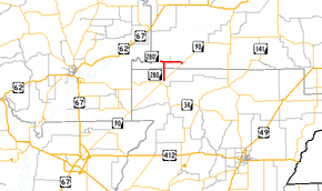
Arkansas Highway 280 is a state highway in Clay and Greene Counties. The route runs 5.85 miles (9.41 km) from Arkansas Highway 90 near Delaplaine north then east to AR 90 in Peach Orchard.[2][3] It does not intersect any other state highways.
Route description
AR 280 begins at AR 90 and heads due north to Brookings. It then turns and heads due east for 3.0 miles (4.8 km) to Peach Orchard, where it terminates at AR 90.[4][5] The highway is located near the Dave Donaldson/Black River Wildlife Management Area.
Major intersections
| County | Location | mi[2][3] | km | Destinations | Notes |
|---|---|---|---|---|---|
| Greene | Delaplaine | 0.0 | 0.0 | western terminus | |
| Clay | Brookings | 2.9 | 4.7 | AR 280S eastern terminus | |
| Peach Orchard | 5.85 | 9.41 | eastern terminus | ||
| 1.000 mi = 1.609 km; 1.000 km = 0.621 mi | |||||
History
The route first became a state highway in 1963.[6] AR 208S/AR 208 from Brookings to AR 90 was paved upon addition to the state highway system.
Brookings spur
| |
|---|---|
| Location: | Brookings |
| Length: | 0.47 mi[1] (0.76 km) |
| Existed: | 1963–present |
Arkansas Highway 280 Spur is a 0.47 miles (0.76 km) spur route to the unincorporated community of Brookings in Clay County.
- Route description
The entire route is in Brookings, Clay County.
| mi[2] | km | Destinations | Notes | ||
|---|---|---|---|---|---|
| 0.0 | 0.0 | eastern terminus | |||
| 0.47 | 0.76 | Black River | western terminus | ||
| 1.000 mi = 1.609 km; 1.000 km = 0.621 mi | |||||
References
- 1 2 "[Arkansas] State Highways 2009 (Database)." April 2010. AHTD: Planning and Research Division. Database. Retrieved March 22, 2011.
- 1 2 3 General Highway Map - Clay County, Arkansas (PDF) (Map) (4/27/07 ed.). Arkansas State Highway and Transportation Department. Retrieved March 22, 2011.
- 1 2 General Highway Map - Greene County, Arkansas (PDF) (Map) (4/27/07 ed.). Arkansas State Highway and Transportation Department. Retrieved March 22, 2011.
- ↑ Arkansas State Highway and Transportation Department. AHTD Clay County map Retrieved on June 12, 2009.
- ↑ Arkansas State Highway and Transportation Department. AHTD Greene County map Retrieved on June 12, 2009.
- ↑ Official Highway Map of Arkansas (Map). Arkansas State Highway Department. Retrieved March 22, 2011.