Arkansas Highway 303
| ||||
|---|---|---|---|---|
 | ||||
| Route information | ||||
| Maintained by AHTD | ||||
| Existed: | April 24, 1963[1] – present | |||
| Section 1 | ||||
| Length: | 1.86 mi[2] (2.99 km) | |||
| South end: |
| |||
| North end: |
| |||
| Section 2 | ||||
| Length: | 9.62 mi[2] (15.48 km) | |||
| South end: |
| |||
| North end: | Benton County line | |||
| Section 3 | ||||
| Length: | 2.27 mi[2] (3.65 km) | |||
| South end: |
| |||
| North end: |
| |||
| Highway system | ||||
| ||||

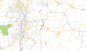
Highway 303 (AR 303, Ark. 303, and Hwy. 303) is a designation for three north–south state highways in northwest Arkansas. A southern route of 1.86 miles (2.99 km) runs north from Lollar's Creek Road (Madison County Road 192 [CR 192]) to Highway 74.[3] A second route of 9.62 miles (15.48 km) begins at Highway 45 at Mayfield and runs north to the Benton County line.[4] A third segment of 2.27 miles (3.65 km) begins at Highway 12 and runs north to Rocky Branch Road near Beaver Lake.[5]
Route description
Madison County
Highway 303 begins at Lollar's Creek Road (Madison CR 192) and runs northwest to terminate at Highway 74 east of Wesley.[3]
Mayfield to Benton County
Highway 303 begins at Highway 45 at Mayfield and runs north through unincorporated Washington County to meet US Route 412 at Spring Valley. The two routes participate in a 1 mile (1.6 km) concurrency east until Highway 303 turns north from US 412 near the Madison County line. The route then runs north towards War Eagle and becomes Benton CR 98 which eventually gives access to Highway 12 near Beaver Lake.[4]
Beaver Lake
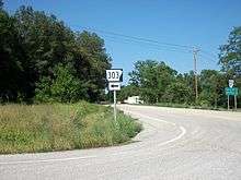
Highway 303 begins at Highway 12, angling northeast before terminating at Rocky Branch Road (Benton CR 99) near Beaver Lake.[5]
History
Highway 303 was added to the state highway system as part of a large transfer of county roads to the state system that took place on April 24, 1963.[1] Initially only the portion from Mayfield to the Benton County line was transferred to state maintenance.
Major intersections
| County | Location | mi[2] | km | Destinations | Notes | ||
|---|---|---|---|---|---|---|---|
| Madison | | 0.00 | 0.00 | Southern terminus | |||
| | 1.86 | 2.99 | Northern terminus | ||||
| Highway 303 begins at Mayfield | |||||||
| Washington | Mayfield | 0.00 | 0.00 | Southern terminus | |||
| Spring Valley | 3.55– 4.59 | 5.71– 7.39 | |||||
| Washington–Benton county line | | 9.62 | 15.48 | Northern terminus, roadway continues as Benton CR 98 | |||
| Highway 303 begins near Beaver Lake | |||||||
| Benton | | 0.00 | 0.00 | Southern terminus | |||
| | 2.27 | 3.65 | Northern terminus | ||||
| 1.000 mi = 1.609 km; 1.000 km = 0.621 mi | |||||||
See also
-
 Arkansas portal
 -
 U.S. Roads portal
References
- 1 2 "Minutes of the Meeting" (PDF). Arkansas State Highway Commission. April 24, 1963. p. 918. Retrieved January 27, 2013.
- 1 2 3 4 Planning and Research Division (2010). "Arkansas Road Log Database". Arkansas State Highway and Transportation Department. Archived from the original (Database) on 23 June 2011. Retrieved June 9, 2011.
- 1 2 General Highway Map, Madison County, Arkansas (PDF) (Map). 1:62500. Cartography by Planning and Research Division. Arkansas State Highway and Transportation Department. March 15, 2010. Retrieved January 27, 2013.
- 1 2 General Highway Map, Washington County, Arkansas (PDF) (Map). 1:62500. Cartography by Planning and Research Division. Arkansas State Highway and Transportation Department. December 13, 2011. Retrieved January 27, 2013.
- 1 2 General Highway Map, Benton County, Arkansas (PDF) (Map). 1:62500. Cartography by Planning and Research Division. Arkansas State Highway and Transportation Department. August 20, 2012. Retrieved January 27, 2013.