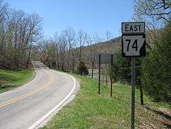
Arkansas Highway 74
| ||||
|---|---|---|---|---|
 | ||||
| Route information | ||||
| Maintained by AHTD | ||||
| Highway system | ||||
| ||||

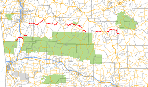
Arkansas Highway 74 (AR 74 and Hwy. 74) is a series of state highways of 103.73 miles (166.94 km) total in Northwest and north central Arkansas and comprises eight separate sections.
The Western most section route begins in Devil's Den State Park at AR 170. The route winding out of the park heading east. AR 74 crosses I-49 at Exit 45 before ending at US 71 in Winslow.
Background
A second segment begins at US 71 just north of Winslow and runs east approximately 2 miles before becoming Washington County Road 43.
Section 3 begins at AR 16 in Elkins, running approximately 20 miles before ending at US 412 BUS in Huntsville
A fourth section begins at AR 23 south of Huntsville, heading east 14 miles before ending at AR 21 in Kingston.
Near Ponca a fifth section begins at AR 43, running east past Lost Valley for a distance of 20 miles, ending at AR 7 in Jasper.
South of Jasper, AR 74 resumes again, passing through unincorporated areas of Newton County. The route meets AR 123 in Piercetown and runs concurrent for 4 miles before splitting off at Mount Judea. From there, it continues 6 more miles to Bass, where it terminates at Cave Rd.
AR 74 begins a seventh section in Snowball at AR 377. The route running 7 miles to meet US 65 north of Marshall.
South of Marshall, AR 74 resumes, following AR 27 for 1 mile before splitting off. It continues another 19 miles before ending at AR 66 east of Thola