Arkansas Highway 91
| ||||
|---|---|---|---|---|
 | ||||
| Route information | ||||
| Maintained by AHTD | ||||
| Length: | 31.91 mi[1] (51.35 km) | |||
| Major junctions | ||||
| South end: |
| |||
| North end: |
| |||
| Highway system | ||||
| ||||

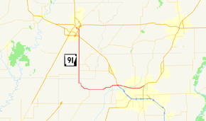
Highway 91 (AR 91, Ark. 91, and Hwy. 91) is a north–south state highway in the Upper Arkansas Delta. The route of 31.91 miles (51.35 km) begins at US Highway 49 (US 49) and Highway 1 at Jonesboro and runs north to US 412 in Walnut Ridge. The route is maintained by the Arkansas State Highway and Transportation Department (AHTD).
Route description
AR 91 begins in northwest Jonesboro at US 63 BUS. The route runs west in a concurrency with AR 18 over US 63 as Dan Avenue. The concurrency continues west as Kings Highway until AR 18 turns south near Dryden. AR 91 meets AR 230 and AR 228 briefly in rural Lawrence County before again crossing US 63. The route continues north to cross US 67 before terminating at US 412 in Walnut Ridge.[2] [3]
Major intersections
| County | Location | mi[1] | km | Destinations | Notes |
|---|---|---|---|---|---|
| Craighead | Jonesboro | 0.00 | 0.00 | Southern terminus | |
| 2.47 | 3.98 | ||||
| 6.74 | 10.85 | Hwy. 18 concurrency begins northbound | |||
| | 8.25 | 13.28 | Hwy. 349 northern terminus | ||
| Three Way | 14.35 | 23.09 | Hwy. 18 concurrency ends | ||
| Lawrence | | 19.83– 20.83 | 31.91– 33.52 | ||
| | 22.35 | 35.97 | Hwy. 228 western terminus | ||
| Walnut Ridge | 29.15 | 46.91 | |||
| 31.91 | 51.35 | Northern terminus | |||
1.000 mi = 1.609 km; 1.000 km = 0.621 mi
| |||||
See also
-
 Arkansas portal
 -
 U.S. Roads portal
References
- 1 2 System Information and Research Division (2014). "Arkansas Road Log Database" (MDB). Arkansas State Highway and Transportation Department. Retrieved March 27, 2016.
- ↑ Transportation Planning & Policy Division (March 23, 2016). General Highway Map, Craighead County, Arkansas (PDF) (Map). 1:62500. Little Rock: Arkansas State Highway and Transportation Department. Retrieved August 13, 2016.
- ↑ Transportation Planning & Policy Division (January 22, 2008). General Highway Map, Lawrence County, Arkansas (PDF) (Map). 1:62500. Little Rock: Arkansas State Highway and Transportation Department. Retrieved August 13, 2016.
This article is issued from Wikipedia - version of the 11/21/2016. The text is available under the Creative Commons Attribution/Share Alike but additional terms may apply for the media files.