Arkansas Highway 92
| ||||
|---|---|---|---|---|
 | ||||
| Route information | ||||
| Maintained by AHTD | ||||
| Length: | 63.4 mi[1][2][3] (102.0 km) | |||
| Major junctions | ||||
| South end: |
| |||
|
| ||||
| North end: |
| |||
| Location | ||||
| Counties: | Conway, Van Buren, Cleburne | |||
| Highway system | ||||
| ||||

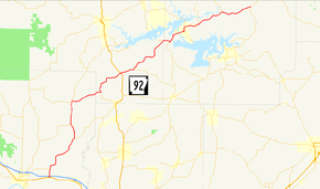
Arkansas Highway 92 is a mostly north–south state highway of 63.4 miles (102.0 km) in north-central Arkansas.[1][2][3]
Route description
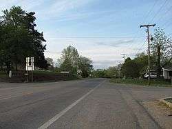
AR 92 begins at US 64 in Plumerville. The route crosses Interstate 40 and continues north through Conway County. A concurrency begins with AR 124 in Springfield and also AR 9 north of Springfield. The AR 9/AR 92/AR 124 concurrency continues north to Center Ridge, when AR 124 turns west, AR 9 heads north, and AR 92 turns east.[1] The highway enters Van Buren County, where it intersects US 65 at Bee Branch and runs near Greers Ferry Lake before entering Cleburne County.[2] The highway continues east to concur with AR 16, cross Greers Ferry Lake, and enter the community of Greers Ferry.[3] Continuing east, AR 92 winds to Drasco, where the route terminates at AR 5/AR 25.
References
- 1 2 3 Arkansas State Highway and Transportation Department. AHTD Conway County map Retrieved on June 24, 2010.
- 1 2 3 Arkansas State Highway and Transportation Department. AHTD Van Buren County map Retrieved on June 24, 2010.
- 1 2 3 Arkansas State Highway and Transportation Department. AHTD Cleburne County map Retrieved on June 24, 2010.