Arkansas Highway 97
| ||||
|---|---|---|---|---|
 | ||||
| Route information | ||||
| Maintained by AHTD | ||||
| Length: | 6.45 mi[1] (10.38 km) | |||
| Existed: | c. 1939-1940[2][3] – present | |||
| Major junctions | ||||
| South end: |
| |||
| North end: |
| |||
| Location | ||||
| Counties: | Cleveland | |||
| Highway system | ||||
| ||||

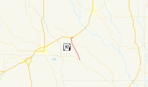
Highway 97 (AR 97, Ark. 97, and Hwy. 97) is a north–south state highway in Cleveland County. The route of 6.45 miles (10.38 km) begins at Highway 8 and runs northwest to US Highway 79 (US 79) in Kingsland. The route is maintained by the Arkansas State Highway and Transportation Department (AHTD).
Route description
The highway begins at Highway 8 in the southwest corner of Cleveland County near New Edinburg at Marks' Mills State Park and a National Historic Landmark. Highway 97 runs northwest toward Kingsland, beginning a concurrency with Highway 189 just south of the city. Once inside the city limits, Highway 189 turns left at 1st Street, ending the concurrency. Highway 97 continues along 1st Street and 3rd Street eastward to a junction with US 79, where it terminates.[4]
History
The highway was added to the state highway system by the Arkansas State Highway Commission between 1939 and 1940 following the completion of a new terrain Highway 8 between New Edinburg and Fordyce. Following completion, the old Highway 8 routing to Kingston was redesignated as Highway 97.[2][3]
Major intersections
The entire route is in Cleveland County.
| Location | mi[1] | km | Destinations | Notes | |
|---|---|---|---|---|---|
| | 0.00 | 0.00 | Southern terminus | ||
| | 5.4 | 8.7 | Begin AR 189 overlap | ||
| Kingsland | 5.9 | 9.5 | End AR 189 overlap | ||
| 6.45 | 10.38 | Northern terminus | |||
| 1.000 mi = 1.609 km; 1.000 km = 0.621 mi | |||||
Former route
| |
|---|---|
| Location: | Lawrence County |
| Existed: | April 1, 1926[5]–c. September 1, 1928[6] |
State Road 97 is a former state highway in Lawrence County.
- History
State Road 97 was created during the 1926 Arkansas state highway numbering as a connector route between State Road 91 and US 79 near Walnut Ridge.[5] The route was deleted from the state highway system by September 1, 1928.[6] This route was eventually supplanted by Highway 91, which switched to the present-day alignment following completion of a new terrain US 63 between Bono and Walnut Ridge.[2]
Major intersections
The entire route was in Lawrence County.
| Location | mi[1] | km | Destinations | Notes | |
|---|---|---|---|---|---|
| | 0 | 0.0 | Southern terminus | ||
| | 2 | 3.2 | Northern terminus | ||
| 1.000 mi = 1.609 km; 1.000 km = 0.621 mi | |||||
See also
-
 Arkansas portal
 -
 U.S. Roads portal
References
- 1 2 3 System Information and Research Division (2014). "Arkansas Road Log Database" (MDB). Arkansas State Highway and Transportation Department. Retrieved March 27, 2016.
- 1 2 3 Arkansas State Highway Commission (1939). Official Highway Map (TIF) (Map). Arkansas State Highway Commission. Retrieved November 22, 2016.
- 1 2 Arkansas State Highway Commission (1940). Official Highway Map (TIF) (Map). Arkansas State Highway Commission. Retrieved November 22, 2016.
- ↑ Arkansas State Highway and Transportation Department (October 9, 2013). General Highway Map, Cleveland County, Arkansas (PDF) (Map). 1:62500. Arkansas State Highway and Transportation Department. Retrieved November 22, 2016.
- 1 2 Arkansas State Highway Commission (April 1, 1926). Map of the State of Arkansas Showing System of State Highways (TIF) (Map). Arkansas State Highway Commission. Retrieved November 22, 2016.
- 1 2 Arkansas State Highway Commission (September 1, 1928). Map of the State of Arkansas Showing System of State Highways (TIF) (Map). Arkansas State Highway Commission. Retrieved November 22, 2016.