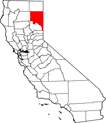
Termo, California
| Termo | |
|---|---|
| Unincorporated community | |
|
Termo  Termo Location in California | |
| Coordinates: 40°51′57″N 120°27′37″W / 40.86583°N 120.46028°WCoordinates: 40°51′57″N 120°27′37″W / 40.86583°N 120.46028°W | |
| Country | United States |
| State | California |
| County | Lassen County |
| Elevation[1] | 5,305 ft (1,617 m) |
Termo (also, Snowstorm and Armstrong)[2] is an unincorporated community in Lassen County, California.[1] It is located on the Southern Pacific Railroad 32 miles (51 km) north-northeast of Susanville,[2] at an elevation of 5305 feet (1617 m).[1] This town straddles U.S. Highway 395 north of Ravendale.
In 1900, Termo was the terminus of the Nevada–California–Oregon Railway.[2] The Termo post office opened in 1908, closed in 1914, and re-opened in 1915.[2]
Termo soils are on lake terraces and in lake basins and have slopes of 0 to 2 percent. The mean annual precipitation is 9 inches (230 mm) and the mean annual temperature is 45 °F (7 °C). The ZIP code is 96132 and the area code 530.
Government
In the California State Legislature, Termo is in the 1st Senate District, represented by Republican Ted Gaines, and in the 1st Assembly District, represented by Republican Brian Dahle.[3]
In the United States House of Representatives, Termo is in California's 1st congressional district, represented by Republican Doug LaMalfa.[4]
References
- 1 2 3 U.S. Geological Survey Geographic Names Information System: Termo, California
- 1 2 3 4 Durham, David L. (1998). California's Geographic Names: A Gazetteer of Historic and Modern Names of the State. Clovis, Calif.: Word Dancer Press. p. 423-424. ISBN 1-884995-14-4.
- ↑ "Statewide Database". UC Regents. Retrieved January 12, 2015.
- ↑ "California's 1st Congressional District - Representatives & District Map". Civic Impulse, LLC. Retrieved March 3, 2013.
