Arnside
| Arnside | |
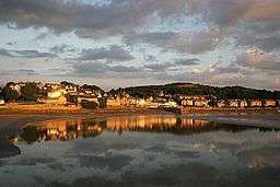 Arnside on the River Kent |
|
 Arnside |
|
| Population | 2,334 (2011) |
|---|---|
| OS grid reference | SD4578 |
| Civil parish | Arnside |
| District | South Lakeland |
| Shire county | Cumbria |
| Region | North West |
| Country | England |
| Sovereign state | United Kingdom |
| Post town | CARNFORTH |
| Postcode district | LA5 |
| Dialling code | 01524 |
| Police | Cumbria |
| Fire | Cumbria |
| Ambulance | North West |
| EU Parliament | North West England |
| UK Parliament | Westmorland and Lonsdale |
Coordinates: 54°11′56″N 2°49′55″W / 54.199°N 2.832°W
Arnside is a village and civil parish in Cumbria, England. It faces the estuary of the River Kent on the north-eastern corner of Morecambe Bay, within the Arnside and Silverdale Area of Outstanding Natural Beauty. Historically it lay within Westmorland, near the border with Lancashire, and has a population of 2,301,[1] increasing to 2,334 at the 2011 Census.[2]
The village lies on the railway line from Lancaster to West Cumbria, which passes over the River Kent via the Arnside viaduct. Up to the 19th century, the village was a port, but building the viaduct caused the estuary to silt up.
The oldest building in the parish is Arnside Tower, a Peel tower built in the 14th/15th century as a refuge against raids from Scots and the Border Reivers. The town is overlooked by Arnside Knott, a hill that rises out of the estuary.
Arnside Golf Club (now defunct) was founded in 1906/7. The club disappeared in the 1920s.[3]
Governance
The village is in the electoral ward of Arnside and Beetham. This ward had a total population of 4,118 at the 2011 Census.[4]
Transport

Arnside railway station, which serves the village, is located on the Furness Line giving connections to Barrow-in-Furness, Ulverston, Grange-over-Sands, Carnforth and Lancaster.
The line was opened in 1857 by the Ulverston and Lancaster Railway, which was taken over by the Furness Railway 26 May 1862. The Furness Railway's Hincaster Branch ran from 26 June 1876, connecting to the Lancaster and Carlisle Railway at Hincaster, which is now part of the West Coast Main Line (WCML). Passenger services ended on the branch on 4 May 1942 and the lines were removed in 1966.
The village is connected to Kendal by the 551 and 552 bus services.
Arnside viaduct
The railway line is carried over the River Kent on a viaduct 552 yards (505 m) long, with 50 piers. It was built in 1857 and rebuilt in 1915.[5]
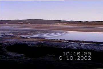
Tides
 |
| This video size: 360x240 500 kbit/s |
| Alternative size: 720x480 2000 kbit/s |
With each high tide, the coast of Arnside is subjected to a very fast rising tide. Because of the potential danger warning notices are posted at the pier, and an audible warning is sounded before every high tide (in daylight). The sequence of warnings is:-
- Eight sounds on the siren - around 2.25 h before high tide
- Eight sounds on the siren - around 1.75 h before high tide
- Twelve sounds on the siren - around 1.25 h before high tide when the incoming tide is just visible from the Coastguard station (location of the siren 54°11′56″N 2°50′28″W / 54.199°N 2.841°W )
The cause of this fast tide is a combination of the large area of Morecambe Bay, which narrows rapidly at Arnside, plus the second highest tidal range (at Barrow-in-Furness, which can be as much as 32 feet (9.8 m) on a spring tide nearest the spring and autumn equinox: these typically give rise to a tidal bore, which may be as high as 12 inches (30 cm), and are often used by canoeists.[6]
See also
Image gallery
-
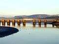
Railway viaduct over the Kent estuary near Arnside
References
- ↑ Office for National Statistics: Census 2001 : Parish Headcounts : South Lakeland Retrieved 3 November 2010
- ↑ "Parish population 2011". Retrieved 9 June 2015.
- ↑ “Arnside Golf Club”, “Golf’s Missing Links”.
- ↑ "Ward population 2011". Retrieved 9 June 2015.
- ↑ "Arnside station and viaduct". VisitCumbria.com. Retrieved 18 April 2013.
- ↑ "Archived copy". Archived from the original on 2011-09-11. Retrieved 2009-01-13.
External links
| Wikimedia Commons has media related to Arnside. |
- Arnside Gateway - local on-line resources
- Arnside Photos Photos of Arnside
- On an 1862 "6 inch" map. This is from the Ordnance Survey of Westmorland. (The view on the 1848-1850 map of Lancashire and Furness is misleading - it was outside the surveyors' area and they have left it as an outline only.)
 |
Lake District National Park | Kendal | | |
| Grange-over-Sands | |
Storth | ||
| ||||
| | ||||
| Silverdale, Morecambe Bay |
Cumbria Portal | |
| Boroughs or districts | |
| Major settlements |
|
| Topics | |