Arroio do Só
| Arroio do Só | |
|---|---|
| Bairro | |
 The bairro in District of Arroio do Só | |
 District of Arroio do Só, in Santa Maria City, Rio Grande do Sul, Brazil | |
| Coordinates: 29°47′31.61″S 53°33′58.78″W / 29.7921139°S 53.5663278°WCoordinates: 29°47′31.61″S 53°33′58.78″W / 29.7921139°S 53.5663278°W | |
| Country | Brazil |
| State | Rio Grande do Sul |
| Municipality/City | Santa Maria |
| District | District of Arroio do Só |
| Area | |
| • Total | 159.30 km2 (61.51 sq mi) |
| Population [1] | |
| • Total | 944 |
| • Density | 5.9/km2 (15/sq mi) |
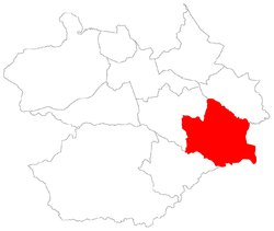
| Adjacent bairros | Palma, Pains, Passo do Verde. |
| Website | Official site of Santa Maria |
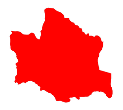
Arroio do Só[2] ("rivulet of the hermit") is a bairro in the District of Arroio do Só in the municipality of Santa Maria, in the Brazilian state of Rio Grande do Sul. It is located in east Santa Maria.
Villages
The bairro contains the following villages: Água Boa, Alto dos Mários, Arroio do Só, Coitado, Parada João Alberti, Picada do Arenal, Rincão dos Becos, Rincão dos Pires, Rincão Nossa Senhora Aparecida, São Geraldo, Tronqueiras, Vila Arroio do Só and Vila Silva.
 |
Pains | Palma | Palma Restinga Seca |
|
| Pains | |
Restinga Seca | ||
| ||||
| | ||||
| Passo do Verde | Passo do Verde / Formigueiro | Restinga Seca Formigueiro |
References
This article is issued from Wikipedia - version of the 12/10/2015. The text is available under the Creative Commons Attribution/Share Alike but additional terms may apply for the media files.