Arugam Bay
| Arugam Bay | |
|---|---|
| Town | |
|
Beach of Arugam Bay | |
 Arugam Bay | |
| Coordinates: 6°51′N 81°50′E / 6.850°N 81.833°ECoordinates: 6°51′N 81°50′E / 6.850°N 81.833°E |


Arugam Bay is a bay situated on the Indian Ocean in the dry zone of Sri Lanka's southeast coast. The bay is located 320 kilometres (200 mi) due east of Colombo, and approximately 4 kilometres (2.5 mi) south of the market town of Pottuvil. The main settlement in the area, known locally as Ullae, is predominantly Muslim,[1] however there is a significant Tamil and Sinhala population to the south of the village, as well as a number of international migrants, largely from Europe and Australia. While traditionally fishing has dominated the local economy, tourism has grown rapidly in the area in recent years. Tourism in Arugam Bay is dominated by surf tourism, thanks to several quality breaks in the area, however tourists are also attracted by the local beaches, lagoons, historic temples and the nearby Kumana National Park.
History
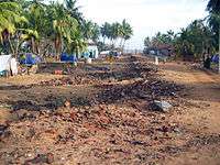
Many of the buildings were destroyed in the 2004 tsunami. The Government's Ministry of Defense CCD (Coastal Conservation Department) created what is now described as Arugam's second "Tsunami" at the end September 2011 when all beach side structures were demolished by bulldozers. Due to its popularity among tourists, the area has managed a slow recovery by private initiatives only. As late as 2011 no help has been received from any official source or international organizations. An exception is uncoordinated support for fishing folk as well as many school rebuilding programs, resulting in a continuation to provide only separatist schools for each community. Although there is a huge demand for an international school, one huge new building donated by the people of Japan remains largely unoccupied since the grand 'opening' ceremony in 2007.
The bay hosts a large fleet of fishing boats which operates off the beach. Many organizations donated boats after the tsunami and as a result there are far more fishing boats than ever before. The main beach is a bit dirty, compared to nearby beaches which are rather more aesthetically pleasing and also have excellent waves.
Development
Many organizations claim to have done extensive work in the area. No notable progress can be observed locally and on close inspection, as late as New Year's Day, 2010. The main road, shown below in 2004 still looked the very same at the end of 2009. Despite calls for a walking street contractors have recently (September, 2010)completed construction of a fast trunk road through the hamlet. Repeating the mistakes made in other seaside tourist resorts such as Negombo and Hikkaduwa. US 'Mercy Corps' has been the most active of any organization. Funded by Oprah Winfrey's 'Angel Network', following a huge fund-raising TV series in the United States. Sadly, none of their projects survived the first year of operation. A new bridge has been constructed by USAID. It was opened for traffic in 2008. It replaced the 1960s, original landmark box girder construction linking Arugam Bay with Pottuvil. At the 312km mark on the main A4 (the famous Colombo High Level Rd. - PottuVille), an excellent shortcut side road exists, which ends up in the very middle of Arugam Bay itself. This picturesque drive avoids the dusty town of Pottuvil Also no bridges need to be crossed.
The more long lasting development efforts have been carried out by a consortium of two Italian NGOs, 'ICEI' and 'Overseas', which are the only development agencies still present in 2013 in the area, working on responsible tourism and sustainable agriculture. As a legacy for the work carried out by these two NGO, a local organization, acting as a social business, has been established: Ecowave. Ecowave is currently managing an outlet in the main street of Arugam Bay, providing market opportunities to the farmers, and offering community tourism itineraries for travelers.
Surfing
The Arugam Bay area is home to a number of quality surf breaks, the most popular of which being 'Main Point' located towards the south of the bay. This is a right hand point break, with a rock/reef bottom, and has a number of sections with occasional barrels. Other breaks in the area include Whiskey Point and Pottuvil Point to the north, and Elephant Rock, Peanut Farm and Okanda to the south. These breaks have attracted a steady stream of international tourists for several decades. Arugam Bay has a good local surf scene and is home to some of Sri Lanka's most talented surfers and in recent years surfers from Arugam Bay have dominated national competitions.[2] In mid-2010 the Association of Surfing Professionals hosted its first international surf contest in the Bay. The winner of such was Australian Julian Wilson . ASP repeated their contest tour in 2011 added a women's competition to the men's long board championship at Arugam Bay.
Surrounding areas
The nearby (4 kilometres (2.5 mi)) Muslim village of Pottuvil is the center of commerce and transportation while tourist accommodations lie along the beach to the south of Pottuvil Arugam Bay (4 kilometres (2.5 mi)) is also the gateway and the only road access to the Yala East National Park. In 2.2 kilometres (1.4 mi) distance there is Pasarichenai Beach. This area is known as Kumana (44 kilometres (27 mi)), to be reached via the Sinhalese settlement of Panama (17 kilometres (11 mi)) and the shires at Okanda (32 kilometres (20 mi)). The local area is home to a number of elephants, often travelling between Lahugala and Kumana national parks.
References
External links
| Wikivoyage has a travel guide for Arugam Bay. |