Assisted GPS
Assisted GPS (abbreviated generally as A-GPS and less commonly as aGPS) is a system that often significantly improves startup performance—i.e., time-to-first-fix (TTFF), of a GPS satellite-based positioning system. A-GPS is extensively used with GPS-capable cellular phones, as its development was accelerated by the U.S. FCC's 911 requirement to make cell phone location data available to emergency call dispatchers.[1]
Description
Standalone/self-ruling GPS devices depend solely on information from satellites. A-GPS augments that by using cell tower data to enhance quality and precision when in poor satellite signal conditions. In exceptionally poor signal conditions, for example in urban areas, satellite signals may exhibit multipath propagation where signals skip off structures, or are weakened by meteorological conditions or tree canopy. Some standalone GPS navigators used in poor conditions can't fix a position because of satellite signal fracture, and must wait for better satellite reception. A GPS unit may need as long as 12.5 minutes (the time needed to download the GPS almanac and ephemerides) to resolve the problem and be able to provide a correct location.[2]
An assisted GPS system can address these problems by using external data. Utilizing this system can come at a cost to the user. For billing purposes, network providers often count this as a data access, which can cost money depending on the plan.[3]
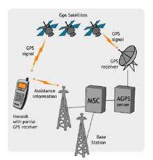
To be precise, A-GPS features depend mostly on an internet network or connection to an ISP (or CNP, in the case of CP/mobile-phone device linked to a Cellular Network Provider data service). A mobile (cell phone, smart phone) device with just an L1 front-end radio receiver and no GPS acquisition, tracking, and positioning engine only works when it has an internet connection to an ISP/CNP where the position fix is calculated offboard the device itself. It doesn't work in areas with no coverage or internet link (or nearby BTS towers, in the case on CNP service coverage area). Without one of those resources, it can't connect to the A-GPS servers usually provided by CNPs. On the other hand, a mobile device with a GPS chipset requires no data connection to capture and process GPS data into a position solution, since it receives data directly from the GPS satellites and is able to calculate a position fix itself. However the availability of a data connection can provide assistance to improve the performance of the GPS chip on the mobile device.
Assistance falls into two categories:
- Mobile Station Based (MSB): Information used to acquire satellites more quickly.
- It can supply orbital data or almanac for the GPS satellites to the GPS receiver, enabling the GPS receiver to lock to the satellites more rapidly in some cases.
- The network can provide precise time.
- Mobile Station Assisted (MSA): Calculation of position by the server using information from the GPS receiver.
- The device captures a snapshot of the GPS signal, with approximate time, for the server to later process into a position.
- The assistance server has a good satellite signal, and plentiful computation power, so it can compare fragmentary signals relayed to it.
- Accurate, surveyed coordinates for the cell site towers allow better knowledge of local ionospheric conditions and other conditions affecting the GPS signal than the GPS receiver alone, enabling more precise calculation of position.
As an additional benefit, in mobile station assisted implementations, the amount of processing and software required for a GPS receiver can be reduced by offloading most of the work onto the assistance server.
A typical A-GPS-enabled receiver uses a data connection (Internet or other) to contact the assistance server for aGPS information. If it also has functioning autonomous GPS, it may use standalone GPS, which is sometimes slower on time to first fix, but does not depend on the network, and therefore can work beyond network range, and without incurring data usage fees.[3] Some A-GPS devices do not have the option of falling back to standalone or autonomous GPS.
Many mobile phones combine A-GPS and other location services including Wi-Fi Positioning System and cell-site multilateration and sometimes a hybrid positioning system.[4]
High Sensitivity GPS is an allied technology that addresses some of these issues in a way that does not require additional infrastructure. However, unlike some forms of A-GPS, high-sensitivity GPS cannot provide a fix instantaneously when the GPS receiver has been off for some time.
Basic concepts
Standalone GPS provides first position in approximately 30–40 seconds. A standalone GPS needs orbital information of the satellites to calculate the current position. The data rate of the satellite signal is only 50 bit/s, so downloading orbital information like ephemerides and the almanac directly from satellites typically takes a long time, and if the satellite signals are lost during the acquisition of this information, it is discarded and the standalone system has to start from scratch. In A-GPS, the network operator deploys an A-GPS server. These A-GPS servers download the orbital information from the satellite and store it in the database. An A-GPS capable device can connect to these servers and download this information using mobile network radio bearers such as GSM, CDMA, WCDMA, LTE or even using other wireless radio bearers such as Wi-Fi. Usually the data rate of these bearers is high, hence downloading orbital information takes less time.
Modes of operation
A-GPS has two modes of operation:
- Mobile Station Assisted (MSA)
- In MSA mode A-GPS operation, the A-GPS capable device receives acquisition assistance, reference time and other optional assistance data from a mobile service provider. The mobile service provider continuously logs GPS information (mainly the almanac) from the GPS satellites using an A-GPS server in its system. With the help of the above data (the data received from the mobile device and the data already present in A-GPS server) the A-GPS server calculates the position and sends it back to the A-GPS device.
- Mobile Station Based (MSB)
- In MSB mode A-GPS operation, the A-GPS device receives ephemeris, reference location, reference time and other optional assistance data from the A-GPS server. With the help of the above data, the A-GPS device receives signals from the visible satellites and calculates the position.[5]
Standards
A-GPS protocols are part of Positioning Protocol defined by two different standardization bodies, 3GPP and Open Mobile Alliance (OMA).
- Control Plane Protocol
- It is defined by 3GPP for various generations of mobile phone system. These protocols are defined for Circuit Switched Networks. Following positioning protocol has been defined.
- RRLP – 3GPP defined RRLP or Radio resource location protocol to support positioning protocol on GSM networks.
- TIA 801 – CDMA2000 family defined this protocol for CDMA 2000 networks.
- RRC position protocol – 3GPP defined this protocol as part of the RRC standard for UMTS network.
- LPP – 3GPP defined LPP or LTE positioning protocol for LTE Networks.
- User Plane Protocol
It is defined by OMA to support positioning protocols in Packet Switched Networks. Two generations of User plane Protocol have evolved.
- SUPL V1.0
- SUPL V2.0
See also
References
- ↑ "Assisted GPS: A Low-Infrastructure Approach". GPS World. March 1, 2002. Retrieved 11 June 2008.
- ↑ NavCen GPS User. 3.5.3 Almanac Collection
- 1 2 Watch out for data charges on a GPS phone. CNET, August 2007
- ↑ Networking iPhone A-GPS Hybrid system
- ↑ http://www.wpcentral.com/gps-vs-agps-quick-tutorial
External links
GPS assisted with Indoor Location Technologies