Geocaching
 International Geocaching Logo[1] | |
| Nicknames | Caching, Treasure Hunting |
|---|---|
| First played | May 3, 2000 |
| Clubs | Yes |
| Characteristics | |
| Team members | Optional |
| Type | Outdoor Recreation Activity |
| Equipment | GPS receiver or GPS-enabled mobile device, writing implement |
Geocaching /ˈdʒiːoʊˌkæʃɪŋ/ is an outdoor recreational activity, in which participants use a Global Positioning System (GPS) receiver or mobile device and other navigational techniques to hide and seek containers, called "geocaches" or "caches", at specific locations marked by coordinates all over the world.
A typical cache is a small waterproof container containing a logbook (with a pen or pencil). The geocacher enters the date they found it and signs it with their established code name. After signing the log, the cache must be placed back exactly where the person found it. Larger containers such as plastic storage containers (Tupperware or similar) or ammunition boxes can also contain items for trading, such as toys or trinkets, usually of more sentimental worth than financial. Geocaching shares many aspects with benchmarking, trigpointing, orienteering, treasure-hunting, letterboxing, and waymarking.
History


Geocaching was originally similar to the 160-year-old game letterboxing, which uses clues and references to landmarks embedded in stories. Geocaching was conceived shortly after the removal of Selective Availability from the Global Positioning System on May 2, 2000, because the improved accuracy[2] of the system allowed for a small container to be specifically placed and located. The first documented placement of a GPS-located cache took place on May 3, 2000, by Dave Ulmer of Beavercreek, Oregon.[3] The location was posted on the Usenet newsgroup sci.geo.satellite-nav[4][5] as 45°17.460′N 122°24.800′W / 45.291000°N 122.413333°W. By May 6, 2000, it had been found twice and logged once (by Mike Teague of Vancouver, Washington). According to Dave Ulmer's message, this cache was a black plastic bucket that was partially buried and contained software, videos, books, food, money, and a slingshot.[5] A geocache and plaque called the Original Stash Tribute Plaque[6] now sit at the site.
The activity was originally referred to as GPS stash hunt or gpsstashing. This was changed shortly after the original hide when it was suggested in the gpsstash eGroup that "stash" could have negative connotations and the term geocaching was adopted.[7]
Over time, a variety of different hide-and-seek-type activities have been created or abandoned, so that "geocaching" now may refer to hiding and seeking containers, or locations or information without containers.[8]
An independent accounting of the early history documents several controversial actions taken by Irish and Grounded, Inc., a predecessor to Groundspeak, to increase "commercialization and monopolistic control over the hobby".[9] More recently, other similar hobbies such as Munzee have attracted some geocachers by rapidly adopting smart-phone technology, which has caused "some resistance from geocaching organizers about placing caches along with munzees".[10]
Geocaches
For the traditional geocache, a geocacher will place a waterproof container containing a log book (with pen or pencil) and trade items or trackables, then record the cache's coordinates. These coordinates, along with other details of the location, are posted on a listing site (see list of some sites below). Other geocachers obtain the coordinates from that listing site and seek out the cache using their GPS handheld receivers. The finding geocachers record their exploits in the logbook and online, but then must return the cache to the same coordinates so that other geocachers may find it. Geocachers are free to take objects (except the logbook, pencil, or stamp) from the cache in exchange for leaving something of similar or higher value.
Typical cache "treasures", also known in the geocaching world as swag, are not high in monetary value but may hold personal value to the finder.[11] Aside from the logbook, common cache contents are unusual coins or currency, small toys, ornamental buttons, CDs, or books. Although not required, many geocachers decide to leave behind signature items, such as personal Geocoins, pins, or craft items, to mark their presence at the cache location.[11] Disposable cameras are popular as they allow for anyone who found the cache to take a picture which can be developed and uploaded to a Geocaching web site listed below.[12] Also common are objects that are moved from cache to cache called "hitchhikers", such as Travel Bugs or Geocoins, whose travels may be logged and followed online. Cachers who initially place a Travel Bug or Geocoins often assign specific goals for their trackable items. Examples of goals are to be placed in a certain cache a long distance from home, or to travel to a certain country, or to travel faster and farther than other hitchhikers in a race. Less common trends are site-specific information pages about the historic significance of the site, types of trees, birds in the area or other such information. Higher-value items are occasionally included in geocaches as a reward for the First to Find (called "FTF"), or in locations which are harder to reach. Dangerous or illegal items, weapons, food and drugs are not allowed and are specifically against the rules of most geocache listing sites.
If a geocache has been vandalized or stolen, it is said to have been "muggled". The former term plays off the fact that those not familiar with geocaching are called muggles, a term borrowed from the Harry Potter series of books which was rising in popularity at the same time geocaching got its start.[13]
Variations
Traditional geocaching gave birth to GeoCaching – an active urban game of the Encounter project. The game is quite similar to geocaching but has time limitations and hints.
Geocaches vary in size, difficulty, and location. Simple caches are often called "drive-bys", "park 'n grabs" (PNGs), or "cache and dash". Geocaches may also be complex, involving lengthy searches or significant travel. Different geocaching websites list different variations per their own policies.
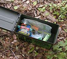
Container sizes range from "nanos", which can be smaller than the tip of finger and have only enough room to store the log sheet, to 20-liter (5 gallon) buckets or even larger containers, such as entire trucks.[14] The most common cache containers in rural areas are lunch-box-sized plastic storage containers or surplus military ammunition cans. Ammo cans are considered the gold standard of containers because they are very sturdy, waterproof, animal- and fire-resistant, relatively cheap, and have plenty of room for trade items. Smaller containers are more common in urban areas because they can be more easily hidden.
Caches can be grouped in three categories – with and without a paper log, and events.
The following types do not have paper logs. Similar to Munzee, a BIT Cache is a laminated card with a QR code, URL and a password needed for logging. More information is available at bitcaching.com.[15] They are listed exclusively on opencaching.us.[16][17][18]
Virtual caches are coordinates for a location, which has some other described object. Validation for finding a virtual cache generally requires one to email the cache hider with information such as a date or a name on a plaque, or to post a picture of oneself at the site with GPS receiver in hand.[19] New virtual caches are no longer allowed by Groundspeak,[20] but they remain supported by other sites.[17]
Earthcaches are virtual caches that are organized by the Geological Society of America. The cacher usually has to perform a task which teaches him/her an educational lesson about the earth science of the cache area.[19]
Locationless/Reverse caches are similar to a scavenger hunt. A description is given for something to find, such as a one-room schoolhouse, and the finder locates an example of this object. The finder records the location using their GPS receiver and often takes a picture at the location showing the named object and his or her GPS receiver. Typically others are not allowed to log that same location as a find.
Webcam caches are virtual caches whose coordinates have a public webcam. The finder is often required to capture their image from the webcam for verification of the find.[19] New webcam caches are no longer allowed by Groundspeak,[20] but they remain supported by other sites.[17] Finally, a USB Cache or Dead Drop cache[17] location has a USB drive embedded (with permission) into walls or other structures. The cache is retrieved by connecting a device that has a USB port and that is able to read standard text files.
The following types have logs, at least at the final location.
A Multi-cache consists of multiple discoveries of one or more intermediate points containing the coordinates for the next stage; the final stage contains the log book. An Offset cache is a multi-cache in which the initial coordinates are for a location containing information that encodes the final cache coordinates. An example would be to direct the finder to a plaque where the digits of a date on the plaque correspond to coordinates of the final cache.[19]
A Night Cache is multi-stage and intended to be found at night by following a series of reflectors with a flashlight to the final cache location.[21]
A Chirp Cache is a Garmin-created innovative advance on multi caches using new wireless beacon technology. The Chirp stores hints, multicache coordinates, counts visitors and confirms the cache is nearby.[22][23] These caches were fully supported at Opencaching.com, but they caused considerable discussion and some controversy at Groundspeak, where they were given a new "attribute".[19][24]
A Wherigo cache is a multi-stage cache hunt that uses a Wherigo "cartridge" to guide the player to find a physical cache sometime during cartridge play, usually at the end. Not all Wherigo cartridges incorporate geocaches into game play. Wherigo caches are unique to the geocaching.com website.[19]
Guest Book Caches use guest books often found in museums, tourist information centers, etc. They are listed exclusively at Opencaching.us.[17]
A Letterbox Hybrid Cache is a combination of a geocache and a letterbox in the same container. A letterbox has a rubber stamp and a logbook instead of tradable items. Letterboxers carry their own stamp with them, to stamp the letterbox's log book and inversely stamp their personal log book with the letterbox stamp. The hybrid cache contains the important materials for this and may or may not include trade items. Whether the letterbox hybrid contains trade items is up to the owner.[19]
Moving/Travelling caches are found at a listed set of coordinates. The finder hides the cache in a different location, and updates the listing, essentially becomes the hider, and the next finder continues the cycle. This cache type is supported by multiple sites.[17]
Mystery/puzzle caches require one to discover information or solve a puzzle to find the cache. Some mystery caches provide a false set of coordinates with a puzzle that must be solved to determine the final cache location. In other cases, the given location is accurate, but the name of the location or other features are themselves a puzzle leading to the final cache. Alternatively, additional information is necessary to complete the find, such as a padlock combination to access the cache.[19] Finally, Challenge Caches, (a subtype of the Mystery cache) require a geocacher to complete a reasonably attainable geocaching-related task before being able to log the find. Examples include finding a number of caches that meet a category, completing a number of cache finds within a period of time, or finding a cache for every calendar day, etc.[19]
There are a few kinds of events. An Event Cache is a gathering organized and attended by geocachers.[19]
Cache-In Trash-Out (CITO) Events are coordinated activities of trash pickup and other maintenance tasks (such as constructing footpaths, planting trees and removing invasive species) to improve the environment.[19] CITO is an ongoing environmental initiative created by Groundspeak Inc. related to geocaching which encourages geocachers to clean up areas parks and other areas.[25] This is done in two ways: specific events, traditionally around the time of Earth Day each year,[26] in which groups go around picking up litter and maintaining the landscape while finding geocaches.[27]
A Mega Event is defined by attendance of over 500 people. Mega Events are typically annual events, usually attracting geocachers from all over the world.[19]
A rare Giga Event is an event with an attendance of over 5000 people, also attracting geocachers from worldwide.[19]
Finally, a GPS Adventures Maze Exhibit is an exhibit at various museums and science centers in which participants in the maze learn about geocaching. These "events" have their own cache type on Geocaching.com and include many non-geocachers.[19]
Geodashing
Geodashing is an outdoor sport in which teams of players use GPS receivers to find and visit randomly selected "dashpoints" (also called "waypoints") around the world and report what they find. The objective is to visit as many dashpoints as possible.[28][29]
Unlike geocaching, nothing is to be left at the dashpoints; the sole objective is to visit them within the time limit.[30][31]
The first game organized by gpsgames.org[32] ran for two months (June and July 2001); each subsequent game has run for one month. Players are often encouraged to take pictures at the dashpoints and upload them to the site.
Geohashing
See geohashing.
A comparable principle underlies geohashing, invented by Randall Munroe, creator of webcomic xkcd.
Stratocaching
Geocaching from space is a combination of flight to near space, the geocaching game, and a unique science experiment. The first Stratocaching event was held on 16 November 2013 in Prague and was successful. Ten caches and two "radioseeds" went up to 30 km (19 mi) into the stratosphere on a gondola called Dropion module carried by a high-altitude balloon. The caches and seeds then fell to earth for people to find.[33][34][35]
Technology
Obtaining data
GPX files containing information such as a cache description and information about recent visitors to the cache are available from various listing sites. Geocachers may upload geocache data (also known as waypoints) from various websites in various formats, most commonly in file-type GPX, which uses XML.[36] Some websites allow geocachers to search (build queries) for multiple caches within a geographic area based on criteria such as ZIP code or coordinates, downloading the results as an email attachment on a schedule. In recent years, Android and iPhone users have been able to download apps such as GeoBeagle[37] that allow them to use their 3G and GPS-enabled devices to actively search for and download new caches.[38][39]
Converting and filtering data
A variety of geocaching applications are available for geocache data management, file-type translation, and personalization. Geocaching software can assign special icons or search (filter) for caches based on certain criteria (e.g. distance from an assigned point, difficulty, date last found).
Paperless geocaching means hunting a geocache without a physical printout of the cache description. Traditionally, this means that the seeker has an electronic means of viewing the cache information in the field, such as pre-downloading the information to a PDA or other electronic device. Various applications are able to directly upload and read GPX files without further conversion. Newer GPS devices released by Garmin, DeLorme and Magellan have the ability to read GPX files directly, thus eliminating the need for a PDA.[40] Other methods include viewing real-time information on a portable computer with internet access or with a web-enabled smart phone. The latest advancement of this practice involves installing dedicated applications on a smart phone with a built-in GPS receiver. Seekers can search for and download caches in their immediate vicinity directly to the application and use the on-board GPS receiver to find the cache.
A more controversial version of paperless caching involves mass-downloading only the coordinates and cache names (or waypoint IDs) for hundreds of caches into older receivers. This is a common practice of some cachers and has been used successfully for years. In many cases, however, the cache description and hint are never read by the seeker before hunting the cache. This means they are unaware of potential restrictions such as limited hunt times, park open/close times, off-limit areas, and suggested parking locations.
Mobile devices
The website geocaching.com[41] now sells mobile applications which allow users to view caches through a variety of different devices. Currently, the Android, iPhone, and Windows Phone mobile platforms have applications in their respective stores. The apps also allow for a trial version with limited functionality.
Additionally "c:geo - opensource"[42] is a free opensource full function application for Android phones that is very popular.[43][44][45][46] This app includes similar features to the official Geocaching mobile application, such as: View caches on a live map (Google Maps or OpenStreet Maps), navigation using a compass, map, or other applications, logging finds online and offline, etc.[47]
Geocaching enthusiasts have also made their own hand-held GPS devices using a Lego Mindstorms NXT GPS sensor.[48][49]
Ethics
Geocache listing websites have their own guidelines for acceptable geocache publications. Government agencies and others responsible for public use of land often publish guidelines for geocaching, and a "Geocacher's Creed" posted on the Internet asks participants to "avoid causing disruptions or public alarm".[50][51] Generally accepted rules are to not endanger others, to minimize the impact on nature, to respect private property, and to avoid public alarm.
Reception
The reception from authorities and the general public outside geocache participants has been mixed to hostile.
Cachers have been approached by police and questioned when they were seen as acting suspiciously.[52][53] Other times, investigation of a cache location after suspicious activity was reported has resulted in police and bomb squad discovery of the geocache.[54][55] Schools have been occasionally evacuated when a cache has been seen by teachers or police, as in the case of Fairview High School in 2009.[56][57][58] A number of caches have been destroyed by bomb squads.[59][60][61][62] Diverse locations, from rural cemeteries to Disneyland, have been locked down as a result of such scares.[63][64]
The placement of geocaches has occasional critics among some government personnel and the public at large who consider it littering. Some geocachers act to mitigate this perception by picking up litter while they search for geocaches, a practice referred to in the community as "cache in trash out". Events and caches are often organized revolving around this practice, with many areas seeing significant cleanup that would otherwise not take place, or would instead require federal, state or local funds to accomplish. Geocachers are also encouraged to clean up after themselves by retrieving old containers once a cache has been removed from play.
Geocaching is not illegal in the United States and is usually positively received when explained to law enforcement officials. However, certain types of placements can be problematic. Although generally disallowed, hiders could place caches on private property without adequate permission (intentionally or otherwise), which encourages cache finders to trespass. Caches might also be hidden in places where the act of searching can make a finder look suspicious (e.g. near schools, children's playgrounds, banks, courthouses, or in residential neighborhoods), or where the container placement could be mistaken for a drug stash or a bomb (especially in urban settings, under bridges, near banks, courthouses, or embassies). As well as concerns about littering and bomb threats, some geocachers hide their caches in inappropriate locations, such as electrical boxes, that may encourage risky behaviour, especially amongst children. Hides in these areas are discouraged,[57] and cache listing websites enforce guidelines that disallow certain types of placements. However, as cache reviewers typically cannot see exactly where and how every particular cache is hidden, problematic hides can slip through. Ultimately it is also up to cache finders to use discretion when attempting to search for a cache, and report any problems.
Regional rules for placement of caches have become quite complex. For example, in Virginia,[65] the Virginia Department of Transportation and the Wildlife Management Agency now forbids the placement of geocaches on all land controlled by those agencies. Some cities, towns and recreation areas allow geocaches with few or no restrictions, but others require compliance with lengthy permitting procedures.
The South Carolina House of Representatives passed Bill 3777[66] in 2005, stating, "It is unlawful for a person to engage in the activity of geocaching or letterboxing in a cemetery or in an historic or archeological site or property publicly identified by an historical marker without the express written consent of the owner or entity which oversees that cemetery site or property." The bill was referred to committee on first reading in the Senate and has been there ever since.[67]
Three adult geocachers, a 24-year-old woman and her parents, were trapped in a cave and rescued by firefighters in Rochester, New York, while searching for an ammo can. Rochester Fire Department spokesman Lt. Ted Kuppinger said, "It's difficult because you're invested in it you want to find something like that so people will probably try to push themselves more than they should but you need to be prudent about what you're capable of doing."[68]
Notable incidents
Several deaths have occurred while geocaching.[69][70][71][72] The death of a 21-year-old experienced cacher, in December 2011, "while attempting a cache that does not look all that dangerous," led to discussion in Groundspeak forums of whether changes should be made, and whether cache owners or Groundspeak could be held liable.[73]
In 2008, two lost hikers on Mt. Hood, after spending the night in a snow cave, stumbled across a geocache and were able to phone this information out to rescuers,[74] resulting in their timely rescue.
Websites and data ownership
Numerous websites list geocaches around the world. Geocaching websites vary in many ways, including control of data.
First page
The first website to list geocaches was announced by Mike Teague on May 8, 2000.[75] On September 2, 2000, Jeremy Irish emailed the gpsstash mailing list that he had registered the domain name geocaching.com and had set up his own Web site. He copied the caches from Mike Teague's database into his own. On September 7, Mike Teague announced that Jeremy Irish was taking over cache listings. As of 2012 Teague had logged only 5 caches.[76]
Geocaching.com

The largest site is Geocaching.com, owned by Groundspeak Inc., which began operating on September 2, 2000. With a worldwide membership and a Freemium business model, the website claims millions of caches and members in over 200 countries. Hides and events are reviewed by volunteer regional cache reviewers before publication. Free membership allows users access to coordinates, descriptions, and logs for some caches; for a fee, users are allowed additional search tools, the ability to download large amounts of cache information onto their gps at once, instant email notifications about new caches, and access to premium-member-only caches.[77]
The website no longer lists new caches without a physical container, including virtual and webcam caches; however, older caches of these types have been grandfathered in (except for locationless/reverse, which are completely archived). Earthcaches are one of the two exceptions to the no-container rule; they are caches in which players must answer geological questions to complete the cache. The other exception is for event caches; for an event to qualify, it must be specifically or mainly for geocachers, and must have a minimum duration dependent upon its category (CITO, regular, Mega, or Giga).[78] Attendees of event caches can log that they 'attended', which will increment their number of found caches. Groundspeak created a waymarking website to handle all other non-physical caches.[79]
The website also supports the discovery of benchmarks in the USA.[80] There are currently no benchmarks outside the USA in its database. The website provides the best known longitude and latitude (sometimes accurate to within only six or more seconds) of the object along with a description. Hunters use the clues to try to find the benchmark; the benchmark can be logged as Found, Not Found, Note, or Destroyed. The "Destroyed" log should be used only if there is evidence that the mark has been permanently destroyed.[81]
Groundspeak allows extraterrestrial caches, e.g. the Moon or Mars, although presently, the website provides only earthbound coordinates. Thus the cache that exists on the International Space Station, GC1BE91,[82] uses the launch area Baikonur in Kazakhstan as its position.[83]
The site promotes mobile applications, and lists over two dozen applications (both mobile and browser/desktop based) that are using their proprietary but royalty-free public API.[84] Developers at c:geo have criticised Groundspeak for being incompatible with open-source development.[85]
Opencaching Network
The Opencaching Network provides independent, non-commercial listing sites based in the cacher's country or region. The Opencaching Network lists the most types of caches, including traditional, virtual, moving, multi, quiz, webcam, BIT, guest book, USB, event and MP3. The Opencaching Network is less restrictive than many sites, and does not charge for the use of the sites, the service being community driven. Some (or all) listings may or may not be required to be reviewed by community volunteers before being published and although cross-listing is permitted, it is discouraged. Some listings are listed on other sites, but there are many that are unique to the Opencaching Network. Features include the ability to organize one's favourite caches, build custom searches, be instantly notified of new caches in one's area, seek and create caches of all types, export GPX queries, statpics, etc. Each Opencaching Node provides the same API for free (called "OKAPI"[86]) for use by developers who want to create third-party applications able to use the Opencaching Network's content.
Countries with associated opencaching websites include the United States at www.opencaching.us; Germany at www.opencaching.de;[87] Sweden at www.opencaching.se; Poland at www.opencaching.pl; Czech Republic at www.opencaching.cz; Norway at www.opencaching.no; The Netherlands at www.opencaching.nl; Romania at www.opencaching.ro; the United Kingdom at www.opencaching.org.uk.[88]
The main difference between opencaching and traditional listing sites is that all services are open to the users at no cost. Generally, most geocaching services or websites offer some basic information for free, but users may have to pay for premium membership that allows access to more information or advanced searching capabilities. This is not the case with opencaching; every geocache is listed and accessible to everyone for free.[88]
Additionally, Opencaching sites allow users to rate and report on existing geocaches. This allows users to see what other cachers think of the cache and it encourages participants to place higher quality caches. The rating system also greatly reduces the problem of abandoned or unsatisfactory caches still being listed after repeated negative comments or posts in the cache logs.[88]
Opencaching.com
Opencaching.com was a site created and run by Garmin from 2010-2015, which had the stated aim of being as free and open as possible with no paid content. Caches were approved by a community process and coordinates were available without an account. The service closed on 14 August 2015.
Other sites
In many countries there are regional geocaching sites, but these mostly only compile lists of caches in the area from the three main sites. Many of them also accept unique listings of caches for their site, but these listings tend to be less popular than the international sites, although occasionally the regional sites may have more caches than the international sites. There are some exceptions though, e.g. in the former Soviet Union, the site Geocaching.su remains popular because it accepts listings in the Cyrillic script. Additional international sites include Geocaching.de, a German website, and Geocaching Australia, which accepts listings of cache types deprecated by geocaching.com, cache types such as TrigPoint and Moveable caches, as well as traditional geocache types.
GPSgames
GPSgames.org is an online community dedicated to all kinds of games involving Global Positioning System receivers.[89] GPSgames.org allows traditional geocaches as well as virtual, locationless, and traveler geocaches. Geodashing, Shutterspot, GeoVexilla, MinuteWar, GeoPoker, and GeoGolf are among the GPS games available.[90] GPSgames.org has been 100% free since 2001, through donations.[91]
NaviCache
Navicache.com started as a regional listing service in 2001.[92] While many of the website's listings have been posted to other sites, it also offers unique listings. The website lists nearly any type of geocache and does not charge to access any of the caches listed in its database. All submissions are reviewed and approved.[93] Navicache is under transition to new owners, who said they "plan to develop a site that geocachers want, with rules that geocachers think are suitable. Geocaching.com and OX are both backed by large enterprises, and while that means they have more funding and people, we’re a much smaller team – so our advantage is the ability to be dynamic and listen to the users."[92]
TerraCaching
Terracaching.com seeks to provide high-quality caches made so by the difficulty of the hide or from the quality of the location. Membership is managed through a sponsorship system, and each cache is under continual peer review from other members. Terracaching.com embraces virtual caches alongside traditional or multi-stage caches and includes many locationless caches among the thousands of caches in its database. It is increasingly attracting members who like the point system. In Europe, TerraCaching is supported by Terracaching.eu. This site is translated in different European languages, has an extended FAQ and extra supporting tools for TerraCaching. TerraCaching strongly discourages caches that are listed on other sites (so-called double-listing).[94]
In popular culture
- Splinterheads (2009) – a romantic comedy about a boy who falls for a free-spirited geocacher from a traveling carnival[95]
- The Numb3rs episode "Primacy" (2007, season 4) was loosely based on geocaching
See also
References
- ↑ Public Domain Geocaching Logo, retrieved January 12, 2013
- ↑ "U.S Government: GPS accuracy". Gps.gov. February 17, 2012. Retrieved March 27, 2013.
- ↑ "geocaching.com". geocaching.com. Retrieved March 27, 2013.
- ↑ sci.geo.satellite-nav
- 1 2 Dave Ulmer (May 3, 2000). "GPS Stash Hunt... Stash #1 is there!". Newsgroup: sci.geo.satellite-nav. Usenet: [email protected]. Retrieved March 18, 2014.
- ↑ "Original Stash Tribute Plaque". Coord.info. Retrieved March 27, 2013.
- ↑ Stum, Matt (May 30, 2000). "Cache vs Stash". Yahoo!. Retrieved May 21, 2007.
- ↑ "Geocache types". geocaching.com. Retrieved January 24, 2014.
- ↑ The History of Geocaching, retrieved January 12, 2013
- ↑ Spencer, Susan (November 10, 2012). "New game in town, Nerds gain more revenge with Munzee". TELEGRAM & GAZETTE. Retrieved January 20, 2013.
- 1 2 "Geocaching". Geocaching.com. Groundspeak, Inc. Retrieved 30 September 2015.
- ↑ Sherman, Erik (2004). Geocaching hike and seek with your gps (Steve Anglin ed.). Berkeley: APRESS. p. 19. ISBN 1-59059-122-4.
- ↑ Matthew, Amy. "Global treasure hunts catching on among geocache fans". The Pueblo Chieftain. Archived from the original on September 28, 2007. Retrieved May 21, 2007.
- ↑ H, Derek (June 25, 2015). "gigantesque – The Big One (GC5Q8N) – Geocache of the Week". Retrieved June 30, 2015.
- ↑ "bitcaching.com". bitcaching.com. Retrieved September 23, 2013.
- ↑ OPENCACHING Geocaching in North America. "opencaching.us". opencaching.us. Retrieved September 23, 2013.
- 1 2 3 4 5 6 Cache Parameters, retrieved January 12, 2013
- ↑ BITcaching.com, retrieved January 12, 2013
- 1 2 3 4 5 6 7 8 9 10 11 12 13 14 "Geocache types". geocaching.com.
- 1 2 Geocache Listing Requirements / Guidelines, retrieved January 12, 2013
- ↑ "Night and UV Caches".
- ↑ Garmin chirp Brings Geocachers Even More Creativity, Connectivity, published October 15, 2010
- ↑ Garmin Chirp, retrieved January 13, 2013
- ↑ Garmin Chirp- Geocaching Beacon, retrieved January 13, 2013
- ↑ "Geocache Types". geocaching.com. Retrieved July 5, 2010.
- ↑ Schudiske, Eric (May 25, 2010). "Cache In Trash Out – Geocaching.com's Lost & Found Video". blog.geocaching.com. Retrieved July 5, 2010.
- ↑ "Geocaching > Cache In Trash Out". geocaching.com. Retrieved July 5, 2010.
- ↑ Schmidt, Jeremy (January 6, 2002). "Scavenger hunts turn high-tech". Milwaukee Journal Sentinel. p. H4.
- ↑ Tipton, Nancy (July 24, 2005). "In search of cache". Albuquerque Journal. p. 6.
- ↑ "Introduction to Geodashing". Gpsgames.org. January 9, 2007. Retrieved March 27, 2013.
- ↑ Lange, Linda (February 9, 2003). "A global treasure hunt". Knoxville News Sentinel. p. F2.
- ↑ "gpsgames.org". gpsgames.org. Retrieved March 27, 2013.
- ↑ Pavel Kasík (November 18, 2013). "VIDEO: First Stratocaching attracted 200k Czechs with a near-space treasure hunt". iDNES.cz.
- ↑ Stratocaching (EN). YouTube. November 15, 2013.
- ↑ Pavel Kasík (November 15, 2013). "New GPS game is out of this world: Czechs are introducing Stratocaching". iDNES.cz.
- ↑ "GPX: The GPS Exchange Format". Retrieved July 20, 2009.
- ↑ geobeagleteam. "GeoBeagle: an Android app for geocaching and letterboxing". Google codes projects. Google Project Hosting. Retrieved January 22, 2013.
- ↑ Bardua, Joachim (May 18, 2010). "GeoBeagle – Geocaching Apps für Android Smartphones (5) (GeoBeagle - Geocaching apps for Android smartphones (5))". Navigation-Professionell. Retrieved January 22, 2013.
- ↑ Cutler, Kim-Mai (August 9, 2009). "Augmented reality meets scavenger hunt with GeoBeagle, Wikitude". Venturebeat. Retrieved January 22, 2013.
- ↑ "Outdoor-Navigation mit dem Garmin Colorado 300" (in German). connect.de. April 1, 2008. p. 1. Retrieved November 25, 2008.
- ↑ ${l.c}. "geocaching.com". geocaching.com. Retrieved March 27, 2013.
- ↑ "cgeo.org". cgeo.org. Retrieved March 27, 2013.
- ↑ Lim, Ian (November 2, 2011). "c:geo Geocaching App for Android Review". The Gadgeteer. Retrieved January 21, 2013.
- ↑ Kilián, Karel (January 14, 2013). "c:geo: vyšla další aktualizace (c: geo: published more updates)". Retrieved January 21, 2013.
- ↑ Schön, Otakar (January 4, 2013). "Nexus 4 na chvíli v redakci IHNED.cz: Krásný a extrémně rychlý telefon od Googlu Vyzkoušeli jsme novou generaci telefonu Nexus, který pro Google (Nexus 4, while in the newsroom IHNED.cz: Beautiful and extremely fast phone from Google)". ihned.cz. Retrieved January 21, 2013.
- ↑ Bardua, Joachim (April 27, 2010). "c:geo – Geocaching Apps für Android Smartphones (1) (c: geo - geocaching apps for Android smartphones (1))". Navigation-Professionell. Retrieved January 22, 2013.
- ↑ "c:geo – Geocaching for Android". www.cgeo.org. Retrieved 2015-11-05.
- ↑ "Finding Einstein: Geocaching with dGPS | | Dexter Industries BlogDexter Industries Blog". Dexterindustries.com. Retrieved July 15, 2012.
- ↑ Denmead, Ken. "Articles on Lego Mindstorms". wired.com. Retrieved December 2011. Check date values in:
|access-date=(help) - ↑ Fredrick Kunkle, Geocaching Craze Pushes Officials To Set Guidelines, Washington Post, September 27, 2007. Retrieved March 11, 2008.
- ↑ "Geocaching puts some authorities on edge". Associated Press. January 17, 2006. Retrieved January 2, 2009.
- ↑ "GAGB – Agreements Database". GAGB Land Agreements Database. Retrieved October 2, 2009.
- ↑ "Suspicious Package Not a Bomb". MyWestTexas.com. Retrieved January 10, 2010.
- ↑ Corum, Molly (July 6, 2011). "Geocaching: Awesome Scavenger Hunt, or Bomb Threat Waiting to Happen?". International Business Times. Retrieved January 23, 2013.
- ↑ "Police Search For Gamer Who Hung Geocache From Railroad Overpass". The Naperville Sun and CBS Chicago. June 3, 2011. Retrieved January 23, 2013.
- ↑ "Hide and seek game causes Auckland bomb scare". Stuff.co.nz. February 13, 2008. Retrieved October 1, 2011.
- 1 2 Mike Vogel. "Geocache player broke all the rules of Internet treasure hunt". Boise, Idaho. Archived from the original on December 2, 2008. Retrieved September 28, 2005.
- ↑ Ramona Turner (May 22, 2009). "Bomb scare closes main entrance to UCSC". Santa Cruz Sentinel. Santa Cruz.
- ↑ "Detonated 'bomb' turns out to be box of toys". The Deseret News. November 12, 2005.
- ↑ "One person's game is another's bomb scare". Ottawa Citizen. July 29, 2008.
- ↑ Savage, Danny (July 5, 2011). "Geocaching: the unintended results". BBC News. Retrieved January 17, 2013.
- ↑ Rocha, Veronica (January 14, 2013). "Suspicious object found on Glendale power pole determined to be safe". Glendale News-Press. Retrieved January 17, 2013.
- ↑ Rochelle, Anna (September 5, 2012). "Suspected pipe bomb ends up being geocache tube". Greene County Daily World. Retrieved January 21, 2013.
- ↑ Jason, Kandel (March 4, 2012). "Geocaching Game Triggers Disneyland Lockdown". NBCUniversal, Inc. Retrieved January 21, 2013.
- ↑ Groundspeak's Wiki for Virginia's land management policies, retrieved January 12, 2013
- ↑ 2005–2006 Bill 3777: Geocache, geocaching, and letterboxing South Carolina Legislature Online
- ↑ Haynie, Rachel (May 20, 2005). "High–tech scavenger hunt Geocachers invade hallowed ground". Columbia Star. Retrieved March 3, 2010.
- ↑ Carroll, Sean (August 14, 2012). "Three Hikers Rescued From Cave Were Geocaching". 13 ABC WHAM. Retrieved January 23, 2013.
- ↑ Valley man geocaching in Dishman Hills before fatal fall, Uploaded on Nov 18, 2009, retrieved January 12, 2013
- ↑ Man dies in cliff fall at Dishman Hills Natural Area, published November 16, 2009
- ↑ Fall kills man on East Shore of Kootenay Lake published July 28, 2011
- ↑ Cave Creek man, 79, found dead, published July 8, 2012
- ↑ After tragic death of experienced geocacher - what needs to change?, retrieved January 12, 2013
- ↑ "Geocaching saves the day for lost hikers " Garmin Blog". Garmin. January 17, 2008. Retrieved May 3, 2014.
- ↑ "Geocaching - Early History - Fun Facts, Questions, Answers, Information".
- ↑ "Interview: Mike Teague On The First Geocache Listing Site". Awesome Geocaching. August 14, 2012. Retrieved 15 June 2014.
- ↑ Geocaching.com's Premium Membership Benefits Retrieved June 25, 2013.
- ↑ "Calendars and Events (regular, mega, CITO)". Groundspeak.com. Retrieved January 24, 2014.
- ↑ "Virtual Geocaches". Groundspeak.com. Retrieved January 24, 2014.
- ↑ "Benchmark Hunting". Geocaching.com. Retrieved March 27, 2013.
- ↑ "Benchmark hunting FAQ". geocaching.com. Retrieved January 24, 2014.
- ↑ "geocaching.com". geocaching.com. Retrieved March 27, 2013.
- ↑ "Geocaching map". geocaching.com. Retrieved January 24, 2014.
- ↑ Geocaching.com API License Agreement. Retrieved September 10, 2012.
- ↑ "c:geo – FAQ". cgeo.org.
- ↑ "Opencaching Network API". Retrieved February 14, 2016.
- ↑ Gründel, Markus. Geocaching: Basiswissen für Draussen (in German). Conrad Stein Verlag, GmbH. ISBN 3866862725.
- 1 2 3 "OpenCaching United States Wiki". Retrieved January 12, 2013.
- ↑ "About GPSgames.org". Retrieved January 12, 2013.
- ↑ "GPS Games". Retrieved January 12, 2013.
- ↑ "GPSgames.org". Retrieved January 12, 2013.
- ↑ "Navicache Geocaching FAQ". Retrieved January 12, 2013.
- ↑ "Welcome to TerraCaching.com". Retrieved January 12, 2013.
- ↑ Debruge, Peter (November 5, 2009). "Review: 'Splinterheads'". Variety. Retrieved June 18, 2016.
Further reading
- Paul Gillin and Dana Gillin (2010). The Joy of Geocaching. Fresno, California: Quill Driver Books. ISBN 978-1884956997.
- Mike Dyer (August 15, 2004). The Essential Guide to Geocaching. Fulcrum Publishing. ISBN 978-1555915223.
- Jack W. Peters (2004). The Complete Idiot's Guide to Geocaching. Indianapolis: Alpha Books. ISBN 1-59257-235-9.
- Joel McNamara (September 3, 2004). Geocaching For Dummies. For Dummies. ISBN 978-0764575716.
- Erik Sherman (April 2004). Geocaching: Hike and Seek with Your GPS. Apress. ISBN 978-1590591222.
- Layne Cameron and Dave Ulmer (July 1, 2004). The Geocaching Handbook (Falcon Guide). Falcon. ISBN 978-0-7627-3044-5.
- John McKinney (2008). Let's Go Geocaching. DK Publishing. ISBN 978-0756637170.
- CQ Products (July 23, 2007). It's a Treasure Hunt! Geocaching & Letterboxing. ISBN 978-1563832680.
- Jeannette Cézanne (2007). "And have a great time geocaching with some gummy bears". Open Your Heart with Geocaching: Mastering Life Through Love of Exploration. ISBN 978-1601660046.
External links
| Look up geocaching in Wiktionary, the free dictionary. |
| Wikimedia Commons has media related to Geocaching. |
| Wikimedia Commons has media related to Groundspeak. |
- Geocaching at DMOZ
- Geocaching Video produced by Wisconsin Public Television
| Related companies | | |
|---|---|---|
| Related activities | ||
| Aspects of Geocaching | ||