Atbara
| Atbara | |
|---|---|
 | |
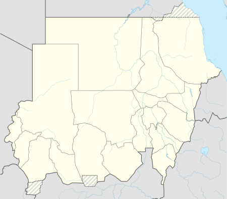 Atbara Location in Sudan | |
| Coordinates: 17°43′N 33°59′E / 17.717°N 33.983°E | |
| Country |
|
| Admin. division | River Nile State |
| Population (2007) | |
| • Total | 111,399 |
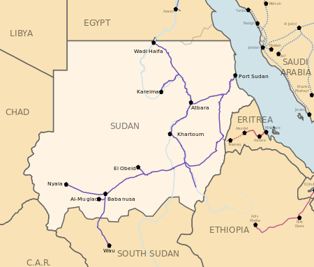


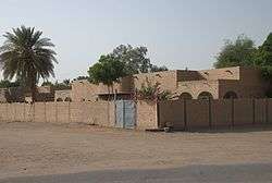
Atbara (sometimes Atbarah) (Arabic: عطبرة ʿAṭbarah) is a city of 111,399 (2007) located in River Nile State in northeastern Sudan. [1] It is located at the junction of the Nile and Atbara rivers. It is an important railway junction and railroad manufacturing centre, and most employment in Atbara is related to the rail lines. It is known as the "Railway City,' and The Sudanese National Railway Company's headquarters are located in Atbara.
History
The confluence of the Nile and its most northern tributary, the Atbara (Bahr-el-Aswad, or Black River) was a strategic location for military operations. In the Battle of Atbara, fought on 8 April 1898 near Nakheila, on the north bank of the river, Lord Kitchener's Anglo-Egyptian army defeated the Mahdist forces, commanded by Amir Mahmud Ahmad. Kitchener's strengthened position led to a decisive victory at the Battle of Omdurman on 2 September 1898,[2] giving the British control over the Sudan.[3]
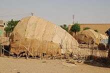
The town was the centre of the Sudanese railway industry. Few trains are made here now and rail traffic is much reduced. The original station and unusual dome-shaped houses of railway workers remain. The first trade union in Sudan formed in 1946 among railroad workers in Atbara. The city also is home to one of Sudan's largest cement factories, the Atbara Cement Corporation.
Perhaps because of the influence of the railway unions, Atbara is also considered by many to be the home of Sudanese communism. Jaafar Nimeiri, Sudan's president throughout the 1970s, alternated between communism, capitalism, and Islamic fundamentalism - depending on who he was trying to get on his side and extract money from - and the communist phase had its stronghold around Atbara.
Atbara is made up of several districts including Umbukole district which has the First Higher School in Atbara. Other districts include the railway district, Almurabaat, Alsawdana and Almatar.
Umbukole was originally the name given to a capital city in a northern state in Kurti county. It is now mostly remembered as the name of a small district in Atbara. A well-known resident is Mandour Elmahdi who wrote about the History of the Sudan.
Like Khartoum further upstream, Atbara is also at the confluence of two major rivers.
Climate
Atbara has a hot desert climate (Köppen climate classification BWh). The annual mean temperature reaches over 30 °C (86 °F) and the average highs exceed 40 °C (104 °F) during 7 months of the year. The annual average rainfall is 60 mm, mostly from July and August. Atbara is sunny, averaging 3,545 hours of bright sunshine per year or 81% of possible sunshine.
| Climate data for Atbara (1961–1990, extremes 1943–present) | |||||||||||||
|---|---|---|---|---|---|---|---|---|---|---|---|---|---|
| Month | Jan | Feb | Mar | Apr | May | Jun | Jul | Aug | Sep | Oct | Nov | Dec | Year |
| Record high °C (°F) | 41.0 (105.8) |
42.0 (107.6) |
45.7 (114.3) |
47.1 (116.8) |
47.5 (117.5) |
47.7 (117.9) |
47.0 (116.6) |
47.0 (116.6) |
46.0 (114.8) |
44.5 (112.1) |
40.7 (105.3) |
39.2 (102.6) |
47.7 (117.9) |
| Average high °C (°F) | 29.7 (85.5) |
31.9 (89.4) |
35.8 (96.4) |
39.4 (102.9) |
42.1 (107.8) |
42.8 (109) |
40.7 (105.3) |
40.1 (104.2) |
41.2 (106.2) |
39.3 (102.7) |
34.6 (94.3) |
30.8 (87.4) |
37.4 (99.3) |
| Daily mean °C (°F) | 22.1 (71.8) |
23.7 (74.7) |
27.5 (81.5) |
30.9 (87.6) |
34.1 (93.4) |
35.5 (95.9) |
34.0 (93.2) |
33.5 (92.3) |
34.3 (93.7) |
32.1 (89.8) |
27.4 (81.3) |
23.5 (74.3) |
29.9 (85.8) |
| Average low °C (°F) | 14.4 (57.9) |
15.4 (59.7) |
19.1 (66.4) |
22.3 (72.1) |
26.1 (79) |
28.2 (82.8) |
27.3 (81.1) |
26.9 (80.4) |
27.3 (81.1) |
25.0 (77) |
20.2 (68.4) |
16.1 (61) |
22.4 (72.3) |
| Record low °C (°F) | 6.0 (42.8) |
5.5 (41.9) |
10.0 (50) |
14.1 (57.4) |
18.8 (65.8) |
21.0 (69.8) |
19.0 (66.2) |
19.5 (67.1) |
20.0 (68) |
16.4 (61.5) |
13.0 (55.4) |
6.5 (43.7) |
5.5 (41.9) |
| Average precipitation mm (inches) | 0.0 (0) |
0.0 (0) |
0.0 (0) |
0.4 (0.016) |
3.5 (0.138) |
1.5 (0.059) |
19.1 (0.752) |
26.8 (1.055) |
6.7 (0.264) |
1.9 (0.075) |
0.0 (0) |
0.0 (0) |
59.9 (2.358) |
| Average precipitation days (≥ 0.1 mm) | 0.0 | 0.0 | 0.0 | 0.2 | 0.7 | 0.4 | 1.7 | 2.8 | 1.2 | 0.3 | 0.0 | 0.0 | 7.3 |
| Average relative humidity (%) | 36 | 28 | 22 | 20 | 20 | 22 | 32 | 36 | 30 | 29 | 35 | 38 | 29 |
| Mean monthly sunshine hours | 300.7 | 282.8 | 319.3 | 324.0 | 319.3 | 267.0 | 269.7 | 266.6 | 276.0 | 313.1 | 312.0 | 294.5 | 3,545 |
| Percent possible sunshine | 89 | 91 | 86 | 86 | 80 | 67 | 68 | 71 | 75 | 84 | 91 | 84 | 81 |
| Source #1: NOAA (averages, record highs for October and November, record lows for April, May, September through December)[4] | |||||||||||||
| Source #2: Meteo Climat (all other record highs and lows)[5] | |||||||||||||
Another chart with different averages is shown below.
| Climate data for Atbara (2000–2015) | |||||||||||||
|---|---|---|---|---|---|---|---|---|---|---|---|---|---|
| Month | Jan | Feb | Mar | Apr | May | Jun | Jul | Aug | Sep | Oct | Nov | Dec | Year |
| Average high °C (°F) | 31.2 (88.2) |
33.4 (92.1) |
36.6 (97.9) |
40.4 (104.7) |
43.0 (109.4) |
44.2 (111.6) |
42.8 (109) |
42.1 (107.8) |
42.3 (108.1) |
40.5 (104.9) |
36.0 (96.8) |
32.7 (90.9) |
38.77 (101.78) |
| Daily mean °C (°F) | 23.3 (73.9) |
24.7 (76.5) |
27.8 (82) |
31.1 (88) |
35.4 (95.7) |
36.2 (97.2) |
34.4 (93.9) |
34.7 (94.5) |
35.6 (96.1) |
33.1 (91.6) |
28.1 (82.6) |
24.6 (76.3) |
30.75 (87.36) |
| Average low °C (°F) | 15.2 (59.4) |
16.0 (60.8) |
18.9 (66) |
22.3 (72.1) |
27.4 (81.3) |
28.2 (82.8) |
27.3 (81.1) |
27.3 (81.1) |
29.1 (84.4) |
25.3 (77.5) |
20.1 (68.2) |
16.3 (61.3) |
22.78 (73) |
| Average precipitation mm (inches) | 0 (0) |
0 (0) |
0 (0) |
0 (0) |
3 (0.12) |
1 (0.04) |
18 (0.71) |
27 (1.06) |
7 (0.28) |
2 (0.08) |
0 (0) |
0 (0) |
58 (2.29) |
| Source #1: Global climatology for Atbara, Sudan[6] | |||||||||||||
| Source #2: Rainfall/Precipitation in Atbara, Sudan[7] | |||||||||||||
Demographics
| Year | Population |
|---|---|
| 1956 | 36.300 |
| 1973 | 66.116 |
| 1983 | 73.009 |
| 1993 | 87.878 |
| 2007 (Estimate) | 111.399 |
One of the major districts of Atbara is Al-Dakhla (الداخلة) in Arabic. Some still use the name Al-Dakhla referring to Atbara.
See also
References
- ↑ "'Atbarah, or Atbara (The Sudan)" (description), Encyclopædia Britannica, 2007, webpage: EB-Atbara.
- ↑ Chisholm 1911, p. 823.
- ↑ "The River War from Project Gutenberg". Onlinebooks.library.upenn.edu. Retrieved 2013-12-10.
- ↑ "Atbara Climate Normals 1961–1990". National Oceanic and Atmospheric Administration. Retrieved July 7, 2015.
- ↑ "Station Atbara" (in French). Meteo Climat. Retrieved 22 October 2016.
- ↑ "Global climatology for Atbara, Sudan<". Retrieved 31 May 2013.
- ↑ "Rainfall/Precipitation in Atbara, Sudan<". Retrieved 31 May 2013.
![]() This article incorporates text from a publication now in the public domain: Chisholm, Hugh, ed. (1911). "Atbara". Encyclopædia Britannica. 2 (11th ed.). Cambridge University Press. p. 823.
This article incorporates text from a publication now in the public domain: Chisholm, Hugh, ed. (1911). "Atbara". Encyclopædia Britannica. 2 (11th ed.). Cambridge University Press. p. 823.
External links
| Wikimedia Commons has media related to Atbarah. |
Coordinates: 17°41′50″N 33°58′42″E / 17.69722°N 33.97833°E