Athlunkard Street, Limerick
Athlunkard Street (Irish: Sráid Áth Longphuirt) is a street on King's Island, in Limerick City, Ireland. The street ends at the Abbey River, at the O'Dwyer Bridge. On its other end, after its intersection with Mary and Nicholas streets across the way from St. Mary's Cathedral, Athlunkard Street continues on to Matthew Bridge under the name Bridge Street.
Via the O'Dwyer Bridge and Athlunkard Avenue in Corbally, Athlunkard Street in Limerick leads toward the Athlunkard Bridge in Corbally, across the River Shannon from the townland of Athlunkard, County Clare, the Irish name of which, Áth Longphuirt, meaning "ford of the longphort," refers to a 9th-century Viking longphort (defended ship encampment) once located at that ford over the Shannon.[1]
Points of Interest
- Athlunkard Boat Club, established 1898.[2]
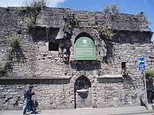
- Bourke’s House, constructed in 1690.
- O'Dwyer Bridge, constructed in 1931.[3]
- St Mary's Roman Catholic Church, which opened in 1932[4] as the parish church for St. Mary’s Parish, which was established at the Synod of Ráth Breasail in A.D.1111.[5]
References
- ↑ Kelly, Eamonn P.; O’Donovan, Edmond (Winter 1998). "A Viking longphort near Athlunkard, Co. Clare". Archaeology Ireland. 12 (4): 13–16.
- ↑ History of Athlunkard Boat Club
- ↑ Buildings of Ireland: O'Dwyer's Bridge
- ↑ St. Mary’s Church, RC
- ↑ St. Mary’s Parish