Atwater Village, Los Angeles
| Atwater Village | |
|---|---|
| Neighborhood of Los Angeles | |
|
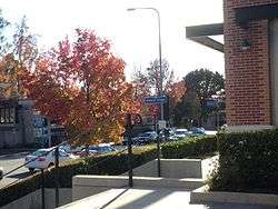
Atwater Village marker as seen on Los Feliz Blvd. | |
 Boundaries of Atwater Village as drawn by the Los Angeles Times | |
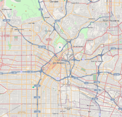 Atwater Village Location in Northeast Los Angeles | |
| Coordinates: 34°06′59″N 118°15′23″W / 34.11639°N 118.25639°WCoordinates: 34°06′59″N 118°15′23″W / 34.11639°N 118.25639°W |
Atwater Village is a highly diverse neighborhood in the 13th district of Los Angeles, California. Much of Atwater Village lies in the fertile Los Angeles River flood plain. Located in the northeast region of the city, Atwater borders Griffith Park and Silver Lake to the west, Glendale to the north and east, and Glassell Park to the south. It has three elementary schools—two public and one private. Almost half the residents were born abroad, a high percentage for the city of Los Angeles.
History
Much of Northeastern Los Angeles was part of Rancho San Rafael, until 1868, when parts of it were purchased by W.C.B. Richardson, who renamed it Rancho Santa Eulalia. The entire region was subdivided and sold to home builders in 1902, with the Atwater Village portion being named as such due to its proximity to the Los Angeles River. The area was initially named "Atwater," while the "Village" was added in 1986.[1]
Initial residents included the newly created middle-class workers employed at the nearby DWP substation. Its location between the Los Angeles and Glendale city cores made it a highly sought after residential neighborhood beginning in the 1920s. The vast majority of the homes and structures in Atwater Village have never been demolished (although many have changed in use or have been renovated), resulting in the neighborhood having one of the highest number of structures built before 1939 in Los Angeles County.[2]
Today, the neighborhood is among Los Angeles' most rapidly gentrifying, with an influx of young creative professionals (sometimes called "hipsters") and businesses catering to them, spilling over from the popular Silver Lake and Los Feliz areas.
Population
2013 findings
Census tracts 1883, 1881 and 1871.01 lie wholly within Atwater Village boundaries, and a large portion of census tract 1871.02 is also within Atwater Village.[3] Here are the five-year findings as reported by American Community Survey in 2013:
Census tract 1883 had a median income of $31,111 and was 37.8% non-Hispanic white, 34.1% Hispanic, 20.2% Asian, 1.6% Pacific Islander and 1.1% black.[4] Census tract 1871.01 had a median income of $72,526 and was 42.9% non-Hispanic white, 34.4% Hispanic, 21.2% Asian and 1.4% black.[5] Census tract 1881 was 60.3% Hispanic, 23.9% non-Hispanic white, 13.2% Asian, 2% black and 1.3% American Indian or Alaska Native. Median income for this census tract was $30,996.[4] Census tract 1871.02 was 47.9% Hispanic, 27.5% non-Hispanic white, 13.9% Asian and 8.4% black, with a median income of $24,852.[4]
2008 estimate
In 2008, the city estimated that 15,455 people lived in Atwater Village. [6]
2000 census
The 2000 U.S. census counted 14,888 residents in the 1.78-square-mile Atwater Village neighborhood—or 8,379 people per square mile, an average population density for the city.The median age for residents was 34, about average for the city.[6]
The neighborhood was considered highly diverse ethnically,[7] with a high percentage of Asians. The breakdown was Latinos, 51.3%; whites, 22.2%; Asians, 19.7%; blacks, 1.4%; and others, 5.4%. Mexico (27.2%) and the Philippines (20.4%) were the most common places of birth for the 49.3% of the residents who were born abroad—a high percentage, compared to the city at large.[6]
The median yearly household income in 2008 dollars was $53,872, an average figure for Los Angeles. The percentages of households that earned $20,000 to $60,000 yearly were high for Los Angeles County. The average household size of 2.7 people was average for Los Angeles. Renters occupied 59.6% of the housing stock, and house or apartment owners held 40.4%. The percentage of never-married women was among the county's highest.[6]
Geography
Much of Atwater lies in the old Los Angeles River flood plain, which resulted in deep, fertile soil.[8]
According to the Mapping L.A. project of the Los Angeles Times, Atwater Village is bordered on the north and east by Glendale, on the southeast by Glassell Park, on the south by Echo Park, on the southwest by Los Feliz and Silver Lake and on the west by Griffith Park.[9]
Street and other boundary limits are the Ventura Freeway on the north, San Fernando Boulevard on the east, and the Los Angeles River on the south and west.[6]
Nearby places
Relation of Atwater Village to nearby places, not necessarily contiguous:[9][10]
 |
Burbank | Glendale | Glendale | |
| Griffith Park | |
Forest Lawn | ||
| ||||
| | ||||
| Silver Lake | Echo Park | Glassell Park |
Education
Twenty-two percent of Atwater Park residents aged 25 and older had earned a four-year degree by 2000, an average figure for both the city and the county.[6]
Schools in Atwater Village are:[11]
- Glenfeliz Boulevard Elementary School, LAUSD, 3955 Glenfeliz Boulevard
- Holy Trinity Elementary School, private, 3716 Boyce Avenue
- Atwater Avenue Elementary School, LAUSD, 3271 Silver Lake Boulevard
Transportation
Atwater village is noted for its proximity to the Interstate 5, SR 134 and Interstate 110 freeways.
It is served by several Metro Bus lines, including the 92, 29, 180, 181, 201 and 780.[12]
It also is adjacent to Metrolink Glendale Station.
See also
References
- ↑ "Eastside Lifestyle," Atwater Village History, Eastside LA Lifestyle
- ↑ "Atwater Village" Atwater Village, City Data
- ↑ http://www2.census.gov/geo/maps/dc10map/tract/st06_ca/c06037_los_angeles/DC10CT_C06037_013.pdf
- 1 2 3 http://factfinder.census.gov/faces/tableservices/jsf/pages/productview.xhtml?pid=ACS_13_5YR_S0601&prodType=table
- ↑ http://factfinder.census.gov/faces/tableservices/jsf/pages/productview.xhtml?pid=ACS_13_5YR_S1903&prodType=table
- 1 2 3 4 5 6 "Atwater Village," Mapping L.A., Los Angeles Times
- ↑ Diversity "measures the probability that any two residents, chosen at random, would be of different ethnicities. If all residents are of the same ethnic group it's zero. If half are from one group and half from another it's .50." —Los Angeles Times
- ↑ "Future looks brighter in urban Atwater", LA Times, May 25, 2003
- 1 2 Colored map, Mapping L.A., Los Angeles Times
- ↑ The Thomas Guide: Los Angeles County, 2004, pages 631 and 632
- ↑ "Schools," Mapping L.A., Los Angeles Times
- ↑ "Metro" metro.net., LA Metro Home
External links
| Wikimedia Commons has media related to Atwater Village, Los Angeles. |
- Comments about living in Atwater Village
- Atwater Village crime map and statistics
- Atwater Village book
- Atwater Village Chamber of Commerce
- Friends of Atwater Village
- Atwater Village Neighborhood Council
- Councilman Eric Garcetti's website, 13th district
| Districts and neighborhoods |  | |
|---|---|---|
| Points of interest | ||
| Neighboring cities and communities | ||