Aunby
| Aunby | |
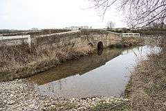 Ford and bridge over the River Glen near Aunby. This tributary of the West Glen is fed from the lakes at Holywell. |
|
 Aunby |
|
| OS grid reference | TF021146 |
|---|---|
| – London | 85 mi (137 km) S |
| Civil parish | Careby Aunby and Holywell |
| District | South Kesteven |
| Shire county | Lincolnshire |
| Region | East Midlands |
| Country | England |
| Sovereign state | United Kingdom |
| Post town | Stamford |
| Postcode district | PE9 |
| Police | Lincolnshire |
| Fire | Lincolnshire |
| Ambulance | East Midlands |
| EU Parliament | East Midlands |
| UK Parliament | Grantham and Stamford (UK Parliament constituency) |
|
|
Coordinates: 52°43′08″N 0°29′22″W / 52.7189°N 0.4894°W
Aunby is a village in the parish of Careby Aunby and Holywell (where the population is included), in the South Kesteven district of Lincolnshire, England. It is situated north from Stamford on the B1176 road,[1] and just south of Careby.
Aunby consists of Manor and Lodge farms, and a deserted medieval village.[2] The River Glen flows to the east of the village, next to the East Coast Main Line. Close to the west is Rutland.
References
- ↑ B1176, geograph.org.uk; retrieved 23 June 2011
- ↑ Historic England. "Aunby (348327)". PastScape. Retrieved 23 June 2011.
External links
![]() Media related to Aunby at Wikimedia Commons
Media related to Aunby at Wikimedia Commons
England Portal | |
| Unitary authorities | |
| Boroughs or districts | |
| Major settlements |
|
| Topics | |
This article is issued from Wikipedia - version of the 11/8/2016. The text is available under the Creative Commons Attribution/Share Alike but additional terms may apply for the media files.