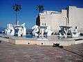
Bab El Oued
| Bab El Oued باب الوادى | |
|---|---|
| Commune | |
|
Bab El Oued | |
 Location of Bab El Oued in the Algiers Province | |
 Bab El Oued Location of Bab El Oued in the Algeria | |
| Coordinates: 36°47′26.53″N 3°2′59.03″E / 36.7907028°N 3.0497306°ECoordinates: 36°47′26.53″N 3°2′59.03″E / 36.7907028°N 3.0497306°E | |
| Country |
|
| Province | Algiers Province |
| District | Bab El Oued District |
| APC | 2012-2017 |
| Government | |
| • Type | Municipality |
| • Mayor | Athmane Sahbane |
| Area | |
| • Total | 43 sq mi (11,1 km2) |
| Population (2014) | |
| • Total | 214,900 |
| • Density | 149,000/sq mi (57,700/km2) |
| Time zone | CET (UTC+1) |
| Postal code | 16007 |
| ISO 3166 code | CP |
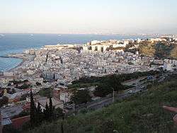
Bab El Oued is a neighbourhood in Algiers, the capital of Algeria, along the coast north of the city centre. As of 2008, the population of the commune of Bab El Oued was 64,732.[1]
History
During the existence of French Algeria, Bab El Oued became the main neighbourhood of poor pied-noirs, including many poor fishermen. Towards the end of the Algerian War of Independence, the neighbourhood became the stronghold of the Organisation de l'armée secrète, until OAS attacks on the French Army led them to assault and purge the neighbourhood, during the siege of Bab el Oued on March 1962. Soon after, Algeria became independent, and the pied noir population fled the country. The neighbourhood was rapidly reoccupied by Muslim Algerians.
The neighbourhood again gained notoriety during the leadup to the Algerian Civil War (which broke out in 1991) as a stronghold of the Islamic Salvation Front, or FIS. Its population in 1998 was 102,200.[2]
Notable residents

References
- ↑ "El Djazaïr (Province)". citypopulation.de. Retrieved 21 December 2014.
- ↑ populstat