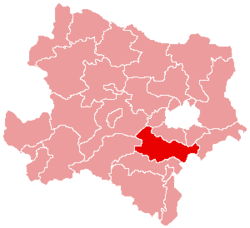
Baden District, Austria
| Bezirk Baden | |
|---|---|
| District | |
 | |
| Country | Austria |
| State | Lower Austria |
| Number of municipalities | 30 |
| Area | |
| • Total | 753.4 km2 (290.9 sq mi) |
| Population (2016-01-01[1]) | |
| • Total | 143,657 |
| • Density | 190/km2 (490/sq mi) |
| Time zone | CET (UTC+1) |
| • Summer (DST) | CEST (UTC+2) |
| NUTS code | AT122 |
Bezirk Baden is a district of the state of Lower Austria in Austria.
Municipalities
Towns (Städte) are indicated in boldface; market towns (Marktgemeinden) in italics; suburbs, hamlets and other subdivisions of a municipality are indicated in small characters.
- Alland
- Glashütten, Holzschlag, Rohrbach, Schwechatbach, Untermeierhof, Windhaag, Groisbach, Maria Raisenmarkt, Mayerling
- Altenmarkt an der Triesting
- Altenmarkt, Kleinmariazell, Nöstach, Sulzbach, Thenneberg
- Baden
- Bad Vöslau
- Bad Vöslau, Gainfarn, Großau
- Berndorf
- Berndorf-Stadt, St.Veit, Ödlitz, Veitsau/Steinhof
- Blumau-Neurißhof
- Blumau
- Ebreichsdorf
- Ebreichsdorf, Schranawand, Unterwaltersdorf, Weigelsdorf
- Enzesfeld-Lindabrunn
- Furth an der Triesting
- Aggsbach, Dürntal, Ebeltal, Eberbach, Furth, Guglhof, Hof, Maierhof, Niemtal, Rehgras, Steinwandgraben
- Günselsdorf
- Heiligenkreuz
- Füllenberg, Heiligenkreuz, Preinsfeld, Sattelbach, Siegenfeld
- Hernstein
- Aigen, Alkersdorf, Grillenberg, Hernstein, Kleinfeld, Neusiedl, Pöllau
- Hirtenberg
- Klausen-Leopoldsdorf
- Kottingbrunn
- Leobersdorf
- Mitterndorf an der Fischa
- Oberwaltersdorf
- Pfaffstätten
- Einöde, Pfaffstätten
- Pottendorf
- Landegg, Pottendorf, Siegersdorf, Wampersdorf
- Pottenstein
- Fahrafeld, Grabenweg, Pottenstein
- Reisenberg
- Schönau an der Triesting
- Dornau, Schönau an der Triesting, Siebenhaus
- Seibersdorf
- Deutsch-Brodersdorf, Seibersdorf
- Sooß
- Tattendorf
- Teesdorf
- Traiskirchen
- Möllersdorf, Oeynhausen, Traiskirchen, Tribuswinkel, Wienersdorf
- Trumau
- Weissenbach an der Triesting
- Gadenweith, Kienberg, Neuhaus, Schwarzensee, Weissenbach
References
- ↑ "Statistik Austria - Bevölkerung zu Jahresbeginn 2002-2016 nach Gemeinden (Gebietsstand 1.1.2016)", sdb.statistik.at, 2016-01-01.
Coordinates: 48°00′12″N 16°13′52″E / 48.00333°N 16.23111°E
This article is issued from Wikipedia - version of the 9/22/2014. The text is available under the Creative Commons Attribution/Share Alike but additional terms may apply for the media files.
