Baggrow
| Baggrow | |
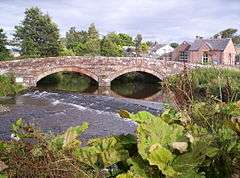 The bridge over the River Ellen, joining Baggrow with Blennerhasset. |
|
 Baggrow |
|
| OS grid reference | NY177419 |
|---|---|
| Civil parish | Allhallows |
| District | Allerdale |
| Shire county | Cumbria |
| Region | North West |
| Country | England |
| Sovereign state | United Kingdom |
| Post town | WIGTON |
| Postcode district | CA7 |
| Dialling code | 016973 |
| Police | Cumbria |
| Fire | Cumbria |
| Ambulance | North West |
| EU Parliament | North West England |
| UK Parliament | Workington |
Coordinates: 54°45′N 3°17′W / 54.75°N 03.29°W
Baggrow is a small village in the parish of Allhallows situated north of the Lake District in the English county of Cumbria. In many parts of the village views of England's 4th highest peak[1] Skiddaw, standing 931 metres (3053 ft) above sea level, can be seen to the South East, some 9½ miles away.
Railway
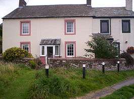
Station Manager's House as it is today
Baggrow railway station was a stop along the Bolton Loop of the Maryport and Carlisle Railway which used to run through the village serving the Brayton Knowle Colliery[2] here, and the mine at nearby Mealsgate. The line has been dismantled but evidence of its existence and its use can be seen along the route.[3]
References
External links
![]() Media related to Baggrow at Wikimedia Commons
Media related to Baggrow at Wikimedia Commons
This article is issued from Wikipedia - version of the 6/12/2016. The text is available under the Creative Commons Attribution/Share Alike but additional terms may apply for the media files.