Balfrin
| Balfrin | |
|---|---|
|
The north side | |
| Highest point | |
| Elevation | 3,796 m (12,454 ft) |
| Prominence | 235 m (771 ft) [1] |
| Parent peak | Dom |
| Coordinates | 46°08′06.3″N 7°52′49″E / 46.135083°N 7.88028°ECoordinates: 46°08′06.3″N 7°52′49″E / 46.135083°N 7.88028°E |
| Geography | |
 Balfrin Location in Switzerland | |
| Location | Valais, Switzerland |
| Parent range | Pennine Alps |
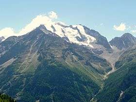
The Balfrin is a mountain of the Swiss Pennine Alps, located north of the Dom in the canton of Valais. It belongs to the Mischabel massif, which lies between the Mattertal and the Saastal.
The northern side of the Balfrin is covered by a glacier named Balfringletscher. On the south side is the larger Ried Glacier.
References
External links
| Wikimedia Commons has media related to Balfrin. |
This article is issued from Wikipedia - version of the 5/8/2016. The text is available under the Creative Commons Attribution/Share Alike but additional terms may apply for the media files.