Ballidon
| Ballidon | |
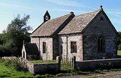
 Ballidon Church |
|
 Ballidon parish highlighted within Derbyshire |
|
| Population | 79 (2001 Census) |
|---|---|
| OS grid reference | SK203545 |
| District | Derbyshire Dales |
| Shire county | Derbyshire |
| Region | East Midlands |
| Country | England |
| Sovereign state | United Kingdom |
| Post town | ASHBOURNE |
| Postcode district | DE6 |
| Police | Derbyshire |
| Fire | Derbyshire |
| Ambulance | East Midlands |
| EU Parliament | East Midlands |
|
|
Ballidon is a village and civil parish in the Derbyshire Dales district of Derbyshire, England, on the edge of the Peak District National Park.[1][2] According to the 2001 census it had a population of 79. The population at the 2011 Census remained less than 100. Details are maintained in the civil Parish of Aldwark, Derbyshire. Ballidon was listed in the Domesday Book of 1086[3] and was a much larger village than seen today. That area now devastated by the Tilcon Quarry was a deep valley and the site of an ambush of troops of the Jacobean Rebellion, skulls and weaponry were recovered on the left bank (facing North).
References
- ↑ Ordnance Survey: Landranger map sheet 119 Buxton & Matlock (Chesterfield, Bakewell & Dove Dale) (Map). Ordnance Survey. 2012. ISBN 9780319231890.
- ↑ "Ordnance Survey: 1:50,000 Scale Gazetteer" (csv (download)). www.ordnancesurvey.co.uk. Ordnance Survey. 1 January 2016. Retrieved 30 January 2016.
- ↑ Professor J.J.N.Palmer. "Open Doomsday: Ballidon". www.opendomesday.org. Anna Powell-Smith. Retrieved 31 January 2016.
See also
External links
-
 Media related to Ballidon at Wikimedia Commons
 - Ballidon in the Domesday Book
Coordinates: 53°05′17″N 1°41′49″W / 53.088°N 1.697°W
This article is issued from Wikipedia - version of the 3/20/2016. The text is available under the Creative Commons Attribution/Share Alike but additional terms may apply for the media files.