DE postcode area
Postcode district boundaries: Bing / Google
Template:Attached KML/DE postcode area
KML is from Wikidata
The DE postcode area, also known as the Derby postcode area,[2] is a group of postcode districts around Alfreton, Ashbourne, Bakewell, Belper, Burton upon Trent, Derby, Heanor, Ilkeston, Matlock, Ripley and Swadlincote in England.
Coverage
The approximate coverage of the postcode districts:
| Postcode district |
Post town |
Coverage |
Local authority area |
| DE1 |
DERBY |
Derby city centre |
Derby |
| DE3 |
DERBY |
Derby (Mickleover) |
Derby, South Derbyshire |
| DE4 |
MATLOCK |
Sector 2:Darley Dale, Beeley, Rowsley, Winster, Darley Bridge, Elton, Bonsall
Sector 3:Matlock, Matlock Bath, Cromford
Sector 4: Middleton-by-Wirksworth, Wirksworth, Bolehill
Sector 5: Crich, Holloway, Lea, Tansley |
Derbyshire Dales, Amber Valley |
| DE5 |
RIPLEY |
Codnor, Denby, Ripley |
Amber Valley |
| DE6 |
ASHBOURNE |
Ashbourne, Hulland Ward, Weston Underwood |
Derbyshire Dales, Amber Valley, South Derbyshire, Derby, East Staffordshire |
| DE7 |
ILKESTON |
Horsley Woodhouse, Ilkeston, Morley, West Hallam |
Erewash, Amber Valley |
| DE11 |
SWADLINCOTE |
Church Gresley, Hartshorne, Newhall, Swadlincote |
South Derbyshire |
| DE12 |
SWADLINCOTE |
Appleby Magna, Donisthorpe, Linton, Measham, Overseal, Rosliston, Walton-on-Trent |
North West Leicestershire, South Derbyshire |
| DE13 |
BURTON-ON-TRENT |
Alrewas, Barton-under-Needwood, Rolleston on Dove, Tutbury |
East Staffordshire, Lichfield |
| DE14 |
BURTON-ON-TRENT |
Branston, Burton upon Trent, Newton Solney, Winshill |
East Staffordshire, South Derbyshire |
| DE15 |
BURTON-ON-TRENT |
Bretby, Stapenhill |
East Staffordshire, South Derbyshire |
| DE21 |
DERBY |
Derby (Chaddesden, Oakwood, Spondon); Breadsall, Horsley, Little Eaton |
Derby, Erewash, Amber Valley |
| DE22 |
DERBY |
Derby (Allestree, Darley Abbey, Mackworth (estate)); Kedleston, Mackworth (village), Quarndon |
Derby, Amber Valley |
| DE23 |
DERBY |
Derby (Heatherton Village, Littleover, Normanton, Pear Tree, Sunny Hill) |
Derby, South Derbyshire |
| DE24 |
DERBY |
Derby (Allenton, Alvaston, Boulton, Osmaston, Shelton Lock, Sinfin, Wilmorton); Stenson Fields |
Derby, South Derbyshire |
| DE45 |
BAKEWELL |
Ashford-in-the-Water, Bakewell, Baslow, Chatsworth, Edensor, Hassop, Monyash, Youlgreave |
Derbyshire Dales |
| DE55 |
ALFRETON |
Sector 1: Swanwick
Sectors 2 and 3: Alfreton, South Normanton
Sector 4: Riddings, Greenhill Lane, Leabrooks, Somercotes
Sector 5: Tibshelf, Newton, Blackwell, Hilcote
Sector 6: Wessington, Higham, Stonebroom, Morton, Shirland
Sector 7: Alfreton, South Wingfield |
Amber Valley, Bolsover |
| DE56 |
BELPER |
Ambergate, Belper, Duffield, Heage, Holbrook, Kilburn, Milford |
Amber Valley |
| DE65 |
DERBY |
Burnaston, Egginton, Etwall, Findern, Hatton, Hilton, Milton, Repton, Willington |
South Derbyshire |
| DE72 |
DERBY |
Ambaston, Aston-on-Trent, Borrowash, Breaston, Church Wilne, Draycott, Elvaston, Ockbrook, Risley, Shardlow, Weston-on-Trent |
Erewash, South Derbyshire, North West Leicestershire, |
| DE73 |
DERBY |
Derby (Chellaston); Barrow upon Trent, Ingleby, Melbourne, Stanton by Bridge, Swarkestone, Ticknall |
Derby, South Derbyshire |
| DE74 |
DERBY |
Castle Donington, Hemington, Kegworth |
North West Leicestershire |
| DE75 |
HEANOR |
Heanor, Loscoe |
Amber Valley |
| DE99 |
DERBY |
Non-geographic (Egg Banking) |
|
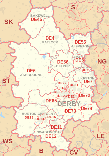
Map
Template:Attached KML/DE postcode area
KML is from Wikidata
DE postcode area map, showing postcode districts in red and post towns in grey text, with links to nearby
B,
CV,
LE,
NG,
S,
SK,
ST and
WS postcode areas.
See also
References
External links