Bankot
| Bankot bawan-kot | |
|---|---|
| village | |
|
Bankot Fort | |
| Nickname(s): BKT | |
 Bankot Location in Maharashtra, India | |
| Coordinates: 17°59′0″N 73°3′0″E / 17.98333°N 73.05000°ECoordinates: 17°59′0″N 73°3′0″E / 17.98333°N 73.05000°E | |
| Country |
|
| State | Maharashtra |
| District | Ratnagiri |
| Elevation | 46 m (151 ft) |
| Languages | |
| • Official | Marathi |
| Time zone | IST (UTC+5:30) |
| Telephone code | 02350 |
| Vehicle registration | MH-08 |
| Nearest city | mahad mandangad shrivardhan |
| Sex ratio | MlF ♂/♀ |
| Literacy | 100%% |
| Climate | cool (Köppen) |
Bankot is a town in India. It was made part of the Bombay Presidency in 1756.
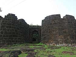
Its most famous structure is Bankot Fort (pictured). This was the first residency of the British Raj in Southern Konkan.
History
Although a consistent history about Bankot or Bankot fort is still eluding us and the origin of this fort is still speculative, a brief history can still be traced about this fort. The fort was known to be under the control of Adilshahi and later in 1548, the Portuguese took control over it. Later, Marathas, under the able leadership of the great Kanhoji Angre took control over Bankot. They rechristened the fort as Himmatgad. It is a historical place because it was the first residency in the Southern part of Konkan coast of British.In the year 1756 Bankot became the part of Bombay Presidency. Bankot fort is the main attraction here. Apart from this historic fort the nearby village of Velas village can be a treat to your eyes. The actual creator of this fort is not known to anyone but it is standing here since a long time and what is known is that it was under the ownership of Adilshahi till mid sixteenth century and after that in the year 1548 Portuguese captured this fort from Adilshahi dynasty as Portuguese were strengthening throughout the coast line. But Marathas then fought with Portuguese and took over the fort under the brave leader named Kanhoji Angre. The Marathas renamed the fort as Himmatgad. After Angre for some time the fort came under the control of British due to some internal divide and the fort was again named Fort Victoria by British. But when British saw no benefits to retain the ownership of this fort in terms of business or ruling they gave its ownership back to Peshwas. Due to its location this place could never witness any significant historical events during its life time except seeing various ownerships.If we see the structure of the fort it is in square shape. There a well in the premises that is said to be very deep. Like other forts in the region this fort also has a grand entrance gate decorated with multiple designs. As you enter the gate you proceed to a porch that is said to be the place where performance by musicians performed for the ruler of the fort. Now the remains of the fort can be explored as most of the structure is now damaged due to its age, lack of maintenance and usage.
Business
Mango (amba) is one of the most important crops of this village and mango trees occupy about 60 percent of land used to cultivate fruit. Hill-slopes near the coast where drainage is assured and climatic conditions are ideal, present most suitable site for mango cultivation. Cashew-nut (Kaju) stands next in importance to mango and occupies nearly one-third of the area used to cultivate fruit. Banana (kele) and coconut (nariyal) are grown on a smaller scale.
Sand dredging and mining have been major businesses since the 20th century.
Schools
1. German Parkar High School (Urdu)
2. Dr. A. R. Undre High School (English)
3. undre college of commerce (English) There are two kindergartens (Bal-wadi) for local kids (Urdu medium and Marathi medium). Literacy in Bankot is almost 99%. 4)Z.P.Primery Urdu school Bankot 5)Z.P.Bankot marathi shala 6)Z.P.Bankot killa marathi shala 7)Z.P.Bankot killa urdu school
Climate
Bankot is a nice place to visit in any season. The temperatures range from a minimum of 20°C and can go up to around the 34°C mark. Heavy rain & thunderstorms can be expected in monsoon season.
Nearest railway station
Karanjadi - 59 km. Veer - 67 km. Mangaon - 87 km. Khed- 70 km
Nearest airports
Lohagaon, Pune - 203 km. Chatrapati Shivaji International Airport, Mumbai - 180 km. Kolhapur - 240 km. Ratnagiri - 150 km
References
- ↑ Maharashtra State Gazetteers: Sholapur Gazetteer of India Volume 21 of Maharashtra State Gazetteers,. Directorate of Govt. Print., Stationery and Publications, Maharashtra State, 1960.