Bardufoss
| Bardufoss | |
|---|---|
|
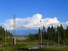
View of the Bardufoss area | |
 Bardufoss  Bardufoss Location in Troms | |
| Coordinates: 69°03′52″N 18°30′54″E / 69.06444°N 18.51500°ECoordinates: 69°03′52″N 18°30′54″E / 69.06444°N 18.51500°E | |
| Country | Norway |
| Region | Northern Norway |
| County | Troms |
| District | Midt-Troms |
| Municipality | Malselv |
| Elevation[1] | 68 m (223 ft) |
| Time zone | CET (UTC+01:00) |
| • Summer (DST) | CEST (UTC+02:00) |
| Post Code | 9325 Bardufoss |
.jpg)
Bardufoss is an urban area and commercial centre in the municipality of Målselv in Troms county, Norway. The three villages of Andselv, Andslimoen, and Heggelia together form the Bardufoss area. Bardufoss is located in the Målselvdalen valley near the confluence of the Barduelva and Målselva rivers. It is located about 82 kilometres (51 mi) north of the city of Narvik and about 70 kilometres (43 mi) south of the city of Tromsø. Bardufoss Airport is located here. The population (2001) was 2,580.[2]
Military
Bardufoss has a civilian and military airport, Bardufoss Air Station, suitable for landing bomber aircraft, fighter jets such as F-16s, and other heavy planes. Bardufoss was also the home of the Norwegian Army's 6th division (dissolved in 2009).
There is a street in Bardufoss that is named General Fleischers Veg in honour of Carl Gustav Fleischer.
The airport was renamed Snowman International on 19 March 2011 by a Norwegian Minister after a commercial flight landed from Manchester, England, to join the celebrations.
Nature
Bardufoss is covered in flora. The natural forest is mostly made up of Downy birch, Scots pine, aspen and Grey alder. However, Norway spruce has been planted in plantations since the middle part of the 20th century for economic reasons (timber).
Climate
Although not far from the coast, Bardufoss and Målselvdalen is known for a somewhat more continental climate, and hence, colder winters (but with less humidity and little wind) compared to the coastal areas. There is a very reliable snow cover in winter, while summer days often are warmer than in Tromsø.
There is on average 93 days each winter with daily low -10C or colder, and 28 days with low -20C or colder. The winter season sees on average 68 days with at least 50 cm snow cover on the ground, 126 days with at least 25 cm snow cover, and 179 days with at least 5 cm snow cover. In the warm season there is on average 116 days/ year when the daily average high reaches 10C or warmer and 22 days with daily average high above 20C. Precipitation is fairly moderate, there is on average 75 days/year with at least 3 mm precipitation and 15 days/year with at least 10 mm precipitation. This is based on data from Met.no with 1971-2000 as base period.[3]
| Climate data for Bardufoss (10 last years) | |||||||||||||
|---|---|---|---|---|---|---|---|---|---|---|---|---|---|
| Month | Jan | Feb | Mar | Apr | May | Jun | Jul | Aug | Sep | Oct | Nov | Dec | Year |
| Average high °C (°F) | −5 (23) |
−5 (23) |
−2 (28) |
4 (39) |
9 (48) |
14 (57) |
17 (63) |
15 (59) |
10 (50) |
4 (39) |
−2 (28) |
−5 (23) |
4.5 (40) |
| Average low °C (°F) | −11 (12) |
−11 (12) |
−9 (16) |
−2 (28) |
4 (39) |
8 (46) |
11 (52) |
9 (48) |
5 (41) |
−1 (30) |
−6 (21) |
−10 (14) |
−1.1 (29.9) |
| Average precipitation mm (inches) | 66 (2.6) |
58 (2.28) |
40 (1.57) |
33 (1.3) |
24 (0.94) |
38 (1.5) |
57 (2.24) |
63 (2.48) |
64 (2.52) |
77 (3.03) |
64 (2.52) |
68 (2.68) |
652 (25.67) |
| Average precipitation days (≥ 1 mm) | 10 | 10 | 10 | 7 | 8 | 8 | 10 | 10 | 11 | 11 | 9 | 10 | 124 |
| Source: Storm.no[4] | |||||||||||||
References
- ↑ "Bardufoss" (in Norwegian). yr.no. Retrieved 8 October 2012.
- ↑ Statistisk sentralbyrå (2001). "Folke- og boligtellingen 2001, kommune- og bydelshefter 1924 Målselv" (PDF) (in Norwegian).
- ↑ "Vanlig Vær Bardufoss" (in Norwegian). met.no. Retrieved 30 December 2013.
- ↑ "Bardufoss average conditions - base period 10 last years". Storm Weather Center. Archived from the original on 19 July 2011. Retrieved 3 December 2009.
External links
| Wikimedia Commons has media related to Bardufoss. |