Barentsburg
| Barentsburg | |
|---|---|
| Russian coal mining settlement | |
|
The town from above | |
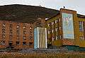
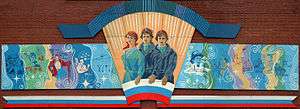 Heroic Soviet-style mural on the community centre building, Barentsburg | |
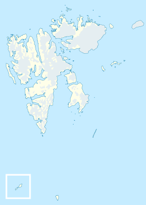 Barentsburg Location in western Svalbard | |
| Coordinates: 78°04′0″N 14°13′0″E / 78.06667°N 14.21667°E | |
| Country | Norway |
| Syssel | Svalbard |
| island | Spitsbergen |
| Population (2015) | |
| • Total | 471[1] |
| Time zone | CET (UTC+1) |
| • Summer (DST) | CEST (UTC+2) |

Barentsburg (Russian: Баренцбург) is the second-largest settlement on Svalbard, with about 500 inhabitants (2007), almost entirely Russians and Ukrainians. It is the site of the Barentsburg Pomor Museum.
History
Named after Dutch explorer Willem Barents, the town is a mining town, with coal mining conducted by the Soviet company Arktikugol since 1932. The population has declined over the decades; in its heyday, over 1,000 Soviet citizens inhabited Barentsburg.
Status
Although Svalbard is under Norwegian sovereignty, the unique Svalbard Treaty of 1920 allows citizens of signatory countries equal rights to exploit natural resources. Russia, along with Norway (via the Sveagruva mine and Mine 7), maintains mining operations on Svalbard as a result. Russia maintains a consulate in Barentsburg,[2] the northernmost diplomatic mission of any kind in the world. Barentsburg still has a Norwegian mail address and Norwegian phone numbers.
Economic basis
Barentsburg started as a Dutch mining town in the 1920s.[3] In 1932 the Dutch sold their concession to the Soviet Union.[4] Since 1932 the Russian state-owned Arktikugol Trust (Russian for "Arctic Coal") has been operating on Svalbard. The main economic activity is coal mining by the Arktikugol (Арктикуголь) company. The coal is usually exported to Northern European buyers. The town relies entirely on mainland Russia for food and coinage. There have been instances in which not enough food was sent, and aid packages were sent from Longyearbyen. Tourism is now being developed, but does not yet generate enough income to revive the town.
Transportation
The distance from Longyearbyen to Barentsburg is about 55 km but there are no roads connecting the two settlements. Most contact between the two is by boat, snowmobile, or helicopter. There is a heliport (ICAO code ENBA) with a road connection at Heerodden (78°06′03″N 14°11′46″E / 78.100809°N 14.196224°E), 4 km north of Barentsburg. Tourists usually arrive via a 2-3-hour boat trip from Longyearbyen. The coal is freighted by ship. The port is located in the middle of Barentsburg.
Climate
| Climate data for Barentsburg | |||||||||||||
|---|---|---|---|---|---|---|---|---|---|---|---|---|---|
| Month | Jan | Feb | Mar | Apr | May | Jun | Jul | Aug | Sep | Oct | Nov | Dec | Year |
| Record high °C (°F) | 6.8 (44.2) |
5.6 (42.1) |
4.1 (39.4) |
5.3 (41.5) |
9.9 (49.8) |
14.6 (58.3) |
20.3 (68.5) |
17.5 (63.5) |
12.1 (53.8) |
8.5 (47.3) |
6.8 (44.2) |
5.9 (42.6) |
20.3 (68.5) |
| Average high °C (°F) | −9.1 (15.6) |
−9.4 (15.1) |
−9.4 (15.1) |
−6.4 (20.5) |
−1.1 (30) |
4.0 (39.2) |
8.4 (47.1) |
7.2 (45) |
2.9 (37.2) |
−2.6 (27.3) |
−5.1 (22.8) |
−7.4 (18.7) |
−2.3 (27.9) |
| Daily mean °C (°F) | −12.1 (10.2) |
−12.7 (9.1) |
−12.4 (9.7) |
−9.7 (14.5) |
−3.3 (26.1) |
2.2 (36) |
6.0 (42.8) |
5.1 (41.2) |
1.0 (33.8) |
−4.7 (23.5) |
−7.6 (18.3) |
−10.5 (13.1) |
−4.9 (23.2) |
| Average low °C (°F) | −15.2 (4.6) |
−15.7 (3.7) |
−15.5 (4.1) |
−12.1 (10.2) |
−5.1 (22.8) |
0.8 (33.4) |
4.4 (39.9) |
3.6 (38.5) |
−0.4 (31.3) |
−6.6 (20.1) |
−10.1 (13.8) |
−12.9 (8.8) |
−7.1 (19.2) |
| Record low °C (°F) | −37.1 (−34.8) |
−39.3 (−38.7) |
−39.8 (−39.6) |
−31.3 (−24.3) |
−22.5 (−8.5) |
−9.2 (15.4) |
−0.7 (30.7) |
−3.5 (25.7) |
−12 (10) |
−27.1 (−16.8) |
−29.3 (−20.7) |
−37.3 (−35.1) |
−39.8 (−39.6) |
| Average precipitation mm (inches) | 61 (2.4) |
50 (1.97) |
56 (2.2) |
44 (1.73) |
28 (1.1) |
21 (0.83) |
25 (0.98) |
35 (1.38) |
54 (2.13) |
56 (2.2) |
59 (2.32) |
63 (2.48) |
552 (21.73) |
| Average rainy days | 2 | 1 | 2 | 1 | 3 | 10 | 17 | 16 | 12 | 4 | 3 | 2 | 73 |
| Average snowy days | 24 | 20 | 22 | 20 | 20 | 10 | 1 | 3 | 14 | 22 | 23 | 24 | 203 |
| Average relative humidity (%) | 77 | 77 | 77 | 77 | 79 | 81 | 81 | 82 | 81 | 77 | 77 | 77 | 79 |
| Source: Pogoda.ru.net[5] | |||||||||||||
Science and culture

The Barentsburg Pomor Museum presents Pomor culture, Arctic flora and fauna, and archeological objects preserved in the permafrost. It is open when the daily, summer-only boat from Longyear arrives and by special arrangement. There is an athletic complex, including a swimming pool with heated seawater. Every summer, several dozen geophysicists, geologists, archeologists, biologists, glaciologists, geographers, etc., from Russia and elsewhere work in the scientific research centre. There is also a year-round meteorological observatory and the northernmost cosmic rays station.
Dream Town
Adrian Briscoe completed Dream Town, a feature-length film about Barentsburg, in 2014. Part documentary, part fantasy, Dream Town examines the stark reality of the miners, scientists, and children who live there and contrasts their unusual existence with fictional interludes they created with the director. From documentary to fiction, the film concludes with a series of resolutions centered on the themes of love, dreams and escapism.
Co-written by novelist Ray Robinson, Dream Town won the Best Picture award at both the Chicago Underground Film Festival and the Derby Film Festival, UK in the spring of 2014.
2006 fire
On October 17, 2006 Norwegian inspectors detected a smoldering underground fire in Barentsburg, prompting fears that an open fire might break out,[6] which would have forced the total evacuation of Barentsburg for an indefinite period of time, and also cause unknown environmental problems for the entire archipelago. The fire was later contained.[7] Coal mining resumed at the end of 2010.[8]
Gallery
-
.jpg)
Barentsburg from the air
-

Barentsburg from the seaside
-

Barentsburg: mining and polar bears at 78° north
-
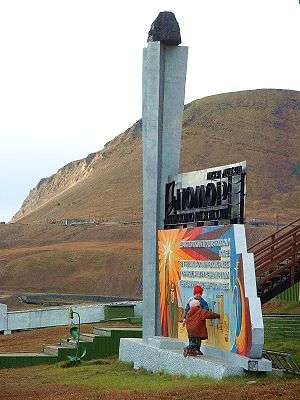
Monument to coal
-
Barentsburg, as seen from the docks
-
The world's second northernmost statue of Lenin (the northernmost is in Pyramiden)
-

The main street, ulitsa Ivana Starostina. The abandoned buildings on the right are being demolished as of 2013.

| Wikimedia Commons has media related to Barentsburg. |
References
- ↑ http://www.ssb.no/en/befolkning/statistikker/befsvalbard/halvaar/2015-04-09?fane=tabell&sort=nummer&tabell=223337
- ↑ Russian Embassy in Norway website
- ↑ Umbreit, Andreas (2009). Spitsbergen (4 ed.). Bradt Travel Guide. p. 35. ISBN 978-1-84162-240-8.
- ↑ Barr, Susan (2003). Norway, a consistent polar nation?: analysis of an image seen through the history of the Norwegian Polar Institute. Kolofon. p. 174. ISBN 978-82-300-0026-7.
- ↑ "Weather and Climate- The Climate of Barentsburg" (in Russian). Weather and Climate (Погода и климат). Retrieved 14 May 2015.
- ↑ Norway Svalbard Coal Fire. International Herald Tribune. November 1, 2006.
- ↑ Barentsburg: Kullbrann kan føre til evakuering Archived June 29, 2011, at the Wayback Machine. Aftenposten 1 November 2006
- ↑ Staalesen, Atle (2010-11-08). "Russians restarted coal mining at Svalbard". Barents Observer. Retrieved 2010-01-26.
External links
 Barentsburg travel guide from Wikivoyage
- Dream Town, Film Trailer
- Barentsburg Research Base Official site
- Barentsburg Cosmic Ray Station from the Polar Geophysical Institute
- Map and guide, with photos in English Japanese version of site
- Barentsburg photos from Galen R Frysinger site
- Many photos of Barentsburg on this flickr site
- More photos of Barentsburg from a Svalbard site
- Story on Barentsburg from the BBC, December 25, 2006
Coordinates: 78°04′N 14°13′E / 78.067°N 14.217°E