Batamay, Kobyaysky District, Sakha Republic
| Batamay (English) Батамай (Russian) | |
|---|---|
|
- Rural locality[1] - Selo[1] | |
 | |
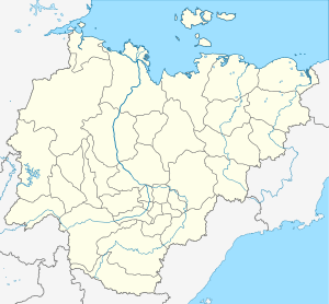
_Republic_(2008-03).svg.png) Location of the Sakha (Yakutia) Republic in Russia | |
 Batamay | |
|
| |
| Administrative status (as of June 2009) | |
| Country | Russia |
| Federal subject | Sakha Republic[1] |
| Administrative district | Kobyaysky District[1] |
| Rural okrug | Kirovsky Rural Okrug[1] |
| Municipal status (as of April 2012) | |
| Municipal district | Kobyaysky Municipal District[2] |
| Rural settlement | Kirovsky Rural Settlement[2] |
| Statistics | |
| Population (2002 est.) | 216 inhabitants[1] |
| Time zone | YAKT (UTC+09:00)[3] |
| Postal code(s)[4] | 678312 |
| Batamay on Wikimedia Commons | |
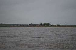
Batamay (Russian: Батамай) is a rural locality (a selo), and one of two settlements in Kirovsky Rural Okrug of Kobyaysky District in the Sakha Republic, Russia, in addition to Segyan-Kyuyol, the administrative center of the Rural Okrug. It is located 160 kilometers (99 mi) from Sangar, the administrative center of the district and 90 kilometers (56 mi) from Segyan-Kyuyol. Its population as of the 2002 Census was 216.[1]
Climate
| Climate data for Batamay, Kobyaysky District | |||||||||||||
|---|---|---|---|---|---|---|---|---|---|---|---|---|---|
| Month | Jan | Feb | Mar | Apr | May | Jun | Jul | Aug | Sep | Oct | Nov | Dec | Year |
| Record high °C (°F) | −8.9 (16) |
−6.6 (20.1) |
8.0 (46.4) |
20.0 (68) |
28.0 (82.4) |
32.6 (90.7) |
38.0 (100.4) |
37.0 (98.6) |
24.8 (76.6) |
13.9 (57) |
−1.3 (29.7) |
−11.9 (10.6) |
38.0 (100.4) |
| Average high °C (°F) | −36.9 (−34.4) |
−31.1 (−24) |
−15.9 (3.4) |
−1.8 (28.8) |
10.1 (50.2) |
19.6 (67.3) |
23.0 (73.4) |
19.5 (67.1) |
9.9 (49.8) |
−6.7 (19.9) |
−26.0 (−14.8) |
−35.8 (−32.4) |
−5.5 (22.1) |
| Daily mean °C (°F) | −40.4 (−40.7) |
−36.2 (−33.2) |
−22.8 (−9) |
−8.1 (17.4) |
5.1 (41.2) |
14.1 (57.4) |
17.3 (63.1) |
13.7 (56.7) |
4.9 (40.8) |
−10.5 (13.1) |
−29.9 (−21.8) |
−39.2 (−38.6) |
−10.5 (13.1) |
| Average low °C (°F) | −45.3 (−49.5) |
−42.9 (−45.2) |
−32.2 (−26) |
−16.9 (1.6) |
−1.5 (29.3) |
6.8 (44.2) |
9.8 (49.6) |
6.4 (43.5) |
−1.1 (30) |
−15.9 (3.4) |
−35.3 (−31.5) |
−43.8 (−46.8) |
−17.2 (1) |
| Record low °C (°F) | −65.7 (−86.3) |
−58.9 (−74) |
−53.2 (−63.8) |
−42.3 (−44.1) |
−22.2 (−8) |
−6.4 (20.5) |
−4.0 (24.8) |
−7.2 (19) |
−19.1 (−2.4) |
−45.0 (−49) |
−52.7 (−62.9) |
−60.0 (−76) |
−65.7 (−86.3) |
| Average precipitation mm (inches) | 8.4 (0.331) |
9.4 (0.37) |
9.9 (0.39) |
12.3 (0.484) |
24.8 (0.976) |
74.3 (2.925) |
46.6 (1.835) |
71.4 (2.811) |
44.9 (1.768) |
44.3 (1.744) |
22.7 (0.894) |
11.4 (0.449) |
380.4 (14.976) |
| Average precipitation days | 14.4 | 10.7 | 8.4 | 6.3 | 9.1 | 7.9 | 8.3 | 8.9 | 10.8 | 19.6 | 18.5 | 12.6 | 135.5 |
| Source: [5] | |||||||||||||
References
Notes
- 1 2 3 4 5 6 7 Registry of the Administrative-Territorial Divisions of the Sakha Republic
- 1 2 Law #173-Z 353-III
- ↑ Правительство Российской Федерации. Федеральный закон №107-ФЗ от 3 июня 2011 г. «Об исчислении времени», в ред. Федерального закона №271-ФЗ от 03 июля 2016 г. «О внесении изменений в Федеральный закон "Об исчислении времени"». Вступил в силу по истечении шестидесяти дней после дня официального опубликования (6 августа 2011 г.). Опубликован: "Российская газета", №120, 6 июня 2011 г. (Government of the Russian Federation. Federal Law #107-FZ of June 31, 2011 On Calculating Time, as amended by the Federal Law #271-FZ of July 03, 2016 On Amending Federal Law "On Calculating Time". Effective as of after sixty days following the day of the official publication.).
- ↑ Почта России. Информационно-вычислительный центр ОАСУ РПО. (Russian Post). Поиск объектов почтовой связи (Postal Objects Search) (Russian)
- ↑ "Weather Averages for Batamay, Kobyaysky District (1948-2011)". climatebase.ru. Retrieved 17 December 2014.
Sources
- Official website of the Sakha Republic. Registry of the Administrative-Territorial Divisions of the Sakha Republic. Kobyaysky District. (Russian)
- Государственное Собрание (Ил Тумэн) Республики Саха (Якутия). Закон №173-З №353-III от 30 ноября 2004 г. «Об установлении границ и о наделении статусом городского и сельского поселений муниципальных образований Республики Саха (Якутия)», в ред. Закона №1058-З №1007-IV от 25 апреля 2012 г. «О внесении изменений в Закон Республики Саха (Якутия) "Об установлении границ и о наделении статусом городского и сельского поселений муниципальных образований Республики Саха (Якутия)"». Вступил в силу со дня официального опубликования. Опубликован: "Якутия", №245, 31 декабря 2004 г. (State Assembly (Il Tumen) of the Sakha (Yakutia) Republic. Law #173-Z No. 353-III of November 30, 2004 On Establishing the Borders and on Granting the Urban and Rural Settlement Status to the Municipal Formations of the Sakha (Yakutia) Republic, as amended by the Law #1058-Z No. 1007-IV of April 25, 2012 On Amending the Law of the Sakha (Yakutia) Republic "On Establishing the Borders and on Granting the Urban and Rural Settlement Status to the Municipal Formations of the Sakha (Yakutia) Republic". Effective as of the day of the official publication.).
This article is issued from Wikipedia - version of the 10/28/2016. The text is available under the Creative Commons Attribution/Share Alike but additional terms may apply for the media files.