Batavia Castle

Batavia Castle (Dutch Kasteel Batavia) was a fort located at the mouth of Ciliwung River in Jakarta. Batavia Castle was the administrative center of Dutch East India Company in Asia.[1] Batavia Castle was also the residence of the Governor-General, the highest VOC official in the East Indies who chaired the Council of the Indies, the executive committee that took the decisions in the East Indies.[1]
History
Pieter Both, the first elected Governor-General of the Dutch East Indies, appointed Captain Jacques l'Hermite to acquire a 2,500 square vadem (10,000 square yards)[2] of land in Jayakarta in order to establish a VOC loge (trading post).[3] The request was granted by Prince Jayawikarta, the ruler of Jayakarta, under a large sum of money (1200 real).[4] This land is located on the eastern bank of Ciliwung near the Chinese quarter.[5] In 1612, the Dutch built a loge, a huis, and a factorij on this land; altogether known as Nassau Huis.[3][2] This agreement was maintained during the governance of Governor-General Gerard Reynst and later Laurens Reael.[3]
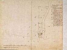
When Jan Pieterszoon Coen became the Governor-General of Dutch East Indies, he built another loge to the east of Nassau Huis in 1617, named Mauritius.[2] In 1618, Coen built a slipway, a hospital, and masonry cannon ex-placements that supplemented the cannons to these loge on the island of Onrust. Later, Coen fortified the two houses into a square fort surrounded with solid stone wall of 9 feet tall and 6 to 7 feet thick, as well as equipping it with cannons.[6] This new fort building was known as Fort Jacatra. When Coen sailed to Ambon, Pieter de Carpentier took over the position of Governor-General temporarily and was responsible in managing Fort Jacatra. This new situation created a tension between VOC and Prince Jayawikarta.[3]
When the Sultanate of Banten decided to remove Prince Jayawikarta from his position because he was accused of having a friendship agreement with British without prior approval; the VOC celebrated the decision and planned a new Castle on 12 March 1619 named Batavia Castle. Coen was quiet angry to know that his request to name the Castle and the city Nieuw Hoorn (after his birthplace) was not granted.[7] Batavia Castle was nine times larger than Fort Jacatra and engulfed the eastern part of Fort Jacatra.[4] On 30 May 1619, Coen destroyed Jayakarta and expelled its population, the area becoming part of Batavia.[8] On 4 March 1621, Batavia was officially the name of the city as well as the center of VOC trade empire which extend from the Cape of Good Hope to Japan.[3]
Construction of Batavia Castle started in 1620; the spot is just to the east of Fort Jacatra.[9] Construction took a long period due to the lack of proper building materials.[9] Buildings materials were asked again and again by the Governor General and Council on the so-called "lists of demands" (the Eijs) which were sent to the Netherlands.[9] Little by little Fort Jacatra was engulfed by the Batavia Castle until its complete demolition between 1627 and 1632.
At the end of the term of office of Antonio van Diemen, the fort had its form and arrangements that it kept until the end. Inside the walls however, things were changing constantly.[10] Also changing were the coastline of Batavia. Since Batavia Castle was situated on a low-lying coastal plain with swamps on either side, its canals hardly flowed and sediments from the mud-filled connecting river sank to the bottom. Rapid silting up also occurred on the beach. At the end of the 18th-century Batavia Castle, initially built on the seashore, lay more than two kilometers inland. The silted-up coast played an important role in the unhealthiness of Batavia: at high tide this area was washed by the sea and covered with the refuse of the town and poisonous jellyfish. At low tide, sea water stayed behind in many puddles and basins. Batavians believed that illness was spread by "evil vapors" rising from the soil, containing miasmata - small airborne particles carrying diseases. Other features which contribute to the decline of Batavia in general were the polluted canals, the church-yards, the quality of the drinking water, and the digging of waterways.[11]
In 1751, the southern (land-side) curtain wall, together with its Landpoort, were demolished; opening the castle to the Kasteelplein.[10] In 1756, the sea-side Waterpoort was rebuild.[10] Around this period, Batavia had become so diseased that people moved to the cleaner south region of the city. Complete dismantle of the Castle started in 1809 when governor Daendels decided to moved the administrative center to southern area Weltevreden. Batavia Castle was slowly demolished and its stones were reused to build the new Palace of Daendels (now the Indonesian Ministry of Finance).[1] Factories and warehouses were built in the area where the castle once stood, and has stayed this way until now.[10]
Structure
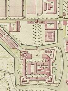
At its largest extent, Batavia Castle was a square-shaped structure equipped with four protruding bastions named after precious stones: Parel (Pearl) at northwest, facing the Kali Besar; Diamant (Diamond) at the southwest; Saphier (Saphhire) at northeast, facing the buffelsveld ("buffalo field"); and Robijn (Ruby) at southeast facing the Tijgersgracht. The unique names of the bastions earned the city the Malay name Kota Intan, "Diamond City". These bastions were made of solid earthen walls and coral with strong wooden palisade. Two main portals gave access to the inside of the Castle: the south (land) side Landpoort and the north (sea) side Waterpoort. The north-south axis is about 290 treden (steps) and the east-west is 274 treden.[1] Late 17th-century visitors described the Castle as large and strong.[12]
Inside the Castle were several administration buildings and a series of courtyards.[13] In late 17th-century, the Castle is guarded by fifteen cannons and five-to-six companies of soldiers.[13]
The administration buildings

The castle housed the administration buildings of the VOC, including the Governor-General's residence, the General-Director's residence, residences for high officials (e.g. chief merchants, the Company's chief surgeon, the chief of the armory, the chief customs officer, as well as many bookkeepers, assistants, and the and craftsmen),[13] several workshops, a treasury, a garrison, an armory, a prison, some storehouses (for VOC merchandise, food, medical supplies, and military equipment), a chapel and the meeting hall of the council of the Indies.[1] There were around 150 people stayed in the Castle during the end of 17th-century.[13] The castle contains no settlements as the VOC had already prepared a fortified settlement to the south of the castle. This settlement were separated with the castle by a canal called Kasteelgracht.
The Governor-General's residence is the largest and the tallest structure in the Castle. It is a three-storeyed structure complete with a central cupola which provides a commanding view of the town and harbor.[13] The Governor-General's residence is situated on the largest courtyard in the Castle. The residence also houses the VOC's auditor's office, the secretariat, and the chambers in which the Council of the Indies meets. The residence contains an inner courtyard with many facilities positioned facing it, such as the kitchen, and other rooms. A pavilion provides a space for entertainment.
Under the Diamond Point inside the Castle stands a small octagonal stone chapel in which Dutch Reformed services are preached twice each Sunday.[14]
Another gate placed in straight line with the landpoort is the pinangpoort ("pinang gate").
The gateways
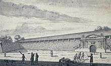
The main gates of Castle Batavia is the sea-side (northern) gateway and the land-side (southern) gateway. The seaside gateway, the waterpoort ("water gate"), is decorated with Neoclassical ornaments both on the inside and on the outside, both with inscription anno 1630. This ornaments were imported from the Netherlands. The land-side southern gateway is known as the landpoort ("land gate"); this entrance was built earlier than the waterpoort but received the neoclassical decoration several years later.
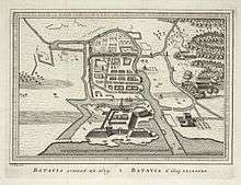
A 1623 map shows that at that time the north sea-side walls of the Castle were unfinished while the south land-side walls were already finished, as if it was prepared for a land-side attack. At the end of 1627 the Governor General and Council agreed to build a permanent two story building with a flat roof between the seaside bastions Parel and Saphier. This remained a plan because when the Castle was attacked by the Javanese in August 1628 the Governor-General and the Council realized that the Castle's fortifications were not strong enough. A resolution was taken to consolidate the Castle without delay on September 9, 1627. In February 1629, the two sea-bastions were finally made and closed, two walls were finished: the first curtain on the West-side 16 voet (feet) high and the second at the south (land)-side. Coen expressed hope that he would finish the eastern and northern walls soon.[15]
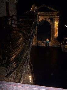
Pieter van den Broecke, who visited Batavia from June until the end of December 1629 published a bird eye's view of Batavia in late 1629. The picture showed the completed sea-side wall of Batavia Castle but the entrance has only some wood scaffolding with no neoclassic gate decoration. It is not clear what happened between 1629 and the 1630s because of the lack of documents, however in later etching of the Castle in mid 1630s, the Waterpoort had already complete with the gate decoration.[16] The shape of this decoration is similar to that found on the ship the Batavia, and which gate is now in the Maritime Museum in Fremantle. Up to now, it has been assumed that the gate decoration in the Maritime Museum was the one destined for the Watergate of the Castle of Batavia. Evidence for this assumption is a gold pendant, dated 25 November 1632, which was made to commemorate the Chinese contribution to the defeat of the army of Mataram. It clearly shows the completed Watergate.[16]
The decorative portals of Batavia Castles were usually constructed in the Netherlands and later shipped to Batavia. The Batavia fleet was supposed to carry the decorative gates for the gates of Castle Batavia. Batavia, which departed from Texel on October 29, 1628, was shipwrecked on the Houtman Abrolhos, Western Australia, on June 4, 1629. On July 7, 1692, Pelsaert arrived at Batavia to report the shipwreck, so on July 15 the Sardam departed from Batavia to rescue the Batavia fleet and salvage the goods which include material for the decorative gates. Sardam arrived at the wreck-site on September 17, 1629 and stayed there until November 15. It arrived back at Batavia on December 5, 1629.[16]
It is very likely that four decorative facades were sent for Batavia Castle in the fleet of Batavia of 1628. Only three arrived and were fitted: two for the Waterpoort (on the inside and outside) and one for the Landpoort. A new facade was ordered and placed for the Landpoort only in 1637. One other decorative portico in the Castle was inscribed 1637 as well, namely the gate of the Palais of the Opperlandvoogd, which was the Governor-General. Possibly a new load with decorative facades was sent with the 1636 fleet, and fitted in 1637.[16]
The castle's perimeter
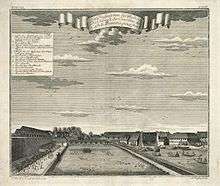
There were two other gateways in the perimeter of Castle Batavia: the vijverpoort ("pool gate") near Bastion Parel, and Delftschepoort ("Delft gate") near Bastion Robijn. The vijverpoort divided the area in front of the waterpoort with an enclosed garden to the west of Batavia Castle between Bastion Parel and Bastion Diamant. This enclosed garden contains a large duck pond, the longest dimension is the same as the Castle itself. A playhouse (speelhuisje) was built over the duck pond.[1]
The field to the east of the Castle is known as the Königs Platz or Koningsplaats where water buffaloes grazed.
Batavia Castle was surrounded by a gracht known as the Kasteelgracht that also functioned as a defensive moat.[1] A stone bridge (steenebrug) of fourteen arches spans the Kasteelgracht, connecting the Castle with a large field containing a gibbet, whipping post and wheel. A small bridge on the other side of the field leads to a guarded gate and the city's main street.[17]
Today
Today the street Jalan Tongkol (formerly Kasteelweg and Kasteelstraat) passed through the center of an area where Batavia Castle used to stand. The area is designated part of the Jakarta Old Town historic area.
See also
| Wikimedia Commons has media related to Batavia Castle. |
References
- 1 2 3 4 5 6 7 Ensiklopedi Jakarta - Kasteel van Batavia 2010.
- 1 2 3 American Universities Field Staff 1966, p. 237.
- 1 2 3 4 5 Ito 2007, pp. 196-8.
- 1 2 Ensiklopedi Jakarta - Jacatra Fort 2010.
- ↑ Kratoska 2001, p. 120.
- ↑ Ensiklopedi Jakarta 2010.
- ↑ van Wamelen 2014, p. 65.
- ↑ Restu Gunawan 2010, p. 35.
- 1 2 3 Huystee 1994, p. 4.
- 1 2 3 4 Huystee 1994, p. 7.
- ↑ Grijns & Nas 2000, p. 47.
- ↑ Lach & Kley 2000, p. 1314.
- 1 2 3 4 5 Lach & Kley 2000, p. 1315.
- ↑ Lach & Kley 2000, pp. 1314-5.
- ↑ Huystee 1994, p. 5.
- 1 2 3 4 Huystee 1994, p. 6.
- ↑ Lach & Kley 2000, p. 1316.
Works cited
- American Universities Field Staff (1966). Report Service: Southeast Asia series (Report). Indiana University. Retrieved November 11, 2015.
- Grijns, Kees; Nas, Peter J.M., eds. (2000). Jakarta: socio-cultural essays (illustrated ed.). Leiden: KITLV Press. ISBN 9067181390.
- Huystee, Marit van (1994). The Lost Gateway of Jakarta: on the Portico of the VOC Castle of Batavia in 17th century Dutch East India (PDF) (Report). Department of Maritime Archaeology. Retrieved 11 November 2015.
- Ito, E.S. (2007). Rahasia Meede: Misteri Harta Karun VOC [Secret of Meede: The Mystery of VOC Treasures] (in Indonesian). Jakarta: PT Mizan Publika. ISBN 9789791140997.
- "Jacatra Fort" [Jacatra Fort]. Ensiklopedi Jakarta (in Indonesian). Jakarta: Dinas Komunikasi, Informatika dan Kehumasan Pemprov DKI Jakarta. 2010. Retrieved 5 November 2015.
- "Kasteel van Batavia" [Batavia Castle]. Ensiklopedi Jakarta (in Indonesian). Jakarta: Dinas Komunikasi, Informatika dan Kehumasan Pemprov DKI Jakarta. 2010. Retrieved 5 November 2015.
- Lach, Donald F.; Kley, Edwin J. van (2000). Asia in the Making of Europe, Volume III: A Century of Advance. Book 3: Southeast Asia. Chicago: University of Chicago Press. ISBN 9780226466989.
- Kratoska, Paul H., ed. (2001). South East Asia, Colonial History: Imperialism before 1800. Volume 1 of South East Asia, Colonial History (illustrated ed.). London & New York: Taylor & Francis. ISBN 9780415215404.
- Restu Gunawan (2010). Gagalnya Sistem Kanal: Pengendalian Banjir Jakarta dari Masa ke Masa [The Failure of Canal System: Flood Control in Jakarta from Time to Time] (in Indonesian). Jakarta: PT Kompas Media Nusantara. ISBN 9789797094836.
- van Wamelen, Carla (2010). Family life onder de VOC: Een handelscompagnie in huwelijks- en gezinszaken [Family life under the East India Company: A trading company in marital and family matters] (in Dutch). Hivlersum: Verloren. ISBN 9789087044947.
Coordinates: 6°7′39″S 106°48′41″E / 6.12750°S 106.81139°E