Beacon Hill, Hong Kong
| Beacon Hill, Hong Kong | |||||||||||||||||
|
Beacon Hill | |||||||||||||||||
| Traditional Chinese | 煙墩山 | ||||||||||||||||
|---|---|---|---|---|---|---|---|---|---|---|---|---|---|---|---|---|---|
| Simplified Chinese | 烟墩山 | ||||||||||||||||
| |||||||||||||||||
| Alternative Chinese name | |||||||||||||||||
| Traditional Chinese | 筆架山 | ||||||||||||||||
| Simplified Chinese | 笔架山 | ||||||||||||||||
| |||||||||||||||||

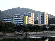
Chun Shek Estate, with Beacon Hill in the background.
Beacon Hill (Chinese: 煙墩山 or Chinese: 筆架山; Cantonese Yale: Pat Ka Shan) is a hill in the northern part of Kowloon peninsula in Hong Kong. It is the 65th highest hill of Hong Kong. It is 457 m tall.
Beacon Hill is located within the Lion Rock Country Park.
The tower atop Beacon Hill is not open to the public, and is a facility maintained by the Hong Kong Civil Aviation Department.[1]
Name
The name dates back to the Great Clearance (1661–1669), which required the evacuation of the coastal areas of in order to fight the anti-Qing movement, begun by Ming Dynasty loyalists. Garrisons were stationed to enforce the decree, in locations called beacons.[2]
See also
| Wikimedia Commons has media related to Beacon Hill, Hong Kong. |
- Geography of Hong Kong
- List of mountains, peaks and hills in Hong Kong
- Beacon Hill School, Hong Kong
References
- ↑ http://www.cad.gov.hk/english/esd_equip.html
- ↑ Andrew Yanne, Gillis Heller (2009). Signs of a Colonial Era. Hong Kong University Press. p. 119. ISBN 978-962-209-944-9.
Coordinates: 22°20′59″N 114°10′13″E / 22.349701°N 114.170144°E
This article is issued from Wikipedia - version of the 11/14/2016. The text is available under the Creative Commons Attribution/Share Alike but additional terms may apply for the media files.