Beardsley Dam
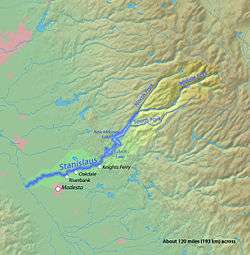
Beardsley Dam (National ID # CA00263) is a dam on the Middle Fork Stanislaus River in Tuolumne County, California. The site is surrounded by the Stanislaus National Forest.
Water and power
The earthen dam was completed in 1957 with a height of 284 feet (87 m), and a length of 1,000 feet (300 m) at its crest.[1] It impounds the Middle Fork of the Stanislaus River for hydroelectric power and irrigation water storage, part of the Stanislaus River Tri-Dam project cooperatively owned by the Oakdale Irrigation District and South San Joaquin Irrigation District.[2]
The reservoir it creates, Beardsley Lake, has a water surface of 1.1 square miles, a maximum capacity of 97,800 acre feet (120,600,000 m3), and a normal capacity of 97,500 acre feet (120,300,000 m3).[3] Recreation includes camping, fishing, and boating.[4]
See also
- List of dams and reservoirs in California
- Stanislaus River topics
References
- ↑ "Archived copy". Archived from the original on 2014-09-04. Retrieved 2012-09-23.
- ↑ http://tridamproject.com/tridam.aspx
- ↑ http://findlakes.com/beardsley_california~ca00263.htm
- ↑ http://tridamproject.com/beardsley.aspx
Coordinates: 38°12′15″N 120°04′28″W / 38.20425°N 120.07447°W