Stanislaus National Forest
| Stanislaus National Forest | |
|---|---|
|
IUCN category VI (protected area with sustainable use of natural resources) | |
|
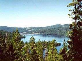
Cherry Lake in Stanislaus National Forest | |
 | |
| Location | California, United States |
| Nearest city | Sonora, California |
| Coordinates | 38°15′01″N 120°00′01″W / 38.25028°N 120.00028°WCoordinates: 38°15′01″N 120°00′01″W / 38.25028°N 120.00028°W |
| Area | 898,099 acres (3,634 km2) |
| Established | February 22, 1897 |
| Governing body | U.S. Forest Service |
| Website | Stanislaus National Forest |
Stanislaus National Forest is a United States national forest which manages 898,099 acres (1,403.3 sq mi; 3,634.5 km2) of land in four counties in the Sierra Nevada Mountains of Northern California. It was established on February 22, 1897, making it one of the oldest national forests. It was named after the Stanislaus River.
Geography

The forest is located primarily in eastern Tuolumne County, adjacent to the northwestern part of Yosemite National Park, but parts of it extend (in descending order of forestland area) into southern Alpine, northern Mariposa, and eastern Calaveras counties. Forest headquarters are located in Sonora, California. There are local ranger district offices in Groveland, Hathaway Pines, Mi-Wuk Village, and Pinecrest.[1]
The Emigrant Wilderness is located entirely within its boundaries. Portions of the Carson-Iceberg Wilderness, including the Dardanelles Cone, and the Mokelumne Wilderness are also within the Stanislaus National Forest.
Features
It contains 78 lakes, and 811 miles (1,305.2 km) of rivers and streams. It has 1,100 miles (1,770.3 km) of non-motorized trails, and 2,859 miles (4,601.1 km) of roads, 188 miles (302.6 km) of which are paved.

The Forest contains some 139,000 acres (560 km2) of old growth, which includes Lodgepole Pine (Pinus contorta), Jeffrey Pine (Pinus jeffreyi), and White Fir (Abies concolor).[2]
Recreation
The proximity of the Stanislaus National Forest to the San Francisco Bay area makes it a popular recreation destination. The stunning volcanic and granite formations in the wilderness are somewhat marred by the heavy cattle grazing, a shock to many backpackers. Exceptional whitewater rafting and kayaking can be found in the wild and scenic Tuolumne River and Cherry Creek. Other beautiful rivers flowing out of the Stanislaus include the Clavey River the Stanislaus River, and the Merced River along the southern boundary.
Two ski resorts Dodge Ridge and Bear Valley operate here under a special use permit.
Rim Fire
The Rim Fire was ignited on the Stanislaus National Forest in August 2013, and eventually grew to become the third-largest fire in California history. The fire was named after the Rim of the World Vista on California State Route 120, where the fire was initially reported.
See also
- Ecology of the Sierra Nevada
- List of plants of the Sierra Nevada (U.S.)
- Index: Fauna of the Sierra Nevada (U.S.)
- Calaveras Big Tree National Forest - historical
References
- ↑ USFS Ranger Districts by State
- ↑ Warbington, Ralph; Beardsley, Debby (2002), 2002 Estimates of Old Growth Forests on the 18 National Forests of the Pacific Southwest Region, United States Forest Service, Pacific Southwest Region
External links
| Wikimedia Commons has media related to Category:Stanislaus National Forest. |