Belvoir Township, Pitt County, North Carolina
| Belvoir Township | |
|---|---|
| Township | |
| Coordinates: 35°42′29″N 77°27′54″W / 35.708°N 77.465°WCoordinates: 35°42′29″N 77°27′54″W / 35.708°N 77.465°W | |
| Country | United States |
| State | North Carolina |
| County | Pitt |
| Area | |
| • Total | 55.2 sq mi (142.9 km2) |
| • Land | 54.7 sq mi (141.8 km2) |
| • Water | 0.4 sq mi (1.0 km2) |
| Elevation | 36 ft (12 m) |
| Population (2010) | |
| • Total | 9,334 |
| • Density | 170/sq mi (65/km2) |
| Time zone | Eastern (EST) (UTC-5) |
| • Summer (DST) | EDT (UTC-4) |
| ZIP code | 27834 |
| Area code(s) | 252 |
| FIPS code | 37-22640[1] |
| GNIS feature ID | 1020208[2] |
Belvoir Township is a township in Pitt County, North Carolina, United States. The population was 9,334 at the 2010 census. The township is a part of the Greenville Metropolitan Area located in North Carolina's Inner Banks region. It includes the census-designated place of Belvoir, North Carolina.
Geography
Belvoir is located at latitude 35.708 and longitude -77.465.
According to the United States Census Bureau, the town has a total area of 55.2 square miles (142.9 km2), of which 54.7 square miles (141.8 km2) is land and 0.39 square miles (1.0 km2), or 0.72%, is water.
Demographics
As of the census[1] of 2010, there were 9,334 people living in the township. The racial makeup of the town was 30.7% White, 51.5% African American, 0.5% American Indian or Alaska Native, 0.4% Asian, 0.3% Native Hawaiian or other Pacific Islander, 13.5% from some other race, and 3.1% from two or more races. Hispanic or Latino of any race were 19.3% of the population.
In the town the population was spread out with 30.3% under the age of 18, 9.4% from 18 to 24, 27.5% from 25 to 44, 24.5% from 45 to 64, and 8.3% who were 65 years of age or older. The median age was 32.4 years. Males made up 48.8% of the population, and females made up 51.2%.
At the 2000 census, the median income for a household in the town was $36,149, and the median income for a family was $46,549.
References
- 1 2 "American FactFinder". United States Census Bureau. Archived from the original on 2013-09-11. Retrieved 2008-01-31.
- ↑ "US Board on Geographic Names". United States Geological Survey. 2007-10-25. Retrieved 2008-01-31.
Municipalities and communities of Pitt County, North Carolina, United States | ||
|---|---|---|
| City | 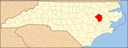 | |
| Towns | ||
| CDPs | ||
| Unincorporated communities | ||
| Footnotes | ‡This populated place also has portions in an adjacent county or counties | |