Benešov
- See other locations named Benešov.
| Benešov | |||
| Town | |||
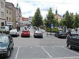 Masaryk Square | |||
|
|||
| Country | Czech Republic | ||
|---|---|---|---|
| Region | Central Bohemian | ||
| District | Benešov | ||
| Elevation | 360 m (1,181 ft) | ||
| Coordinates | CZ 49°46′58″N 14°41′19″E / 49.78278°N 14.68861°ECoordinates: CZ 49°46′58″N 14°41′19″E / 49.78278°N 14.68861°E | ||
| Area | 46.87 km2 (18.10 sq mi) | ||
| Population | 16,573 (As of 2015) | ||
| Density | 354/km2 (917/sq mi) | ||
| Founded | 11th century | ||
| Mayor | Petr Hostek | ||
| Postal code | 256 01 | ||
  Location in the Czech Republic
| |||
| Wikimedia Commons: Benešov | |||
| Website: www.benesov-city.cz | |||

Benešov (Czech pronunciation: [ˈbɛnɛʃof]; German: Beneschau) is a town in the Central Bohemian Region, Czech Republic, about 40 kilometres (25 mi) southeast of Prague. The Konopiště castle and the Czech national mountain Blaník are near the town. 1 January 2013 population of 16 541 was recorded .
History
Benešov began to be settled in the 11th century. The first settlers are believed to have arrived on Karlov Hill in 1050 during the Přemyslid dynasty. A message from the 17th century points to an existing church in 1070. The first written mention of Benešov, then spelt Benissaw in Latin, however, dates only from 1226, when it was owned by the Lord of Benis, as the surname was then spelt. A small monastery was founded here in 1246 by Tobias of Benissaw, the Prague provost and an uncle of the late Bishop of Prague, Tobias of Bechyne. By 1300 they left and the property was sold to the Lord of Sternberg, whose crest is still the city's coat of arms. In 1420 the then mostly German populated city was conquered and burned by the Hussites.
In the late Middle Ages Benissaw was the centre of several political negotiations, such as the 1451 and 1473 meetings of the Bohemian Diet here. In the 15th and 16th centuries the town experienced an economic boom, especially thanks to its location on the trade route from Prague to Linz. A contemporary first edition map in Latin by A. Ortelius dated 1570 spells the city as Benissaw. After the end of the 16th Century there were several changes in ownership. During the Thirty Years' War, the population had suffered because of passing Polish and Swedish troops. To promote the reintroduction of Catholicism and improving the education a 1703 Priory college with a high school was founded in 1703. The Saint Anna Church of the Priory College was built over 1705 to 1715 according to plans submitted by the Italian architect Giovanni Battista Alliprandi. After 1803 the town developed as a center of national rebirth for Slavic Bohemians.
In 1871 the town was connected to Prague by rail and by 1895 it was an important regional hub. The town's station is Benešov u Prahy.
By World War I Benesov was an important garrison town of the Austro-Hungarian Monarchy. There were the Second Battalion of the II. Bataillon des Böhmischen Infanterie-Regiments Nr. 102 (Bohemian Infantry Regiment No. 102) and the II. Bataillon des k.k. Landwehr-Infanterie-Regiments Nr. 28 (Second Battalion of the Imperial Landwehr Infantry Regiment No. 28). Because of fears of possible political unrest in 1916 by Czech nationalists, the 2nd Regiment of the Tiroler Kaiserjäger with a reserve unit part from Bolzano was stationed here to 1918.
Early during World War II the town was evacuated temporarily as the SS-Truppenübungsplatz Böhmen of the Waffen SS was stationed here.
A significant measure of industrialization began after 1945 with the establishment of a machinery factory and the food industry.
People from Benešov
- Artuš Scheine, (1863, Benešov - 1938) illustrator and painter
- Josef Suk (composer) (1874, Křečovice - 1935, Benešov)
External links
| Wikimedia Commons has media related to Benešov. |