Beni Ourtilane District
| Béni Ourtilane District دائرة بني ورتيلان | |
|---|---|
| District | |
|
Beni Ourtilane | |
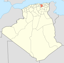 Map of Algeria highlighting Sétif Province | |
| Coordinates: 36°26′N 4°54′E / 36.433°N 4.900°ECoordinates: 36°26′N 4°54′E / 36.433°N 4.900°E | |
| Country |
|
| Province | Sétif |
| District seat | Béni Ourtilane |
| Area | |
| • Total | 73 km2 (28 sq mi) |
| Population (1992) | |
| • Total | 12,022 |
| • Density | 160/km2 (430/sq mi) |
| Time zone | CET (UTC+01) |
| District code | 19700 |
| Municipalities | 4 |
Béni Ourtilane (or At Wartiran as it is called by its native Kabyle inhabitants) is a district of the Sétif Province in the Petite Kabylie region of Algeria. It is named after its district capital Beni Ouartilene. It is located in the north-western part of the Sétif Province near the border with Béjaïa and Bordj Bou Arreridj. It was originally part of the Sétif Province when Algeria got its independence in 1962 but it became part of the Béjaïa Province in 1975. However, in 1985 it returned to become a part of the Sétif Province.[1]
Municipalities
Béni Ourtilane consists of four municipalities:
- Béni Ourtilane
- Béni Chebana
- Ain Legredj
- Béni Mouhli
Transport
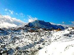
Due to its remote location in the Babor Mountains, Béni Ourtilane is only accessible by one road, National Route 74.
Notable people
- Cheikh Lhocine El Ouartilani
- Cheikh Fodil El Ouartilani
- Yahia Ait Hamoudi ben Abdellah Ait Hamoudi
- Abdellah ben Yahia Ait Hamoudi
References
External links
This article is issued from Wikipedia - version of the 6/21/2016. The text is available under the Creative Commons Attribution/Share Alike but additional terms may apply for the media files.