Benkovac
| Benkovac | |
|---|---|
| Town | |
|
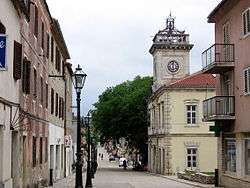
Street in Benkovac | |
 Benkovac Location of Benkovac in Croatia | |
| Coordinates: 44°02′04″N 15°36′46″E / 44.03444°N 15.61278°E | |
| Country |
|
| County |
|
| Government | |
| • Mayor | Branko Kutija (HDZ) |
| Area | |
| • Total | 514 km2 (198 sq mi) |
| Population (2011)[1] | |
| • Total | 11,026 |
| Time zone | CET (UTC+1) |
| • Summer (DST) | CEST (UTC+2) |
| Website |
www |
Benkovac (pronounced [běːnkovat͡s]) is a town and municipality in the interior of Zadar County, Croatia.
Geography
Benkovac is located where the plain of Ravni Kotari and the karstic plateau of Bukovica meet, 20 km from the town of Biograd na Moru and 30 km from Zadar. The Zagreb-Split motorway and Zadar-Knin railway pass through the town. It borders the municipalities of Novigrad, Posedarje, Obrovac, Lišane Ostrovičke, Kistanje and Stankovci.
Demography
According to the 2011 census, the municipality had 11,026 inhabitants of which 84.9% were Croats and 13.8% were Serbs.[1] Before the Croatian War of Independence, Serbs made up about 57%, and Croats about 41%, however Croats only held 18% of the jobs in the local government,[2] which led to high tensions in the 1990s. During the Operation Storm (Oluja), almost all of the Serbs left the town,[3] and after the war they were replaced by expelled Bosnian Croat settlers.
According to the Austrian Census in 1900, the town of Benkovac consisted of 356 Catholics and 156 Orthodox, with area surrounding Benkovac it included 8,119 Catholics and 5,981 Orthodox. The 1910 census recorded a total of 810 residents, 388 of which were Catholic and 422 Orthodox. Both censuses were conducted according to religion and language (Serbo-Croatian). The population of Benkovac itself is 2,622 (census 2001), the rest is distributed in 38 villages surrounding it.
History


The first traces of human life in the Benkovac area were found around the village of Smilčić that belonged to the Danilo culture. Before Roman conquest the area was inhabited by the Illyrian tribe of Liburnians. During the Roman Civil war the Liburnians sided with Caesar. The Romans mention the following Liburnian settlements :Nedinum (Nadin), Carinium (Karin), Varvaria (Bribir) and Asseria (Podgrađe). In 7th century the area was settled by Croats. The area of Benkovac was at the crossroads of four Croatian župas - Novljanska, Sidraška, Bribirska and Karinska. Near the village of Šopot, an inscription from the 9th century was found that mentions Branimir as a Croatian Duke.
In 1409 King Ladislaus of Naples sold his rights of Dalmatia to the Republic of Venice and the Benkovac area became a border region. New fortresses around the border were built - Korlat, Kličevica, Polača, and behind them Benković i Perušić. The fortress of Benković was named after the family of nobles that built it and the city of Benkovac was established. In 1527 Benkovac became part of the Ottoman Empire. It was settled by Croats-Bunjevci, Serbs and Vlachs.
In October 1683, the population of Venetian Dalmatia, principally Uskoks of Ravni kotari, took arms and together with the rayah (lower class) of the Ottoman frontier regions rose up, taking Skradin, Karin, Vrana, Benkovac and Obrovac.[4] It became part of the Republic of Venice following the Morean War.
Until 1918, the town (with bilingual name BENKOVAC - BENCOVAZ) was part of the Austrian monarchy in the district of the same name, one of 13 Bezirkshauptmannschaften in Dalmatia.[5] The name was BENCOVACZ before 1867.[6]
From 1929 to 1939, Benkovac was part of the Littoral Banovina and from 1939 to 1941 of the Banovina of Croatia within the Kingdom of Yugoslavia. The area was bombed by the Allies during World War II.[7]
During the Croatian War of Independence, Benkovac was a center of unrest and hostilities between Croats and Serbs. On 17 March 1990, tensions erupted when groups of local Serbs rebelled against the decision of the government to disarm local police in which Serbs were most of the employees. During that time the provincial Croatian government continued arming police forces and paramilitaries in villages with ethnic Croat majorities. Tensions continued to boil, and five months later, Benkovac was included in the Republic of Serbian Krajina. Five years later on 5 August 1995, Benkovac was retaken by the Croatian army during Operation Storm.
Towns and villages
The following settlements are part of Benkovac:[8]
- Benkovac (population 2,622)
- Benkovačko Selo (population 524)
- Bjelina (population 50)
- Brgud (population 3)
- Bruška (population 167)
- Buković (population 323)
- Bulić (population 172)
- Dobra Voda (population 114)
- Donje Biljane (population 13)
- Donje Ceranje (population 43)
- Donji Karin (population 101)
- Donji Kašić (population 4)
- Donji Lepuri (population 151)
- Gornje Biljane (population 59)
- Gornje Ceranje (population 61)
- Islam Grčki (population 108)
- Kolarina (population 13)
- Korlat (population 373)
- Kožlovac (population 8)
- Kula Atlagić (population 151)
- Lisičić (population 268)
- Lišane Tinjske (population 15)
- Medviđa (population 199)
- Miranje (population 86)
- Nadin (population 439)
- Perušić Benkovački (population 297)
- Podgrađe (population 106)
- Podlug (population 227)
- Popovići (population 209)
- Pristeg (population 368)
- Prović (population 84)
- Radošinovci (population 266)
- Raštević (population 420)
- Rodaljice (population 80)
- Smilčić (population 250)
- Šopot (population 271)
- Tinj (population 551)
- Vukšić (population 462)
- Zagrad (population 103)
- Zapužane (population 25)
References
- 1 2 "Population by Ethnicity, by Towns/Municipalities, 2011 Census: County of Zadar". Census of Population, Households and Dwellings 2011. Zagreb: Croatian Bureau of Statistics. December 2012.
- ↑ Tanner, Marcus. Croatia: A nation forged in war. Yale University Press, 1997.
- ↑ ICTY - Gotovina Case - Judgement Summary p. 3
- ↑ Radovan Samardžić (1990). Seobe srpskog naroda od XIV do XX veka: zbornik radova posvećen tristagodišnjici velike seobe Srba. Zavod za udžbenike i nastavna sredstva.
Становништво Млетачке Далмације, на првом месту Котарски ускоци, још у октобру 1683. дигло се на оружје заједно с ра- јом у пограничним крајевима Турске. Устаници су "сами заузели Скрадин, Карин, Врану, Бенковац и Обровац
- ↑ Wilhelm KLEIN (1967), "Die postalischen Abstempelungen auf den österreichischen Postwertzeichen-Ausgaben 1867, 1883 und 1890".
- ↑ Edwin MUELLER (1961), Handbook of Austria and Lombardy-Venetia Cancellations on the Postage Stamp Issues 1850-1864..
- ↑ Orao njivu u Nadinu pa naišao na avionsku bombu Archived March 25, 2009, at the Wayback Machine., vecernji.hr; accessed 22 April 2015.
- ↑ http://www.dzs.hr/hrv/censuses/census2001/Popis/H01_01_03/h01_01_03_zup13-0175.html
External links
| Wikimedia Commons has media related to Benkovac. |
Subdivisions of Zadar County | ||
|---|---|---|
| Cities and towns |  | |
| Municipalities | ||
Coordinates: 44°02′04″N 15°36′46″E / 44.03444°N 15.61278°E