Bermersheim vor der Höhe
| Bermersheim vor der Höhe | ||
|---|---|---|
| ||
 Bermersheim vor der Höhe | ||
Location of Bermersheim vor der Höhe within Alzey-Worms district 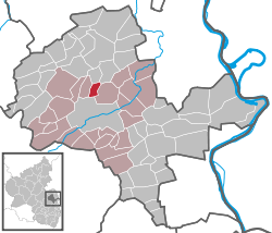 | ||
| Coordinates: 49°40′55″N 8°13′25″E / 49.68194°N 8.22361°ECoordinates: 49°40′55″N 8°13′25″E / 49.68194°N 8.22361°E | ||
| Country | Germany | |
| State | Rhineland-Palatinate | |
| District | Alzey-Worms | |
| Municipal assoc. | Alzey-Land | |
| Government | ||
| • Mayor | Werner Wagner | |
| Area | ||
| • Total | 2.87 km2 (1.11 sq mi) | |
| Population (2015-12-31)[1] | ||
| • Total | 380 | |
| • Density | 130/km2 (340/sq mi) | |
| Time zone | CET/CEST (UTC+1/+2) | |
| Postal codes | 55234 | |
| Dialling codes | 06731 | |
| Vehicle registration | AZ | |

Bermersheim vor der Höhe is an Ortsgemeinde – a municipality belonging to a Verbandsgemeinde, a kind of collective municipality – in the Alzey-Worms district in Rhineland-Palatinate, Germany.
Geography
Location
As a winegrowing centre, Bermersheim vor der Höhe lies in Germany’s biggest winegrowing district, in the middle of Rhenish Hesse. It belongs to the Verbandsgemeinde of Alzey-Land, whose seat is in Alzey.
History
The earliest documentary evidence of the name of Bermersheim dates from the year 768, in connection with the sale of an estate to Lorsch Abbey.
The words vor der Höhe (meaning “before the Heights”) were added to the name with effect from 1 April 1971.
Politics
Municipal council
The council is made up of 8 council members, who were elected by proportional representation at a municipal election held on 7 June 2009, with the honorary mayor as chairman.
The municipal election held on 7 June 2009 yielded the following results:[2]
| SPD | FWG 1 | FWG 2 | Total | |
| 2009 | 2 | 5 | 1 | 8 seats |
Mayors
- Volker Herberg (.... - 2004)
- Werner Wagner (2004–present)
Culture and sightseeing
Buildings
- In Bermersheim vor der Höhe is found Hildegard of Bingen’s baptismal church.