Besso (mountain)
| Besso | |
|---|---|
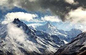 Besso (left), with the Ober Gabelhorn (right) | |
| Highest point | |
| Elevation | 3,668 m (12,034 ft) |
| Prominence | 149 m (489 ft) [1] |
| Parent peak | Weisshorn |
| Coordinates | 46°4′39.43″N 7°39′31.5″E / 46.0776194°N 7.658750°ECoordinates: 46°4′39.43″N 7°39′31.5″E / 46.0776194°N 7.658750°E |
| Geography | |
 Besso Location in Switzerland | |
| Location | Valais, Switzerland |
| Parent range | Pennine Alps |
| Climbing | |
| First ascent | c. 1862 by J. B. Epinay and J. Vianin |
| Easiest route | South flank and south-east ridge (F) |
Besso (3667 m) is a mountain in the Pennine Alps in the Swiss canton of Valais.
The name Besso means 'twins' in the dialect of the Val d'Hérens and refers to the twin summits of the mountain.
The first ascent of the mountain was probably made by the guides J. B. Épinay and J. Vianin in 1862.[2] The classic route on the mountain – the south-west ridge (PD+) – was, according to Collomb, 'possibly' first climbed by R. L. G. Irving and party in 1906.[3]
The Mountet hut (2,886 m) is used for the normal route, which is known as the 'Ladies' Route'.
References
External links
This article is issued from Wikipedia - version of the 7/15/2016. The text is available under the Creative Commons Attribution/Share Alike but additional terms may apply for the media files.