Bidasoa
| Bidasoa | |
|---|---|
 Bidasoa River (in Spain) | |
| Country | Spain, France |
| Basin | |
| Main source | Western Pyrenees |
| River mouth |
Bay of Biscay 43°22′22″N 1°47′31″W / 43.37278°N 1.79194°WCoordinates: 43°22′22″N 1°47′31″W / 43.37278°N 1.79194°W |
| Basin size | 705 km2 (272 sq mi)[1] |
| Physical characteristics | |
| Length | 66 km (41 mi)[1] |
| Discharge |
|
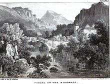
The Bidasoa (Basque: [bidasoa], Spanish: [biðaˈsoa]; French: Bidassoa) is a river in the Basque Country of northern Spain and southern France that runs largely south to north. Named as such downstream of the small town of Oronoz-Mugairi (municipality of Baztan) in the province of Navarre, the river actually results from the merge of several streams near the village Erratzu, with the stream Baztan that rises at the north-eastern side of the mount Autza (1,306 m) being considered the source of the Bidasoa. It joins the Cantabrian Sea (Bay of Biscay) between the towns of Hendaye and Hondarribia.
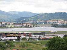
The river is best known for establishing the borderline at its lower tract.[2] This stretch is crossed not only by aircraft at low height but by important European communication axes, namely AP8 E5 E80 - E70 A63 (motorway, connection at the Biriatu toll), main roads N1 - N10 (connection at the roundabout of Saizar by the river) and major French and Spanish railway networks,[2]—RENFE and SNCF. Besides these major lines, other regional ones cross it too, e.g. regional railway EuskoTren (terminus in Hendaye)[2] and another double bridge (pedestrians/vehicles) joining the towns on the border, i.e. the historical Santiago Bridge (Way of St. James). At this stage of the river, urban landscape prevails (built-up area).
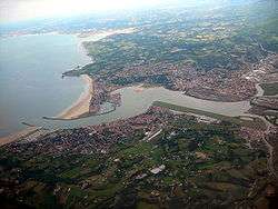
Before pouring its waters into the ocean, it forms a bay called Txingudi located between these towns and Irun,[2] the site being designated Wetland of International Importance in 2002, with a total area of 1.28 km2. The banks of Hondarribia hold the minor San Sebastian Airport serving domestic flights[2] and currently mired in controversy over its lengthening and upgrading scheme.
Pronunciation and etymology
The river comprises an area of linguistic contact, so it is pronounced differently depending on the language, namely [biˈdas̺oa] in Basque, [biðaˈsoa] in Spanish, and [bidasoa] in French. Linguistic and historic research point to the name stemming from Latin phrase "Via ad Oiassonem" (later corrupting into Basque Bidasoa) on account of the road that linked at Roman times Basque town Pompaelo with Oiasso, which may have run along the river.
Course of the river and tributaries
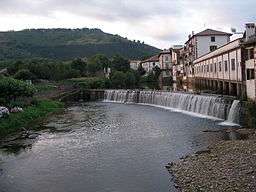
The Bidasoa flows through much of its 66 km length over Navarrese territory, except for the last 10 km, where it establishes the borderline between France and Spain, as well as the boundary between the Basque provinces of Gipuzkoa and Labourd. In line with the distribution of the river's length, the bulk of its watershed's area lies on Navarre (684 km2). The basin holds 105 permanent streams and rivers that number 497 km, the region being drenched in rains regularly. The Navarrese side of the basin (rural landscape) is inhabited by 22,000 inhabitants. 70% of its population have the sewage treated before spilling to the river.
But for the first 15-odd kilometres, the river clings to the north to south disposition of other neighbouring rivers of Gipuzkoa joining the Bay of Biscay, e.g. Urumea, Oria, etc. Strengthened by the waters harvested from the sides of the pass of Belate, downstream of Doneztebe the river heads north and crosses the town of Bera at the north end of Navarre before entering Gipuzkoa at Endarlatsa. From the town of Doneztebe on, the main road N-121 runs along till the roundabout across the river from the toll of Biriatu by the AP-8 (motorway). Next comes the quarter Behobia and the major towns on the shores of the estuary.
The main tributaries of the Bidasoa are the minor rivers Zeberia (length 10,80 km), Ezkurra (20,90 km), Latsa (11,10 km) and Endara (9,90 km). Additionally, further small rivers and streams feed the Bidasoa all along.
Fishing and environmental challenges
The Navarrese tract of the river is a preferred destination for fishing enthusiasts, the river being home to several native fish species, namely eel (Anguilla anguilla), salmon (Salmo palar), trout (Salmo trutta), bullhead (Cottus gobio), Barbatula barbatula, Phoxinus phoxinus, gudgeon (Gobio lozanoi), sea lamprey (Petromyzon marinus), allis shad (Alosa alosa), flounder (Platichthys flesus) and grey mullet (Chelon labrosus), some of them declared endangered species and highly interesting (especially bullhead and salmon).[3] Moreover, a species of the Ebro, i.e. Chondrostoma miegii, has been introduced in the last 30–40 years on the lower tract of the Bidasoa, thereafter extending gradually upstream.
As a result, overfishing has become a major problem for the river's fauna, with special pressure put on salmon migrating upstream to spawn. They don't make it to their goal and die before spawning, either falling prey to fishers' bait or an inability to overcome hydroelectric power stations (128 over all the course) and the 114 related dams, since 63% of them prevent migratory fish from achieving their purpose. Schemes by the Regional Government of Navarre are underway with a view to handling the issue.
See also
Footnotes
- 1 2 "Ríos: Río Bidasoa". Inst. Geográfico Vasco Andres Urdaneta Euskal Geografi Elkargoa. Retrieved 20 October 2013.
- 1 2 3 4 5 "Comarca del Bajo Bidasoa (Bidasoa Beherea)". Inst. Geográfico Vasco Andres Urdaneta Euskal Geografi Elkargoa. Retrieved 20 October 2013.
- ↑ "RED DE SEGUIMIENTO DEL ESTADO ECOLÓGICO DE LOS RÍOS DE LA COMUNIDAD AUTÓNOMA DEL PAÍS VASCO: Tomo 15, Unidad Hidrológica del Bidasoa" (PDF). Ingurumena. EJ-GV. 2005. Retrieved 20 October 2013.
References
- Report on the Environmental State of the Bidasoa River by the Basque Regional Govt (site in Spanish)
- Report for Correction Measures on the Bidasoa (link to Pdf, site in Spanish)
- Briefing on the Bidasoa by an Agency of the Navarrese Regional Govt (site in Spanish)
- Geographical descriptive account of the Lower Bidasoa region by Geological Research Agency (site in Basque)
- The Bidas(s)oa at the Sandre database (site in French)
| Wikimedia Commons has media related to Bidassoa. |