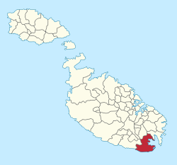
Birżebbuġa
| Birżebbuġa | |||
|---|---|---|---|
| Local council | |||
|
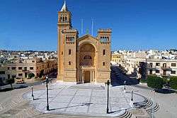
Birżebbuġa Parish Church | |||
| |||
|
Motto: Pax Salusque Omnibus (Peace and Health to Everyone) | |||
 | |||
| Coordinates: 35°49′32″N 14°31′41″E / 35.82556°N 14.52806°ECoordinates: 35°49′32″N 14°31′41″E / 35.82556°N 14.52806°E | |||
| Country |
| ||
| Region | Southern Region | ||
| District | South Eastern District | ||
| Borders | Għaxaq, Marsaxlokk, Żurrieq, Luqa | ||
| Government | |||
| • Mayor | Kevin Barun (PL) | ||
| Area | |||
| • Total | 9.2 km2 (3.6 sq mi) | ||
| [1] | |||
| Elevation | 20 m (70 ft) | ||
| Population (March 2014) | |||
| • Total | 9,736 | ||
| • Density | 1,100/km2 (2,700/sq mi) | ||
| Demonym(s) | Birżebbuġi (m), Birżebbuġija (f), Birżebbuġin (pl) | ||
| Time zone | CET (UTC+1) | ||
| • Summer (DST) | CEST (UTC+2) | ||
| Postal code | BBG | ||
| Dialing code | 356 | ||
| ISO 3166 code | MT-05 | ||
| Patron saint | St. Peter in Chains | ||
| Day of festa | 1st Sunday of August | ||
| Website | Official website | ||


Birżebbuġa (B'Buġa), sometimes spelt Birzebbugia (B'Bugia),[2] is a seaside town in the Southern Region of Malta, close to Marsaxlokk. It is approximately 8 miles (13 kilometres) from the capital Valletta, and it has a population of 9,736 as of March 2014.[3]
The town is popular among Maltese holiday makers, and it known for its sandy beach, Pretty Bay. The village is also notable for its important archaeological sites, especially Għar Dalam and Borġ in-Nadur.
Etymology
"Birżebbuġa" means "well of olives" in the Maltese language. Such linguistic evidence established early inhabitants were in the south of the island since the first millennium. The name also indicates climate and food.
History
Prehistory

Near the village of Birżebbuġa is Għar Dalam, meaning a dark cave. Għar Dalam Cave is a highly important site, as it was here that the earliest evidence of human presence on Malta was discovered. Artifacts date back to the Neolithic Period some 7,400 years ago. The display area consists of two parts: the cave and the museum, which exhibits a remarkable wealth of finds from animal bones to human artifacts. An overlaying river running at right angles formed the cave. It is some 144 metres deep, but only the first fifty metres are open to visitors.
The lowermost layers, more than 500,000 years old, contain the fossil bones of dwarf elephants, hippopotami, micro-mammals and birds. Above the pebble layer is the so-called ‘deer’ layer, dated to around 18,000 years ago. The top layer dates to less than 10,000 years and holds evidence of the first humans on the Island. Experts hold that these remains suggest that the Islands were once a land bridge to continental Europe.
Other remains include those of a prehistoric temple or settlement, Borġ in-Nadur, which dates from the Bronze Age. The settlement was fortified with a large stone wall, still visible today. These temple ruins are important because they reveal not only a four-apse temple (c.2000 BC), but an authentic, fortified Bronze Age domestic settlement. The remains of a large, defensive wall lie nearby, running across the head of a promontory between two valleys leading down to two bays. The wall was built facing inland. The village would have had the sea to its back. This logistic situation leads scholars to believe that the people living in the village were more afraid of being attacked by invaders by land rather than from the sea.
Traces of Bronze Age huts were discovered lying just behind the wall. The depth of the deposits was very shallow, covering the remains of the Temple Period. Archaeologists have found evidence that shows that the Neolithic population became extinct and the islands were uninhabited. Archaeologists think that this could have been due to no agricultural produce, civil warfare, or the Neolithic population being murdered by war-like tribes. Archaeologists have uncovered the remains of the three apses (semi-circular rooms) of the temple. Beyond the main entrance, there is a wide elliptical area about 25 m long and 15 m wide. Only the Trilithon Entrance remains. Visits to these sites can be arranged by appointment.
Birżebbuġa also has Cart Ruts that lead into the sea and run along the sea floor.
Modern history
In addition to prehistoric sites, the town includes historical structures and remains that date back centuries, revealing changing peoples as the island went through different periods of domination by various political interests. Such structures include Ferretti Battery, Pinto Battery, and the Birżebbuġa entrenchments. These sites date back to the rule of the Order of Saint John, who ruled the Maltese islands from 1530 to 1798. Napoleon ejected the Order from Malta, and later the island came under Great Britain.
During the British period, Fort Benghisa, RAF Kalafrana and RAF Hal Far were built in Birżebbuġa.
Churches tell part of the history of the town:
- St George's Church (1575, reopened in 1683). In the earth nearby are traces of prehistoric cart ruts.
- the Chapel of the Good Shepherd,
- the Immaculate Conception Church at Bengħisa (1822, enlarged in 1862),
- the Holy Family Chapel (1865),
- the Chapel of Our Lady Help of Christians (1839), private;
- St Joseph’s Chapel (1871), private; and
- the Church of Our Lady of Sorrows (1909), which served as parish church until 1938. Birżebbuġa became a formal parish on 9 September 1913, with a resident priest. Some time later, the parish worked to build a larger church. St. Peter in Chains opened for worship on 12 June 1938. The present parish priest is Rev. Can. Fr Anton Galea-Scannura.
During the last decade, there has been an influx of new workers employed at the nearby Malta Freeport and container terminal. In addition, new residents have come from the neighbouring villages, Birzebbuġa now hosts some 10,000 people.
The town is built around the beach, which puts it close to many shops and restaurants along the coastline. Some vacationers prefer the rocky shore in the neighbouring St George's Bay, ideal for sun bathing and snorkeling. Sailing is popular throughout the year. St George's Bay is also used by local fishermen who moor their boats at the inlet. St George's Bay is famous for its Cart Ruts that go across the small sandy Bay.
Transport

To get to Birzebbuga from Valletta you will have to board either the 82, 80 or X4 bus. The X4 passes every 30 minutes to Birzebbuga, 80 every one hour and 82 passes every 15 minutes.
Coat of arms
Birżebbuġa's coat of arms shows a blue chevron and olive branch on a white field. The blue represents the nearby waters of the Mediterranean Sea and the olive branch the major importance of olives to the local economy, in former times.
Sports
The locality hosts a number of football teams. Birżebbuġa St. Peter's F.C. nowadays plays in the Maltese First Division after languishing at the bottom of Maltese football for years. As well as its Seniors' team, the club also possesses a prosperous nursery which is run by Birzebbuga Windmills FC. Birzebbuga St. Peters' is also in a collaboration with a newly found futsal team, Birzebbuga St. Peters' FC Futsal, which is competing in the Maltese Futsal Fourth Division Section A as of 2011. Apart from these clubs, an amateur football team is also present, Birzebbuga Tigers FC.
Zones in Birżebbuġa
- Bengħisa
- Borġ in-Nadur
- Brolli
- Girgħien
- Għar Dalam
- Għar Ħasan, limits of Ħal Far
- Ħal Far
- Kalafrana
- L-Arblu, limits of Ħal Far
- L-Artal, limits of Ħal Far
- L-Imwadar, limits of Bengħisa
- Pretty Bay (Il-Bajja s-Sabiħa)
- Qajjenza
- St. George's Bay (Bajja San Ġorġ)
- Ta' Ġiliġejla, limits of Bengħisa
- Ta' Salvun, limits of Ħal Far
- Ta' Sansajna
- Ta' Żgħer, limits of Ħal Far
- Tal-Għawejra, limits of Ħal Far
- Tal-Papa
- Tax-Xerriek
- Wied Dalam
- Wied il-Buni
- Wied ix-Xoqqa, limits of Bengħisa
- Wied Qoton
- Wied Żembaq
- Wied Żnuber, limits of Ħal Far
- Xoqqiet, limits of Bengħisa
Twin towns
References
- ↑ "Abstract Of Statistics 2000" (PDF). nso.gov.mt. National Statistics Office, Malta. 2003. p. 21. Archived from the original on 16 November 2013. Retrieved 16 November 2013.
- ↑ "Birzebbuga, Malta Page". Falling Rain. Retrieved 23 July 2015.
- ↑ "Estimated Population by Locality 31st March, 2014". Government of Malta. 16 May 2014. Archived from the original on 21 June 2015.
| Wikimedia Commons has media related to Birżebbuġa. |
| Malta Local Councils |
| |
|---|---|---|
| Malta Administrative Committees |
| |
| Gozo Local Councils | ||
| Gozo Administrative Committees | ||