Bishop Bennet Way
| Bishop Bennet Way | |
|---|---|
|
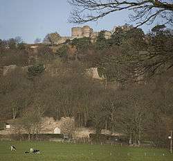
Beeston Castle near start of the route | |
| Length | 34 mi (55 km) |
| Location | Cheshire, England |
| Trailheads |
Beeston Castle 53°07′40″N 2°41′29″W / 53.1277°N 2.6913°W Wirswall 52°59′33″N 2°40′43″W / 52.9924°N 2.6787°W |
| Use | Horse riding, Hiking, Cycling |
The Bishop Bennet Way is a route for horse riding in south west Cheshire, England, which can also be used by walkers and cyclists. It is named after William Bennet (4 March 1745 - 1820), Bishop of Cork and Ross (1790–1794) and subsequently Bishop of Cloyne (1794–1820), who carried out detailed surveys of Roman roads including those between Deva (Chester) and Mediolanum (Whitchurch).[1]
The way starts near Beeston Castle and finishes near Wirswall on the Cheshire-Shropshire border. There are hopes to extend it to Shrewsbury.[1]
The way follows bridle ways, byways and minor roads; half of it is along tarmac roads. Walkers can bypass the longer road sections on footpaths. Cyclists are advised that some parts of the route are difficult for cycling.[1]
The way passes through, or near, Milton Green, Coddington, Shocklach and Grindley Brook.[2]
References
- 1 2 3 "The Bishop Bennet Way" (PDF). Cheshire County Council. Retrieved 2010-07-06.
- ↑ "Bishop Bennet Way". LDWA. Retrieved 2008-06-10.
External links
- Bishop Bennet Way route description
- View Bishop Bennett Way on BHS EMAGIN online map
- Bishop Bennet Way on Long Distance Walkers Association website
- Bishop Bennet Way on Ramblers Association website
- Discovercheshire website (Bishop Bennet Way page)