Shrewsbury
| Shrewsbury | |||
|---|---|---|---|
| County Town | |||
 | |||
| |||
|
Motto: "Floreat Salopia" ("May Shrewsbury Flourish") | |||
 Shrewsbury Shrewsbury shown within Shropshire and England | |||
| Coordinates: 52°42′29″N 2°45′14″W / 52.708°N 2.754°WCoordinates: 52°42′29″N 2°45′14″W / 52.708°N 2.754°W | |||
| Sovereign state | United Kingdom | ||
| Constituent country | England | ||
| Region | West Midlands | ||
| Ceremonial county | Shropshire | ||
| Local government | Shropshire Council | ||
| Website | Shrewsbury Town Council | ||
| Founded | c. 9th century | ||
| Market charter | 1189 | ||
| Administrative HQ | The Shirehall | ||
| Government | |||
| • Type | Town council | ||
| • Governing body | Shrewsbury Town Council | ||
| • UK Parliament | Shrewsbury and Atcham | ||
| • European Parliament | West Midlands | ||
| Elevation | 233 ft (71 m) | ||
| Population (2011) | |||
| • Total | 71,715[1] | ||
| Demonym(s) | Salopian | ||
| Time zone | GMT | ||
| • Summer (DST) | BST (UTC) | ||
| Post codes | SY1, SY2, SY3 | ||
| Area code(s) | 01743 | ||
| Police Force | West Mercia Police | ||
| Fire Service | Shropshire Fire | ||
| Ambulance Service | West Midlands | ||

Shrewsbury (![]() i/ˈʃroʊzbri/ or
i/ˈʃroʊzbri/ or ![]() i/ˈʃruːzbri/)[2][3] is the county town of Shropshire, England. It is on the River Severn and has a population of approximately 72,000.[1]
i/ˈʃruːzbri/)[2][3] is the county town of Shropshire, England. It is on the River Severn and has a population of approximately 72,000.[1]
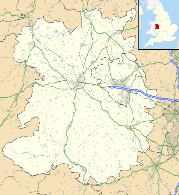
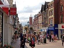
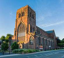
Shrewsbury is a market town whose centre has a largely unaltered medieval street plan and over 660 listed buildings,[4] including several examples of timber framing from the 15th and 16th centuries. Shrewsbury Castle, a red sandstone fortification, and Shrewsbury Abbey, a former Benedictine monastery, were founded in 1074 and 1083 respectively by the Norman Earl of Shrewsbury, Roger de Montgomery.[5] The town has historically been a centre for the wool trade and brewing. Horticulture remains popular, and the Shrewsbury Flower Show is one of the largest horticultural events in England.[6][7][8]
Located 9 miles (14 km) east of the Welsh border, Shrewsbury serves as the commercial centre for Shropshire and mid-Wales, with a retail output of over £299 million per year and light industry and distribution centres, such as Battlefield Enterprise Park, on the outskirts. The A5 and A49 trunk roads cross near to the town, and five railway lines meet at Shrewsbury railway station.
History
Early history

The town was the early capital of the Kingdom of Powys,[9] known to the ancient Britons as Pengwern, signifying "the alder hill";[10] and in Old English as Scrobbesburh (dative Scrobbesbyrig), which may mean either "Scrobb's fort" or "the fortified place in the bushes".[11][12] This name gradually evolved in three directions, into Sciropscire, which became Shropshire; into Sloppesberie, which became Salop/Salopia (an alternative name for both town and county), and into Schrosberie, which eventually became the town's name, Shrewsbury.[10] Its later Welsh name Amwythig means "fortified place".[13]
Over the ages, the geographically important town has been the site of many conflicts, particularly between the English and Welsh. The Angles, under King Offa of Mercia, took possession in 778.
Nearby is the village of Wroxeter, 5 miles (8 km) to the south-east. This was once the site of Viroconium, the fourth largest cantonal capital in Roman Britain. As Caer Guricon it is a possible alternative for the Dark Age seat of the Kingdom of Powys.[14] The importance of the Shrewsbury area in the Roman era was recently underlined with the discovery of the Shrewsbury Hoard in 2009.
Medieval
Shrewsbury's known history commences in the Early Middle Ages, having been founded c. 800 AD. It is believed that Anglo-Saxon Shrewsbury was most probably a settlement fortified through the use of earthworks comprising a ditch and rampart, which were then shored up with a wooden stockade.[15] There is evidence to show that by the beginning of the 900s, Shrewsbury was home to a mint.[15]
The Welsh besieged it in 1069, but were repelled by William the Conqueror. Roger de Montgomery was given the town as a gift from William, and built Shrewsbury Castle in 1074, taking the title of Earl. He founded Shrewsbury Abbey as a Benedictine monastery in 1083. The 3rd Earl, Robert of Bellême, was deposed in 1102 and the title forfeited, in consequence of rebelling against Henry I and joining the Duke of Normandy's invasion of English in 1101.[10] In 1138, King Stephen successfully besieged the castle held by William FitzAlan for the Empress Maud during the period known as the Anarchy.
It was in the late Middle Ages (14th and 15th centuries) when the town was at its height of commercial importance. This was mainly due to the wool trade, a major industry at the time, with the rest of Britain and Europe, especially with the River Severn and Watling Street as trading routes.[16] The Shrewsbury Drapers Company dominated the trade in Welsh wool for many years.[17]
In 1403 the Battle of Shrewsbury was fought a few miles north of the town centre, at Battlefield; it was fought between King Henry IV and Henry Hotspur Percy, with the King emerging victorious,[18] an event celebrated in William Shakespeare's Henry IV, Part 1, Act 5.
Early Modern


Shrewsbury's monastic gathering was disbanded with the Dissolution of the Monasteries and as such the Abbey was closed in 1540. However, it is believed that Henry VIII thereafter intended to make Shrewsbury a cathedral city after the formation of the Church of England, but the citizens of the town declined the offer. Despite this, Shrewsbury thrived throughout the 16th and 17th centuries; largely due to the town's fortuitous location, which allowed it to control the Welsh wool trade. As a resultant a number of grand edifices, including the Ireland's Mansion (built 1575) and Draper's Hall (1658), were constructed. It was also in this period that Edward VI gave permission for the foundation of a free school, which was later to become Shrewsbury School.[19]

During the English Civil War, the town was a Royalist stronghold and only fell to Parliament forces after they were let in by a parliamentarian sympathiser at the St Mary's Water Gate (now also known as Traitor's Gate). After Thomas Mytton captured Shrewsbury in February 1645; in following with the ordnance of no quarter; a dozen Irish prisoners were selected to be killed after picking lots.[20][21] This prompted Prince Rupert to respond by executing Parliamentarian prisoners in Oswestry. Shrewsbury Unitarian Church was founded in 1662. By the 18th century Shrewsbury had become an important market town and stop off for stagecoaches travelling between London and Holyhead on their way to Ireland; this led to the establishment of a number of coaching inns, many of which, such as the Lion Hotel, are extant to this day.
Local soldier and statesman Robert Clive was Shrewsbury's MP from 1762 until his death in 1774. Clive also served once as the town's mayor in 1762.
St Chad's Church collapsed in 1788 after attempts to expand the crypt compromised the structural integrity of the tower above; it was, however, rebuilt just four years later as a large neo-classical round church in a new location close to the Quarry Park.[15]
In the period directly after Napoleon's surrender after Waterloo (18 June 1815), the town's own 53rd (Shropshire) Regiment of Foot was sent to guard him in his exile on St Helena. A locket containing a lock of the emperor's hair (presented to an officer of the 53rd) remains to this day in the collections of the Shropshire Regimental Museum at Shrewsbury Castle.[22]
Late Modern
Shrewsbury has also played a part in Western intellectual history, by being the town where the naturalist Charles Darwin was born and brought up.[23] The town is also home to the Ditherington Flax Mill, the world's first iron-framed building, which is commonly regarded as "the grandfather of the skyscraper". Its importance was officially recognised in the 1950s, resulting in it becoming a Grade I listed building.[24][25] Shrewsbury in the Industrial Revolution was also on the Shrewsbury Canal, which linked it with the Shropshire Canal and the rest of the canal network of Great Britain.[26] Despite this, Shrewsbury escaped much of the industrialisation taking place in 19th century Britain due to its isolation from other large manufacturing towns and ports.
The town suffered very little from the bombing runs in the Second World War that did damage to many English locations. The worst case in Shrewsbury, was in 1940, a woman and her two grandchildren were killed when a cottage was destroyed on Ellesmere Road, the only local air raid deaths.[27] Therefore, many of its ancient buildings remain intact and there was little redevelopment in the 1960s and 1970s, which arguably destroyed the character of many historic towns in the UK. However, a large area of half timbered houses and businesses was destroyed to make way for the Raven Meadows multi-story car park, and other historic buildings were demolished to make way for the brutalist architectural style of the 1960s. The town was saved from a new 'inner ring road' due to its challenging geography.[28]
From the late 1990s the town experienced severe flooding problems from the Severn and Rea Brook. In the autumn of 2000 large swathes of the town were underwater, notably Frankwell, which flooded three times in six weeks.[29] The Frankwell flood defences were completed in 2003, along with the new offices of the borough council. More recently, such as in 2005 and 2007, flooding has been less severe, and the defences have generally held back floodwaters from the town centre areas. However, the town car parks are often left to be flooded in the winter, which reduces trade in the town, most evidenced in the run up to Christmas in 2007.[30]
In 2000 and again in 2002, Shrewsbury unsuccessfully applied for city status.[31]
Shrewsbury won the West Midlands Capital of Enterprise award in 2004.[32] The town has two large expanding business parks, Shrewsbury Business Park by the A5 in the southeast and Battlefield Enterprise Park in the north. There are many residential developments currently under construction in the town to cater for the increasing numbers of people wishing to live in the town, which is a popular place to commute to Telford, Wolverhampton and Birmingham from.[33]
A 2005 report on prison population found that HM Prison Shrewsbury was the most overcrowded in England and Wales.[34] The prison, which was also known as the Dana, was closed in 2013 and then sold by the Ministry of Justice to private property developers in 2014.[35]
In 2009 Shrewsbury Town Council was formed and the town's traditional coat of arms was returned to everyday use.
Geography
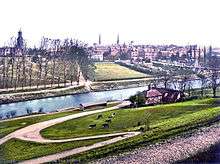
Shrewsbury is about 14 miles (23 km) west of Telford, 43 miles (69 km) west of Birmingham and the West Midlands Conurbation, and about 153 miles (246 km) north-west of the capital, London. More locally, the town is to the east of Welshpool, with Bridgnorth and Kidderminster to the south-east. The border with Wales is 9 miles (14 km) to the west. The town centre is partially built on a hill whose elevation is, at its highest, 246 feet (75 m) above sea level. The longest river in the UK, the River Severn, flows through the town, forming a meander around its centre.[10] The town is subject to flooding from the river.

Belvidere
Monkmoor
Sutton Farm
Porthill
Bicton
Heath Nobold
Castlefields
A clickable link map of Shrewsbury showing suburbs and surrounding villages.
|
The town is near Haughmond Hill, a site where Precambrian rocks, some of the oldest rocks in the county can be found,[36] and the town itself is sited on an area of largely Carboniferous rocks.[37] A fault, the Hodnet Fault, starts approximately at the town, and runs as far as Market Drayton.
Suburbs and metropolitan area
There are a number of suburbs and surrounding villages. The River Severn separates the western, southern and eastern suburbs from the town centre and northern suburbs. An example of a large neighbouring village that has effectively become part of the metropolitan area is Bayston Hill, which grew considerably in the latter half of the 20th century and is now separated from the Meole Brace suburb by only a few fields and the A5 by-pass. It remains, however, a separate entity to the town, with its own parish council, etc. Bayston Hill lies 3 miles (5 km) south of the town centre of Shrewsbury and on the A49 and near to the A5.[38] The smaller village of Battlefield, north of the town, is considered a suburb of the metropolitan area. It is covered by the parish of Shrewsbury.[39]
Climate

The climate of Shrewsbury is similar to that of the rest of Shropshire, generally moderate. Rainfall averages 76 to 100 cm (30 to 39 in), influenced by being in the rainshadow of the Cambrian Mountains from warm, moist frontal systems of the Atlantic Ocean, which bring generally light precipitation in autumn and spring.[40] The nearest weather station is at Shawbury, about 6.5 miles (10.5 km) north-west of Shrewsbury town centre. The local topography, being that of a low-lying plain surrounded by higher ground to the west, south and east gives the Shrewsbury area its own microclimate – the absolute maximum at Shawbury of 34.9 °C (94.8 °F) and absolute minimum of −25.2 °C (−13.4 °F) represents the largest temperature range of any individual weather station in the British Isles – although the maximum range of average temperatures tends to peak to the south east of the Shrewsbury area, particularly in the south east midlands, inland East Anglia and inland south east England.
In an average year, the warmest day is 28.4 °C (83.1 °F),[41] giving a total of 8.9 days[42] of 25.1 °C (77.2 °F) or above. The absolute maximum of 34.9 °C (94.8 °F)[43] was recorded in August 1990.
Conversely, the coldest night of the year typically falls to −9.6 °C (14.7 °F)[44] – in total 61.7 air frosts are recorded in an average year. The absolute minimum of −25.2 °C (−13.4 °F)[45] was recorded in 1981.
Annual average rainfall averages around 650 mm, with over 1 mm falling on 124 days of the year.
| Climate data for Shawbury, elevation 72 m, 1971–2000, extremes 1960– | |||||||||||||
|---|---|---|---|---|---|---|---|---|---|---|---|---|---|
| Month | Jan | Feb | Mar | Apr | May | Jun | Jul | Aug | Sep | Oct | Nov | Dec | Year |
| Record high °C (°F) | 14.6 (58.3) |
16.6 (61.9) |
21.5 (70.7) |
25.2 (77.4) |
26.7 (80.1) |
31.2 (88.2) |
33.7 (92.7) |
34.9 (94.8) |
28.5 (83.3) |
25.0 (77) |
18.4 (65.1) |
15.4 (59.7) |
34.9 (94.8) |
| Average high °C (°F) | 6.9 (44.4) |
7.3 (45.1) |
9.7 (49.5) |
12.1 (53.8) |
15.7 (60.3) |
18.3 (64.9) |
20.9 (69.6) |
20.6 (69.1) |
17.6 (63.7) |
13.7 (56.7) |
9.8 (49.6) |
7.6 (45.7) |
13.4 (56.1) |
| Average low °C (°F) | 0.7 (33.3) |
0.5 (32.9) |
2.1 (35.8) |
3.2 (37.8) |
6.0 (42.8) |
8.9 (48) |
11.0 (51.8) |
10.8 (51.4) |
8.6 (47.5) |
5.9 (42.6) |
2.8 (37) |
1.4 (34.5) |
5.2 (41.4) |
| Record low °C (°F) | −21.4 (−6.5) |
−12.9 (8.8) |
−12.2 (10) |
−5.9 (21.4) |
−3.3 (26.1) |
−0.5 (31.1) |
2.5 (36.5) |
0.8 (33.4) |
−2.5 (27.5) |
−5.9 (21.4) |
−12.5 (9.5) |
−25.2 (−13.4) |
−25.2 (−13.4) |
| Average precipitation mm (inches) | 58.5 (2.303) |
42.9 (1.689) |
49.0 (1.929) |
47.1 (1.854) |
51.1 (2.012) |
54.9 (2.161) |
47.3 (1.862) |
59.1 (2.327) |
60.8 (2.394) |
60.4 (2.378) |
60.2 (2.37) |
64.5 (2.539) |
655.8 (25.818) |
| Mean monthly sunshine hours | 48.7 | 63.6 | 96.1 | 138.6 | 187.9 | 174.9 | 191.6 | 172.7 | 126.3 | 94.9 | 61.5 | 41.5 | 1,398.3 |
| Source #1: Met Office[46]
date=March 2011 | |||||||||||||
| Source #2: KNMI[47]
date=February 2011 | |||||||||||||
Government
The Borough of Shrewsbury's first Charter was granted by King Henry I allowing the collection of rents. King Richard I granted another early charter in 1189 and from that time the town’s regional importance and influence increased, as well as its autonomy from the county of Shropshire. Further charters were granted in 1199 (King John), 1495 (Henry VII), 1638 (Charles I) and 1685 (James II). In 1974 a charter from the Queen incorporated the Borough of Shrewsbury and Atcham, under the auspices of which the town remained until 2009.[19]
Shrewsbury is the administrative centre for the new Shropshire Council, the unitary authority covering most of Shropshire (but excluding the Borough of Telford and Wrekin, a separate unitary authority area). Shropshire Council have their headquarters at the Shirehall, on Abbey Foregate,[49] whilst the Guildhall, on Frankwell Quay, is partly utilised by the council as one of its many offices and customer service points around the county.
Shrewsbury is in the Shrewsbury and Atcham constituency and is the only large settlement in the constituency. At the most recent general election, in 2015, Daniel Kawczynski of the Conservative Party was elected with a majority of 9,565. Previous MPs for Shrewsbury have included 19th century Prime Minister Benjamin Disraeli.[50]
Shrewsbury has been twinned with Zutphen, Netherlands since 1977.[51] The Royal Navy submarine HMS Talent is affiliated with Shrewsbury and the town also served as the administrative headquarters of the British Army's regional 143 (West Midlands) Brigade whose administrative HQ was based at Copthorne Barracks,[52] until 2014.
Town Council

Shrewsbury was until 2009 an unparished area and had no town or parish council(s), instead the Mayor of Shrewsbury and Atcham was also the mayor of the town. However, as part of wider changes to local governance in Shropshire, the town was parished on 13 May 2008, with a single parish created covering the entire town and previously unparished area. Shrewsbury is the second most populous civil parish in England (only Weston-super-Mare has a greater population) with a population of approximately 72,000. The area of the parish is 3,799 hectares (9,390 acres).[1]
| Shrewsbury Town Council | ||||||
|---|---|---|---|---|---|---|
| Year | Lab | Con | Lib | |||
| 2009 | 3 | 12 | 2 | |||
| 2010* | 4 | 11 | 2 | |||
| 2012* | 4 | 10 | 3 | |||
| 2013 | 7 | 5 | 5 | |||
| The changing political make-up of the town council. * = by-election | ||||||
The town council, which is the parish council, first convened on 1 April 2009, and its chair is the Mayor of Shrewsbury. For the interim period before the first elections, the existing county councillors who represented electoral divisions covering Shrewsbury were the town councillors. On 4 June 2009, the first election was held to the town council, with councillors elected from 17 single-member wards coterminous with Shropshire Council electoral divisions.
The political make-up of the town council, as of the 2013 local elections, sees Labour as the largest party with 7 seats, and the Conservatives and Liberal Democrats both on 5. The current Mayor of Shrewsbury is Liberal Democrat councillor Miles Kenny.
The town council has its headquarters and meeting place at The Guildhall, which was the headquarters of the former Shrewsbury and Atcham borough council.[53]
Coat of arms
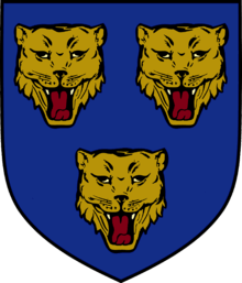
The coat of arms of the former Shrewsbury Borough Council, and now the Town Council, depicts three loggerheads, with the motto Floreat Salopia, a Latin phrase that can be translated to "May Shrewsbury Flourish".[54][55] The coat of arms of the (now abolished) Shrewsbury and Atcham Borough Council was Shrewsbury's shield with the addition of Atcham Bridge running above the loggerheads. Shrewsbury Town F.C. historically used the loggerheads, but from 1986 till 1992 had a Celtic shrew and from 2007 to 2015 had a badge depicting a lion rather than a loggerhead. A new loggerheads badge embedded in a circular shape returned for 2015-16 season. (A loggerhead, in heraldry, means a leopard's head – its naming derived from the carving of such faces on the ends of logs, including battering rams). The flag of Shropshire, and other county crests etc., also uses the three loggerheads.
Demography
| Shrewsbury and Atcham Compared | |||
|---|---|---|---|
| 2001 UK Census | S'bury & Atch. | West Midlands | England |
| Total population | 95,850 | 5,267,308 | 49,138,831 |
| White | 98.5% | 86.2% | 87.0% |
| Asian | 0.4% | 7.3% | 4.6% |
| Black | 0.1% | 2.0% | 2.3% |
| Over 65 years old | 17.2% | 16.0% | 15.9% |
| Christian | 77.9% | 72.6% | 71.7% |
| No Religion | 13.7% | 12.3% | 14.6% |
According to the United Kingdom Census 2001, the population of the town of Shrewsbury was 67,126.[56] The same census put the population of the wider (and now abolished) borough of Shrewsbury and Atcham at 95,850.[56] In 1981 the population of the town was 57,731 and in 1991 the population of the town was 64,219.[57] Shrewsbury is Shropshire's second largest town, after Telford.
The 2001 census also indicates that the population of the town consists of 51.1% females, and 48.9% males, which echoes the trend of Shrewsbury and Atcham borough, and that of Shropshire as a whole.[58] According to the same census, the ethnic composition of the town is largely white, at 98.5% of the total population. The next largest ethnic group is mixed race, at 0.5% of the town's population. 0.4% of the population is Indian, Pakistani or Bangladeshi, and 0.1% of the population is South Asian or British Asian. A further 0.1% is Black, Caribbean or African.[58]
Historical population
The population figures below are for the borough of Shrewsbury and Atcham, which existed only between 1974 and 2009, and covered a much wider area than the town.
| Historical population | |||||||||||||||||||||||||||||||||||||||||||||||||||||||||||||||||||||||||||||||||
|---|---|---|---|---|---|---|---|---|---|---|---|---|---|---|---|---|---|---|---|---|---|---|---|---|---|---|---|---|---|---|---|---|---|---|---|---|---|---|---|---|---|---|---|---|---|---|---|---|---|---|---|---|---|---|---|---|---|---|---|---|---|---|---|---|---|---|---|---|---|---|---|---|---|---|---|---|---|---|---|---|---|
|
|
|
| ||||||||||||||||||||||||||||||||||||||||||||||||||||||||||||||||||||||||||||||
| Source: A Vision of Britain through Time | |||||||||||||||||||||||||||||||||||||||||||||||||||||||||||||||||||||||||||||||||
In 2011, the actual town and parish of Shrewsbury had a population of 71,715.
| Shrewsbury compared | Shrewsbury | Shropshire District |
|---|---|---|
| White British | 93.9% | 95.4% |
| Asian | 1.6% | 1% |
| Black | 0.2% | 0.2% |
In 2011, 6.1% of Shrewsbury's population was non white British compared with 4.6% for the surrounding district.
Economy

Throughout the Medieval period, Shrewsbury was a centre for the wool trade,[60] and used its position on the River Severn to transport goods across England via the canal system. Unlike many other towns in this period, Shrewsbury never became a centre for heavy industry. By the early 1900s, the town became focused on transport services and the general service and professional sector, owing to its position on the A5 road, part of the strategic route to North Wales.[61]
The town is the location of the town and county councils, and a number of retail complexes, both in and out of the town centre, and these provide significant employment. Four in five jobs in the town are in the service industry. Within this sector, the largest employers are the administration and distribution sectors, which includes retail, food and accommodation.[58]

Shrewsbury is home to four shopping centres. The principal centres comprise the Darwin and Pride Hill shopping centres, which house many high street retailers such as Marks & Spencer, H&M, Next, and Boots.[62] Riverside provides further retail accommodation for stores including Wilkinson. A plan to redevelop Riverside and integrate a new development with the Darwin and Pride Hill centres was granted planning permission in April 2012. The project is dubbed "New Riverside".[63][64] The Parade Shopping Centre is a fourth centre exclusively housing independent retailers. There are also two retail warehouse clusters: at Meole Brace Retail Park to the south, and at Sundorne Retail Park to the north. Major supermarkets in the town are the environmentally friendly[65] Tesco Extra at Harlescott, Morrisons on Whitchurch Road, Asda on Old Potts Way, Sainsbury's at Meole Brace, and most recently a Waitrose on Oteley Road.

The visitor economy of Shrewsbury and Atcham was worth about £115 million in 2001, with about 2,500 people employed directly in the visitor industry and 3,400 indirectly. There were about 3.1 million visitors – both day visitors and staying visitors – to the borough in 2001, with 88% being day visitors and 12% being staying visitors; staying visitors accounted for 42% of spending.[66] Shrewsbury's position of being the only sizable town for a large area, especially to the west in Mid-Wales, allows it to attract a large retail base beyond that of its resident population. This is not only evident in the retail sector, but also in the healthcare sector, where the Royal Shrewsbury Hospital has the only A&E department westwards until Aberystwyth, about 75 miles (121 km) away.[67]
Although a less prominent brewing centre than at Burton-on-Trent, beer made in Shrewsbury was celebrated as early as about 1400 when bard Iolo Goch praised the supply of "Crwg Amwythig" dispensed at the Sycharth palace of Owain Glyndwr.[68] In 1900 there were eight breweries in the town, chief among them being Southam's and Trouncer's, which also had their own maltings and owned many local public houses, as well as five other maltsters,[69] but the conventional brewing industry gradually closed after takeovers in the 1960s, and the last maltings, at Ditherington, in 1986. A real ale brewery was established in the town in 1995.[70] The Salopian Brewery is based in the Old Dairy in Mytton Oak Road, and produces cask ale and bottle conditioned beers. It has a production of 80 barrels a week and mainly serves the pubs in and around Shrewsbury.[71]
In terms of social and economic deprivation, according to the Overall Index of Multiple Deprivation of 2004, one Super Output Area (SOA) in the town is in the bottom 15% of all areas nationally. This area is in the ward of Harlescott.[72] A further four SOAs fall into the bottom 30% nationally, these being in the wards of Monkmoor, Sundorne, Battlefield and Heathgates and Meole Brace. The most affluent areas of the town are generally to the south and west, around the grounds of Shrewsbury School, and the Copthorne area.

Architecture
Landmarks

The historic town centre still retains its medieval street pattern and many narrow streets and passages. Some of the passages, especially those that pass through buildings from one street to the next, are called "shuts" (the word deriving from "to shoot through" from one street to another).[73][74] Many specialist shops, traditional pubs and local restaurants can be found in the hidden corners, squares and lanes of Shrewsbury. Many of the street names have also remained unchanged for centuries and there are some more unusual names, such as Butcher Row, Longden Coleham, Dogpole, Mardol, Frankwell, Roushill, Grope Lane, Gullet Passage, Murivance, the Dana, Portobello, Bear Steps, Shoplatch and Bellstone.[75]
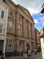
The public library, in the pre-1882 Shrewsbury School building,[76] is on Castle Hill. Above the main entrance are two statues bearing the Greek inscriptions "Philomathes" and "Polymathes". These portray the virtues "Lover of learning" and "Much learning" to convey the lesson that it is good to gain knowledge through a love of learning.

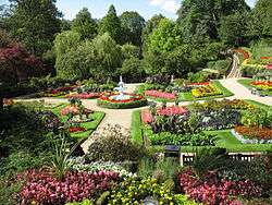
In the centre of the town lies the Quarry. This 29 acre (120,000 m²)[77] riverside park attracts thousands of people throughout the year and is enjoyed as a place of recreation. Shrewsbury has traditionally been known as the "Town of Flowers", a moniker incorporated into many of the signs on entrance to the town via major roads, although this was replaced in 2007 with 'the birthplace of Charles Darwin'.[78]
The British Army's Light Infantry has been associated with Shrewsbury since the 17th century when the first regiments were formed and many more regiments have been raised at Shrewsbury before being deployed all over the world from the American Revolutionary War to the current conflicts in Iraq and Afghanistan. Today, after several major reorganisations, the Light Infantry now forms part of the regiment known simply as the Rifles. Shrewsbury's Copthorne Barracks, spiritual home of the Light Division, still houses the Headquarters of the British Army's 143 (West Midlands) Brigade, while that of the 5th Division disbanded in April 2012 as part of the reorganisation of the Army's Support Command.[79]

Between 1962 and 1992 there was a hardened nuclear bunker, built for No 16 Group Royal Observer Corps Shrewsbury, who provided the field force of the United Kingdom Warning and Monitoring Organisation and would have sounded the four-minute warning alarm in the event of war and warned the population of Shrewsbury in the event of approaching radioactive fallout.[80] The building was manned by up to 120 volunteers who trained on a weekly basis and wore a Royal Air Force style uniform. After the breakup of the communist bloc in 1989, the Royal Observer Corps was disbanded between September 1991 and December 1995. However, the nuclear bunker still stands just inside Holywell Street near the Abbey as a lasting reminder of the Cold War, but is now converted and used as a veterinary practice.
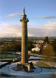
The tourist information centre is situated in the Shrewsbury Museum & Art Gallery in what used to be the old Music Hall theatre in the town square. The three main museums are Shrewsbury Museum & Art Gallery, Shrewsbury Castle (which houses the Shropshire Regimental Museum) and the Coleham Pumping Station.[81] Also, there is the Gateway arts and drama centre and there are also various private galleries and art shops around the town. Another notable feature of the town is Lord Hill's Column, the largest free-standing Doric column in the world.[82]
The Quantum Leap is an abstract sculpture unveiled in the town centre in 2009 to mark the bicentenary on the birth of Shrewsbury biologist Charles Darwin.
Bridges
Shrewsbury, being almost entirely encircled by the River Severn, has nine bridges across the river and many that cross the Rea Brook.

Working downstream from Frankwell Bridge, a modern pedestrian footbridge spans the River Severn between Frankwell and the town centre. Welsh Bridge was built in the 1790s to replace the ancient St George's Bridge.
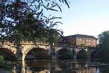
Further along from the Welsh Bridge is the Porthill Bridge, a pedestrian suspension bridge running between the Quarry and Porthill, built in 1922. The next bridge along the river is Kingsland Bridge, a privately owned toll bridge, and the subsequent bridge is the Greyfriars Bridge, a pedestrian bridge between Coleham and the town centre. Following the Greyfriars Bridge is the English Bridge, historically called Stone Bridge, which was rebuilt in the 1930s. Beyond it is the railway station, which is partly built over the river. After the station is Castle Walk Footbridge, another modern pedestrian footbridge.[83] The last bridge to cross the river within the Shrewsbury bypass area is called Telford Way, which has separate lanes for vehicles (A5112), bicycles and pedestrians. A. E. Housman wrote of the area this verse, which mentions the bridges of the town:[84]
| “ | High the vanes of Shrewsbury gleam |
” |
Religious sites

There are many churches in Shrewsbury, including Shrewsbury Abbey, founded by Roger de Montgomery in 1083.[85] Shrewsbury Greek Orthodox Church, a former Anglican church building, is off Sutton Road to the south.[86] Shrewsbury is home to the Roman Catholic Shrewsbury Cathedral, by the Town Walls,[87] as well as two other parishes in Harlescott and Monkmoor, within the Roman Catholic Diocese of Shrewsbury. One of the houses in Fish Street, facing St Alkmund's Church, was the site of John Wesley's first preaching in Shrewsbury; a wall plaque records the date as 16 March 1761. According to legend, the spire of St Alkmund's Church was damaged by the Devil in 1553, and climbed four times by a drunken steeplejack in 1621.[88]
There are several Anglican churches in Shrewsbury.[89] Methodists,[90] Baptists[91] and the United Reformed Church are also represented, alongside newer church groups including Elim Pentecostal[92] and Newfrontiers.[93][94] Shrewsbury Evangelical Church meets in the former Anglican parish church of St Julian at the Wyle Cop end of Fish Street.[95] Shrewsbury's first non-Christian place of worship, a Muslim centre, was approved in 2013.[96]
Many community projects in Shrewsbury are based in, or have been started by local churches, including the Isaiah 58 project, which is the primary work amongst homeless people in the town, whilst 'Churches Together in Shrewsbury' works to help homeless people through the Ark project.[97][98] Basics Bank, based at the Barnabas Centre, provides debt relief for local people.[99]
Culture
Museums and entertainment
Shrewsbury is home to one of the largest horticultural events in the UK, it is also the 'Longest running flower show in the world' – the annual Shrewsbury Flower Show.[100] A two-day event, the Flower Show takes place in mid-August, has been running for more than 125 years, and attracts around 100,000 visitors each year. Set in the Quarry park, there are a multitude of events, exhibitions and displays, with a fireworks display at the end of each day. The town is well known for its flower displays, and has won numerous awards in recent years.[101]

Theatre Severn[102] is the town's main performing arts complex. It is situated in Frankwell next to the Welsh Bridge and alongside its namesake, the River Severn. The theatre includes two performance spaces, the 635 seat Main Auditorium and a smaller studio space, the Walker Theatre which can accommodate 250 seating or 500 standing. In November 2015 the theatre celebrated the sale of its 1 millionth ticket since its opening in 2009. The venue also includes a full sized dance studio, function rooms and restaurant.[103] The new complex replaced the old theatre, the Music Hall, which itself has been refurbished and expanded in preparation for its current use as home to Shrewsbury Museum and Art Gallery[104] (opened 2014). Further museums in the town include the acclaimed Shropshire Regimental Museum, based at Shrewsbury Castle, and the restored 19th century steam-powered Coleham Pumping Station, which opens for tours on specific days each year. Nearby National Trust properties include Attingham Park, former home of the Noel-Hill family, Barons of Berwick, and the last remaining Town Walls Tower which dates from the 14th century.[105]
Shrewsbury is also home to one of the region's main agricultural shows – the Shropshire County Show (formerly the West Mid Show). This is held every year, usually in May, at the Shropshire Agricultural Showground on the outskirts of town at Coton Hill.[106] The town is host to the Shrewsbury International Music Festival, when musical groups from all over the world come to perform for about a week for local residents, and give a final concert in the abbey. The festival is organised by WorldStage Tours.[107] 2006 saw the first Shrewsbury Folk Festival, after the event moved to the town from nearby Bridgnorth. Held annually over the August bank holiday, the event is very popular, with people travelling from across the UK to attend. In 2006 much of the event was held in the Quarry, with other related festivities happening around the town. For 2007 the event moved to the West Midlands Showground on the other side of the river.[108] A new annual arts festival – the Shrewsbury Summer Season – was established in 2004 and runs each year from June to August with an extensive programme of music, visual arts, theatre and spectacle.[109]
There are some very old public houses, which have been continuously open, such as the Golden Cross in Princess Street, the Dun Cow in Abbey Foregate, and the King's Head in Mardol. The Golden Cross is reputed to be the oldest licensed public house in Shrewsbury and records show that it was used as an inn as far back as 1428. Its original name was the Sextry, because it was originally the sacristy of Old St Chad's Church.[110]
In the arts

Famous literary figures who have visited the town include (in the 17th century) Daniel Defoe, Celia Fiennes, the Shrewsbury School-educated Arthur Mainwaring and Ambrose Phillips and playwright George Farquhar whose 1706 play 'The Recruiting Officer' was set in the town.[111]
Later, in the 18th and 19th centuries, the likes of John Wesley, Thomas de Quincey and Benjamin Disraeli the latter of which was MP for Shrewsbury 1841–47, would visit the town. Charles Dickens once also visited to present a series of lectures at the Music Hall, staying at the Lion Hotel. However, in this period the town's most prolific literary figure and famous son was born – Charles Darwin. Darwin was educated at Shrewsbury School and later, with the development of his 1859 work On the Origin of Species became the preeminent naturalist of the 19th century. Although Darwin's work was both revolutionary and highly controversial at the time, his teachings and beliefs have become ever more globalised and he is today widely recognised as the father of the modern theory of evolution.
In his 1910 novel Howards End, E. M. Forster makes a brief reference to "astonishing Shrewsbury", an impression he received after having visited the town in the early 20th century. In the same century Shrewsbury became famous for its poets. The Great War poet Wilfred Owen was a resident, whilst his fellow poet Mary Webb much loved the town and referred to it many a time in her works under the guise of Silverton. Owen is the subject of the 1993 sculpture Symmetry, which was unveiled in the grounds of Shrewsbury Abbey, whilst Webb was finally laid to rest in one of the town's cemeteries.[111]
The town appears in the Brother Cadfael novels by Ellis Peters (pen name of Edith Pargeter). The novels take Shrewsbury Abbey for their setting, with Shrewsbury and other places in Shropshire portrayed regularly, and have made Medieval Shrewsbury familiar to a wide worldwide readership.[112]
The local author, Carol Ewels has written two children's books, including Jack the Cat, which are set in the town. Also, the children's author Pauline Fisk wrote about a town called Pengwern, which is based entirely on Shrewsbury, in books including Midnight Blue and Sabrina Fludde. Frank Cottrell Boyce, another children's author, writes briefly about Shrewsbury in his book Millions. Shrewsbury Library also hosts the West Midlands Literary Heritage website, developed to provide information about West Midland people and places, including those featured in the library's own West Midland Creative Literature Collection.
In film Shrewsbury was used as the setting for the popular 1984 film, A Christmas Carol,[113] which filmed many of its interior and exterior shots in and around the town. The gravestone prop of Ebenezer Scrooge (played by George C. Scott) that was used in the movie is still present in the graveyard of St Chad's Church.
Media
Two newspapers are published for Shrewsbury – the local edition of the county's Shropshire Star and the more traditional Shrewsbury Chronicle, which is one of the oldest weekly newspapers in the country, having produced its first edition in 1772.[114][115] There are presently three radio stations that specifically serve either the Shrewsbury area or encompass it as part of a Shropshire-wide broadcast. They include: Free Radio Shropshire & Black Country;,[116] BBC Radio Shropshire, which is based in Shrewsbury;[117] and, as of September 2006, The Severn, which broadcasts from the Shropshire Star building in Telford.[118]
In 2009 a brand new online independent media company launched covering Shrewsbury and Shropshire. shropshirelive.com,[119] is based in Shrewsbury with local residents encouraged to get involved with the web site by becoming citizen journalists and contributors.
Food
.JPG)
Shrewsbury is well known in culinary circles for being the namesake of a classic English dessert. Shrewsbury cakes (or biscuits) are typically crisp and brittle creations that may incorporate fruit. They can be small in size for serving several at a time, or large for serving as a dessert in their own right. Traditionally Shrewsbury cakes have a distinct hint of lemon.
The playwright William Congreve mentioned Shrewsbury cakes in his play The Way of the World in 1700 as a simile [120] (Witwoud – "Why, brother Wilfull of Salop, you may be as short as a Shrewsbury cake, if you please. But I tell you 'tis not modish to know relations in town"). The recipe is also included in several early cookbooks including The Compleat Cook of 1658.[121] A final reference to the cakes can be seen to this day as the subject of a plaque affixed to a building close to Shrewsbury's town library at the top of Pride Hill. The aforementioned plaque marks the spot where the Shrewsbury Cake's recipe is said to have been pioneered in 1760 by Mr Pailin; a further quote, drawn from Richard Harris Barham's Ingoldby Legends, reads:
| “ |
Oh! Pailin. Prince of Cake Compounders |
” |
Shrewsbury is also the origin of the most popular Simnel cake recipe. Different towns had their own recipes and shapes of the Simnel cake. Bury, Devizes and Shrewsbury produced large numbers to their own recipes, but it is the Shrewsbury version that became most well known. Shrewsbury also had a large cheese market in Victorian times.
Education

Shrewsbury is home to Shrewsbury School, a public school, on a large site ("Kingsland") just south of the town centre overlooking the loop of the Severn. The school was once in the town centre, in the buildings that are now the main county library on Castle Street.[122] Opposite it on the other side of the river is Shrewsbury High School, an independent girls' day school.
The long established Prestfelde School is an independent preparatory school, on London Road, close to the Lord Hill column. As part of the Woodard Schools group, it is affiliated to the largest group of Church of England schools in the country. Whilst originally a school for boys only it diversified and, in the late 1990s, started also accepting girls between the ages of three and thirteen. The school is set in 30 acres (12 ha) of grounds on the outskirts of the town.[123] The town's other long-established boys' preparatory school, Kingsland Grange (on Old Roman Road in Kingsland), in 2007 merged with the junior department of Shrewsbury Girls' High School, sharing the two sites with some classes remaining all-boys or all-girls, but others switching to a co-ed format.[124]

Adcote School is an independent day and boarding school for girls, 5 miles (8.0 km) northwest of Shrewsbury. The school was founded in 1907 and is set in a Grade I listed country house built in 1879 for Rebecca Darby – a great niece of Abraham Darby and a member of the iron-master family who built Ironbridge.
However, the majority of the town's pupils attend one of the seven comprehensive schools. The Priory School, formerly a grammar school for girls;[125] Meole Brace School currently carries the status of Science College; The Grange School the status of Arts College; Sundorne School the status of Sports College and Belvidere School has the status of Technology College.
In 2016, The Grange and Sundorne officially merged to form Shrewsbury Academy. The school has two campuses however it is planned in the next few years for all pupils to move to Sundorne (formally cordon creasent). In the future a new building will be constructed in Shrewsbury to house Shrewsbury academy.
The Wakeman School, which was geographically the closest school to the town centre 'loop', next to the English Bridge, was previously called Shrewsbury Technical School, and was attended by the notable First World War poet Wilfred Owen. It closed as part of reorganisation in July 2013.[126] Additionally, two other establishments outside town serve town students - The Corbet School to the north at Baschurch; and Mary Webb School, in the village of Pontesbury to the south-west.
Post-16 education is handled by Shrewsbury Sixth Form College, previously the Priory School for Boys[127] recently ranked 17th in the top 20 of sixth form colleges nationally by the Sunday Times newspaper and Shrewsbury College of Arts and Technology, which handles primarily vocational courses.
University Centre Shrewsbury has been offering postgraduate courses since autumn 2014 and undergraduate students are being welcomed to the institution from autumn 2015.
Established by the University of Chester and Shropshire Council, the University Centre is focused on high-quality teaching and research, fostering entrepreneurship, contributing to the community and, ultimately, making a global impact.[128]
Transport

Shrewsbury is the county's public transport hub and has road and rail links to the rest of the county and country.
Five railway lines connect the town to most corners of Shropshire and the region, and the town is known as the "Gateway to Wales". Shrewsbury railway station is served by Arriva Trains Wales and London Midland with trains running north to Chester, Manchester, Crewe and Wrexham, south to Hereford and Cardiff, west to Aberystwyth, and east to Birmingham via Telford, Shifnal, and Wolverhampton.[129] Heart of Wales Line trains also operate to Swansea. On 28 April 2008, open access operator Wrexham & Shropshire commenced services to London, restoring the county's direct rail link to the capital; previously, Shropshire had been one of only two mainland English counties without a dedicated service to the capital, the other being Rutland.[130] However, the service ceased on 28 January 2011. Virgin Trains announced in September 2014 that a new London service comprising two trains in each direction daily would be introduced in December of that year.[131]
The main railway station building includes a clock tower, imitation Tudor chimneys and carved heads in the frames of every window. There is a small British Transport Police station within the building.
Bus services in the town are operated by Arriva Midlands and serve most parts of the town, congregating at the town's bus station adjacent to the Darwin Shopping Centre and a short stroll from the railway station. Arriva also operate county services both independent of and on behalf of Shropshire County Council. There are other bus companies operating around the Shrewsbury area, including Boulton's of Shropshire, Minsterley Motors, Bryn Melyn and Tanat Valley Coaches with the last operating services crossing from over the Welsh border from nearby towns including Llanfyllin, Montgomery, Newtown and Welshpool.
Shrewsbury has a Park and Ride bus scheme in operation and three car parks on the edge of town are used by many who want to travel into the town centre. The three car parks are at Harlescott (to the north, colour-coded blue), Oxon (to the west, colour-coded pink) and Meole Brace (to the south, colour-coded green). It is proposed that a fourth one be built to the east of the town, at either Emstrey or Preston.[132]

Shrewsbury has been an important centre for road traffic. In 1815, Thomas Telford designed a new coaching route from London to Holyhead in order to improve communications with Ireland. He routed the new road via Shrewsbury, which opened in 1830. The road is now the A5.[133] The road connects the town northwest to Oswestry, and east towards Telford, where it joins the M54. The A5 once ran through the town centre, until a bypass was built in the 1930s. Subsequently, in 1992, a 17-mile (27 km) dual carriageway was completed at a cost of 79 million pounds to the south of the town, and was made to form part of the A5 route. This dual carriageway was built further out of the town to act as a substantial link to Telford, as well as a bypass for the town.[134]
The A49 also goes to Shrewsbury, joining the A5 at the south of the town, coming from Ludlow and Leominster. At this point the road merges with the A5 for 3 miles (4.8 km), before separating again to the east of the town. From there it runs north, passing Sundorne, then Battlefield, before heading out towards Whitchurch. At Battlefield, the A53 route begins and heads northeast towards Shawbury and Market Drayton then onwards towards Newcastle-under-Lyme and Stoke-on-Trent.
The A458 (Welshpool-Bridgnorth) runs through the town centre, entering in the west and leaving to the southeast. The A528 begins in the town centre and heads north, heading for Ellesmere. The A488 begins just west of the town centre in Frankwell and heads out to Bishop's Castle, Clun and Knighton crossing the border in the southwest of Shropshire.
Major roads within the town include the A5112, A5191 and A5064. The A5191 goes north-south via the town centre, while the A5112 runs north-south to the east of the town centre. The A5064 is a short, one mile (1.6 km) stretch of road to the southeast of the town centre, called "London Road". Additionally, the A5124, the most recent bypass, was completed in 1998, and runs across the northern edge of the town at Battlefield (connecting the A49/A53 to the A528), though it did exist before as Harlescott Lane (which has since become unclassified).
Cycling
Shrewsbury has a comprehensive network of on-road and traffic-free cycle routes.[135] In 2008 Shrewsbury was awarded Cycling Town status by Cycling England.[136] As a result, Shrewsbury benefited from £1.8 million of grant funding from the Department for Transport between 2008 and 2011. The funding was used to make improvements to the cycle network in Shrewsbury, and to provide cycle training, information and advice to people to help encourage them to cycle to school and work.[137]
Sport
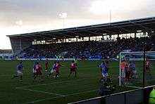
Shrewsbury is home to a professional football club, Shrewsbury Town. The team currently competes in the third tier of English football, Football League One and since 2007 has played their home games at New Meadow – from 1910 to 2007 the club played at the Gay Meadow stadium. Shrewsbury Town's achievements include winning the Welsh Cup six times, a record for an English club, a 10-year run in the old Second Division now known as The Championship from 1979 until 1989, a Third Division Championship in 1979, a Division 3 Championship and victory in the Conference National Playoff Final 2004.
There is also a local rugby club, Shrewsbury Rugby Club.[138] The River Severn in the town is used for rowing by both Pengwern Boat Club[139] and the Shrewsbury School Boat Club.[140] Shrewsbury Sports Village is a sports centre in the Sundorne district of the town, aimed at providing a wide range of sports facilities for townspeople.[141] There are also a number of motorsports and golf facilities (including Meole Brace Municipal Golf Course) in the area. The local motorsports heritage includes the Loton Park Hillclimb and Hawkstone Park Motocross Circuit near Shrewsbury. Shrewsbury Motocross Club has staged motocross events in the area for over 30 years.[142]
Shrewsbury Cricket Club is currently one of the most successful club cricket sides in the country. They have won the EBC National Club Championship twice in 1983 and recently in 2011. England International player James Taylor currently plays for Shrewsbury.
A free weekly parkrun takes place in the centre of Shrewsbury. The event is attended by over 250 runners every week and is 'twinned' with Darwin parkrun in Northern Territory, Australia due to the city of Darwin being named after Charles Darwin. Shrewsbury has also seen activity in the physical discipline, Parkour.[143]
Notable Salopians

There have been a number of notable Salopians, and people otherwise associated with the town of Shrewsbury, including Charles Darwin, a biologist and evolutionary theorist, one of the most important thinkers of the 19th century,[144] who was born in Shrewsbury on 12 February 1809 at the Mount House,[145] and was educated in the town at Shrewsbury School.
People with political associations also have connections with the town. Leo Blair, the father of former Prime Minister Tony Blair, was a resident of the town.[146] Former residents have included Michael Heseltine, a Conservative politician who was educated at Shrewsbury School,[147] and Sir William Pulteney, 5th Baronet, who was once Britain's richest man, and was MP for Shrewsbury.[148] He lived in apartments at Shrewsbury Castle. Robert Clive was MP for Shrewsbury, and also the mayor.[149]
Ian Hunter (or Ian Patterson), the lead singer of the 1970s pop group Mott the Hoople, was a resident of 23a Swan Hill in the town centre, and wrote a song of the same name.[150] Also a resident of the town was John Peel, a DJ and radio presenter, who was educated at Shrewsbury School.[151] Another DJ from the town is Lange, a producer of dance music, who was born in Shrewsbury.[152] The 1980s pop group T'Pau was formed in the town and the band's vocalist Carol Decker was born and educated in the town, along with other members of the band.[153] Notable music historian Charles Burney was born and educated in the town.
Shrewsbury has also been home to contributors to literature. In the early years of the 18th century, the Irish dramatist George Farquhar resided in the town while acting as a recruiting officer for the Army. He drew on this experience in writing the comedy The Recruiting Officer. Prior to the First World War, the poet Wilfred Owen lived in the town.[154] The romantic novelist Mary Webb is buried there.[155] Michael Palin, the writer, actor and comedian attended Shrewsbury School.[156] Other actors with associations with the town include Nick Hancock, presenter of They Think It's All Over, who, like Palin, was educated at Shrewsbury School.[157] Nick Conway is another actor connected to the town, and was born in it in 1962.[158] Actor Jason Bateman's mother was born in Shrewsbury.[159] Comedian George Robey lived in the town, near Lord Hill's Column, before and during the Second World War.[160]

Sporting Salopians include footballers Danny Guthrie of Newcastle United[161] and Shrewsbury Town youth academy graduates England goalkeeper Joe Hart[162] and Wales midfielder David Edwards, both of whom are currently playing in the Premier League. Sunderland and Scotland striker Steven Fletcher was also born in the town, where his serviceman father was stationed. Four FA Cup Final winning players who took part in the first decade of the Cup's history were born in or lived in Shrewsbury: John Hawley Edwards, Henry Wace and John Wylie, of the Wanderers and Clopton Lloyd-Jones of Clapham Rovers. Sandy Lyle, a professional golfer, was also born in the town.[163] Neville Cardus spent some of his formative years as assistant cricket coach at Shrewsbury School.[164]
Other notable people of the town include Robert Cadman, a performer and steeplejack, who is buried in the town, at St Mary's Church.[165] Simon Gosling, a visual effects designer was born in the town, and was resident there until 1994.[166] John Gwynn, an 18th-century architect, who designed the English Bridge and the bridge at Atcham was born in the town.[167] Percy Thrower, the gardener and broadcaster lived in Shrewsbury, where he set up the garden centre near Meole Brace and just down the road from the football club.[168] It is currently the home of renowned singer Steve Winwood, with his family.
Flight Lieutenant Eric Lock DSO, DFC and Bar was born in nearby Bayston Hill and was educated at Prestfelde public school on London Road. Lock became internationally recognised as a high scoring fighter ace of the Royal Air Force in the Second World War with 26 victories before his death in combat at the age of 21. He was the RAF's most successful British-born pilot in the Battle of Britain, shooting down 16.5 German aircraft in a period of just a few weeks.[169][170]
One Victoria Cross recipient is known to have lived in Shrewsbury; Arthur Herbert Procter, who was decorated in 1916 during World War I and retired from his later full-time clergy ministry in 1964 to briefly live at Mytton Oak Road, Copthorne.[171]
The forerunner of Private Eye was a school magazine edited by Richard Ingrams, Willie Rushton, Christopher Booker and Paul Foot at Shrewsbury School in the mid-1950s.[172]
Comic book artist Charlie Adlard was born in Shrewsbury and is most known for illustrating The Walking Dead. Actor Adam Rayner was born in Shrewsbury and grew up in the United States. Comedian, Impressionist and one half of The Mimic Men, featuring on Britain's Got Talentwith Alfie Joey, Cal Halbert was also born and lived in Shrewsbury before relocating to Newcastle-Upon-Tyne.
Twin Town
Shrewsbury is twinned with Zutphen, Netherlands, a move inspired by the fact Sir Philip Sidney, an alumnus of Shrewsbury School, was fatally wounded there in 1586. At the end of the Second World War Shrewsbury's then Mayor, Harry Steward, who was made in 1946 an honorary citizen of Zutphen in return, launched an appeal for second-hand tools, clothes, bedding and other materials towards the town's post-war reconstruction after Nazi German occupation and war damage.[173]
A potential twinning with Shrewsbury by Bayreuth, Germany, was under discussion in 2009.[174]
See also
References
- 1 2 3 National Statistics – population density and area of the parish of Shrewsbury in 2011
- ↑ "'Shroosbury' v 'Shrowsbury'". Shropshire Star. Shrewsbury: MNA Media. 6 February 2008. p. 1. Archived from the original on 15 March 2015. Retrieved 6 March 2013.
- ↑ Room, Adrian (2006). Placenames of the World: Origins And Meanings of the Names for 6,600 Countries, Cities, Territories, Natural Features And Historic Sites. Stamford: McFarland. p. 345. ISBN 0786422483.
- ↑ "Destination Guide for Shrewsbury". Enjoy England. Retrieved 25 September 2007.
- ↑ "Shrewsbury Castle". VisitShrewsbury.co.uk. Retrieved 30 July 2014.
- ↑ "Town celebrates top floral awards". BBC News. 23 September 2007. Retrieved 23 September 2007.
- ↑ "Town wins Floral prize". Shrewsbury Chronicle. Retrieved 23 September 2007.
- ↑ "Britain in Bloom Winner 2006 (archived version)". Royal Horticultural Society. Archived from the original on 2007-06-25. Retrieved 24 February 2008.
- ↑ Simon Jenkins, 2008, Wales, Allen Lane, London, p. 245
- 1 2 3 4 "Imperial Gazetteer entry for Shrewsbury". Visions of Britain. Retrieved 4 March 2008.
- ↑ "Shrewsbury". JRANK Encyclopedia. Retrieved 23 February 2008.
- ↑ "Shrewsbury". MSN Encarta. Retrieved 24 February 2008.
- ↑ "Shrewsbury Guide". Websitehome.co.uk. Retrieved 23 February 2008.
- ↑ "The Wroxeter Hinterland Project". University of Birmingham. Retrieved 23 February 2008.
- 1 2 3 Lambert, Tim. "Saxon and Medieval Shrewsbury". A Short History of Shrewsbury, Shropshire, England. A World History Encyclopaedia.
- ↑ "The Economic Journal". JSTOR.org. Retrieved 23 February 2008.
- ↑ History of Shrewsbury Drapers, Shrewsbury Drapers, retrieved 2016-04-02
- ↑ "Battle of Shrewsbury – Henry VI at Shrewsbury". About.com. Retrieved 23 February 2008.
- 1 2 "Establishment of Shrewsbury Town Council". Shrewsbury and Atcham Borough Council. Retrieved 4 April 2008.
- ↑ Carlton 1994, p. 262.
- ↑ "Shrewsbury, the house at the Castle Gates and the hanged Irish mercenaries". Gwendda. 29 January 2015.
- ↑ "Kings Shropshire Light Infantry". Durham Light Infantry Association, South Shields. 7 January 2013.
- ↑ "History of Charles Darwin" (PDF). Ondix.com. Retrieved 23 February 2008.
- ↑ W. G. Rimmer, 'Castle Foregate Flax Mill, Shrewsbury' Transactions of Shropshire Archaeological Society LVI (1957–60), 49ff.
- ↑ "Father of the Skyscraper". English Heritage. Retrieved 23 February 2008.
- ↑ "Thomas Telford in Shropshire". BBC Shropshire. Retrieved 4 March 2008.
- ↑ Simcox, Kenneth (1983). A Town at War, Shrewsbury 1939–45. Shropshire Libraries. p. 14. ISBN 0-903802-25-2.
- ↑ Rowley, Trevor. The English Landscape in the Twentieth Century. Retrieved 13 April 2008.
- ↑ "Shrewsbury flood alleviation scheme". Environment Agency. Archived from the original on 2007-01-10. Retrieved 24 February 2008.
- ↑ "Flood watch continues on Severn". BBC Shropshire News. 10 December 2007. Retrieved 24 February 2008.
- ↑ "Five new cities creates row". BBC News. 14 March 2002. Retrieved 23 February 2008.
- ↑ "Advantage WM". Retrieved 18 September 2007.
- ↑ "Travel – A day on the Shrewsbury-Birmingham line". BBC Shropshire. Retrieved 13 April 2008.
- ↑ "Jail most overcrowded in country". BBC News. 27 July 2005. Retrieved 16 January 2008.
- ↑ Shropshire Star Sold: Shrewsbury's Dana prison to become homes and offices (20 November 2014)
- ↑ "Haughmond Hill". Shropshire Geology. Retrieved 2 January 2008.
- ↑ "Shropshire's Geological Trail". Shropshire Rocks!. Archived from the original on 19 November 2008. Retrieved 2 January 2008.
- ↑ "Bayston Hill Parish Council". Shrop.net. Archived from the original on 27 July 2007. Retrieved 16 March 2008.
- ↑ "Expansion of Retail parks". Shrewsbury & Atcham council. Retrieved 16 March 2008.
- ↑ "Shropshire". MSN Encarta. Retrieved 24 February 2008.
- ↑ "1971-00 average warmest day". Retrieved 3 March 2011.
- ↑ "1971-00 >25c days average". Retrieved 3 March 2011.
- ↑ "1990 Maximum". Retrieved 3 March 2011.
- ↑ "1971-00 average coldest day". Retrieved 3 March 2011.
- ↑ "1981 December". Retrieved 3 March 2011.
- ↑ "Climate Normals 1971–2000". MetOffice. Retrieved 3 Mar 2011.
- ↑ "Climate Normals 1971–2000". KNMI. Retrieved 23 Feb 2011.
- ↑ The Column – Shropshire Council
- ↑ "Shropshire County Council Home Page". Shropshire County Council. Retrieved 23 February 2008.
- ↑ "Benjamin Disraeli (1804–1881)". VictorianWeb.org. Retrieved 23 February 2008.
- ↑ "Culture and Arts – Zutphen on the Ijsel". BBC Shropshire. Retrieved 18 September 2007.
- ↑ "British Light Infantry Regiments". LightInfantry.org.uk. Retrieved 23 February 2008.
- ↑ Shrewsbury Town Council
- ↑ "Origins of the name of Shrewsbury". Shrewsbury and Atcham Borough Council. Retrieved 17 January 2008.
- ↑ "Shrewsbury and Atcham Borough Council". civicheraldry.co.uk. Retrieved 5 April 2008.
- 1 2 "Census – 2001 – Population & Age Structure". Shropshire County Council. Archived from the original on 30 June 2006. Retrieved 2 January 2008.
- ↑ "Shrewsbury". World Gazetteer. Retrieved 16 January 2008.
- 1 2 3 "Shrewsbury Town" (PDF). Safety Partnership. Archived from the original (PDF) on 2008-12-17. Retrieved 17 January 2008.
- ↑ http://www.neighbourhood.statistics.gov.uk/dissemination/LeadPage.do?pageId=1001&tc=1461003324078&a=7&b=6275233&c=shropshire&d=13&e=62&f=32826&g=6460319&i=1001x1003x1032x1004x1005&l=2477&o=362&m=0&r=1&s=1461003324078&enc=1
- ↑ "The Shrewsbury Drapers Guild". shrewsburydrapers.org.uk. Retrieved 4 April 2008.
- ↑ "Shrewsbury, Shropshire Industry Statistics". A Vision of Britain. Retrieved 9 March 2008.
- ↑ "Darwin & Pride Hill Shopping Centres, Shrewsbury". EFM Facilities, Ltd. Retrieved 23 March 2008.
- ↑ "£150m Shrewsbury mega mall approved", Construction Enquirer, 19 April 2012
- ↑ "Property Week, Shearer shapes Shrewsbury". Retrieved 1 February 2011.
- ↑ "Tesco Corporate Responsibility Review 2007". Tescocorporate.com. Retrieved 16 April 2008.
- ↑ "A Visitor Economy Strategy and Action Plan for Shrewsbury & Atcham". Shrewsbury & Atcham Borough Council. Retrieved 21 March 2008.
- ↑ "Hospital's cash plans are delayed". BBC News. 10 July 2006. Retrieved 23 February 2008.
- ↑ Pidgeon, Henry (1851). Memorials of Shrewsbury. p. 261.
- ↑ Kelly's Directory of Shropshire. Kelly's. 1900. pp. 333, 391.
- ↑ "Salopian Brewing Company Ltd". www.quaffale.org.uk. Retrieved 26 May 2010.
- ↑ ":: Welcome to Salopian Breweries". Salopian Brewery. Retrieved 26 May 2010.
- ↑ "Index of multiple deprivation – overall results". Shropshire County Council. Retrieved 17 January 2008.
- ↑ "Shuts of Shrewsbury". Proud Salopian, ShrewsburyForum.co.uk. Retrieved 23 February 2008.
- ↑ Scott-Davies, Allan; Sears, R.S., Shuts and Passages of Shrewsbury, Shropshire Books, June 1986. ISBN 978-0-903802-34-5
- ↑ "Shropshire Information". FatBadgers.co.uk. Retrieved 23 February 2008.
- ↑ "Shrewsbury School history". shrewsbury.org.uk. Retrieved 11 May 2009.
- ↑ "Welcome to the Shrewsbury Flower Show". Shrewsbury Flower Show. Retrieved 2 January 2008.
- ↑ "Shrewsbury Tourist Information & Visitor's Guide". ShrewsburyGuide.info. Retrieved 23 February 2008.
- ↑ "The Kings Shropshire Light Infantry (53rd and 85th foot)". Army.mod.uk. Archived from the original on 28 July 2006. Retrieved 4 March 2008.
- ↑ "UKWMO Group Controls". Subbrit.org.uk. Retrieved 17 March 2008.
- ↑ "Shrewsbury Museums". Shrewsbury Museum Service. Retrieved 18 September 2007.
- ↑ "Photo Gallery". Shrewsbury and Atcham Borough Council. Retrieved 2 January 2008.
- ↑ "A Short History of Shrewsbury". localhistories.org. Retrieved 3 February 2008.
- ↑ "Complete Housman". greenend.org.uk/~martinh. Retrieved 17 March 2008.
- ↑ "History of Shrewsbury Abbey". ShrewsburyAbbey.com. Retrieved 17 March 2008.
- ↑ "Shrewsbury Orthodox Church". ShrewsburyOrthodox.com. Retrieved 17 March 2008.
- ↑ "Shrewsbury Cathedral Home Page". ShrewsburyCathedral.org. Retrieved 17 March 2008.
- ↑ Ash, Russell (1973). Folklore, Myths and Legends of Britain. Reader's Digest Association Limited. p. 328. ISBN 9780340165973.
- ↑ Archbishops' Council. "Shrewsbury". A Church Near You. Church of England. Retrieved 17 March 2008.
- ↑ "Belle Vue Methodist Church, Shrewsbury UK". bvmc.freeuk.com. Retrieved 17 March 2008.
- ↑ "Claremont Baptist Church". Claremont-Baptist-Church.co.uk. Retrieved 17 March 2008.
- ↑ "Rivers Way – An Elim Church". RiversWayelim.org. Retrieved 17 March 2008.
- ↑ "Barnabas Community Church, Shrewsbury". BarnabasCommunityChurch.com. Retrieved 17 March 2008.
- ↑ "North Shrewsbury Community Church". NorthShrewsbury.org.uk. Retrieved 17 March 2008.
- ↑ "Shrewsbury Evangelical Church". shrewsburyevangelicalchurch.org. Retrieved 27 December 2008.
- ↑ "Shrewsbury Muslim prayer centre plans approved". Shropshire Star. MNA Media. 21 June 2013.
- ↑ "Churches Together in Shrewsbury – The Shrewsbury Ark". ShrewsburyChurches.org. Retrieved 17 March 2008.
- ↑ "Isaiah 58 Project". shrop.net. Archived from the original on 29 February 2008. Retrieved 17 March 2008.
- ↑ "Debt Relief – Barnabas Community Church Shrewsbury". BarnabasCommunityChurch.com. Retrieved 17 March 2008.
- ↑ "Shrewsbury Flower Show website". Retrieved 18 September 2007.
- ↑ "Town celebrates top floral awards". BBC News. 23 September 2007. Retrieved 23 September 2007.
- ↑ "New Enternainment Venue – Theatre Severn". Shrewsbury.gov.uk. Retrieved 18 September 2007.
- ↑ "New Entertainment Venue". The Music Hall website. Archived from the original on 10 August 2007. Retrieved 18 September 2007.
- ↑ Exhibit in Former C&A, Pride Hill Shopping Centre, Shrewsbury. Published by SABC council. Viewed 20 February 2008
- ↑ "Attingham Park Estate: Town Walls". National Trust.
- ↑ "West Mid Show". WestMidShow.co.uk. Retrieved 23 February 2008.
- ↑ "Festivals – Shrewsbury". eayo.org. Retrieved 23 February 2008.
- ↑ "Shrewsbury Folk Festival website". shrewsburyfolkfestival.co.uk. Retrieved 18 September 2007.
- ↑ "Shrewsbury Summer Season". ShrewsburySummer.co.uk. Retrieved 18 September 2007.
- ↑ "Shrewsbury's oldest pub". GoldenCrossHotel.co.uk. Retrieved 23 February 2008.
- 1 2 "Shrewsbury". Literary Heritage West Midlands. Shropshire Council. 16 September 2008.
- ↑ "Brother Cadfael". user.chollian.net/~beringar. Archived from the original on 15 December 2007. Retrieved 23 February 2008.
- ↑ "A Christmas Carol". The Internet Movie Database. Retrieved 16 January 2008.
- ↑ "Shrewsbury Chronicle". Retrieved 23 February 2008.
- ↑ "Shropshire Star". MNA Media. Retrieved 23 February 2008.
- ↑ "Free Radio Shropshire & Black Country". Retrieved 27 March 2012.
- ↑ "BBC Radio Shropshire". Retrieved 23 February 2008.
- ↑ "106.5 & 107.1 The Severn". Retrieved 23 February 2008.
- ↑ "shropshirelive.com".
- ↑ Congreve, William (1700). "The Way of the World". The Way of the World. Full Books. Retrieved 21 June 2009.
- ↑ "Shrewsbury Cake Recipes". The Olde Cookery Book. Retrieved 21 June 2009.
- ↑ "History of Shrewsbury School". Shrewsbury School. Retrieved 2 March 2008.
- ↑ "Prestfelde Preparatory School Home Page". Prestfelde Preparatory School. Retrieved 2 March 2008.
- ↑ "Shrewsbury High Prep at Kingsland Grange". Independent Schools Directory. Retrieved 21 February 2009.
- ↑ "League tables: Secondary Schools in Shropshire". BBC.co.uk. Retrieved 26 February 2008.
- ↑ Shropshire Star report, 'Memories sought', 13 October 2012.
- ↑
- ↑ http://www.ucshrewsbury.ac.uk University Cenntre Shrewsbury website. Retrieved 22 May 2015.
- ↑ "Shrewsbury Railway Station". NationalRail. Retrieved 23 February 2008.
- ↑ "Wrexham & Shropshire railway services". wrexhamandshropshire.co.uk. Archived from the original on 10 February 2011. Retrieved 23 February 2008.
- ↑ http://www.virgintrains.co.uk/about/media-room/#/pressreleases/new-direct-services-get-green-light-1057882
- ↑ "Shrewsbury's Coach & Bus Station". totaltravel.co.uk. Retrieved 23 February 2008.
- ↑ M. G. Lay; James E. Vance, Jr. (1992). Ways of the World: A History of the World's Roads and of the Vehicles That Used Them. Rutgers University Press. p. 109. ISBN 978-0-813-52691-1.
- ↑ "Pre-Motorway New Roads". speedlimit.org.uk. Retrieved 23 February 2008.
- ↑ Cycle routes – Cycle Shrewsbury, cycling in Shrewsbury, Shrewsbury bike services and cycle routes
- ↑ [ARCHIVED CONTENT] Cycling England
- ↑ About Cycle Shrewsbury – Cycle Shrewsbury, cycling in Shrewsbury, Shrewsbury bike services and cycle routes
- ↑ "Rugby Clubs in Shropshire". Shropshire County Council. Retrieved 16 January 2008.
- ↑ "Pengwern Boat Club website". PengwernBC. Retrieved 20 March 2008.
- ↑ "Rowing". Shrewsbury School. Retrieved 4 March 2008.
- ↑ "Shrewsbury Sports Village". Shrewsbury and Atcham council. Retrieved 4 March 2008.
- ↑ "History of SMXC". Shrop.net. Archived from the original on 14 July 2007. Retrieved 4 March 2008.
- ↑ http://www.bbc.co.uk/shropshire/features/2005/03/free_running.shtml
- ↑ "Charles Darwin – Great Minds, Great Thinkers". EDinformatics. Retrieved 16 March 2008.
- ↑ "The Mount House, Shrewsbury". City University of New York (CUNY). Retrieved 2 January 2008.
- ↑ "Leo Blair: What's in a name". BBC News. 20 May 2000. Retrieved 17 March 2008.
- ↑ "Heseltine: Political CV". BBC News. 27 April 2000. Retrieved 13 January 2008.
- ↑ Johnstone, Jeffrey. "Sir William Johnstone Pulteney and The Scottish Origins of Western New York". The Crooked Lake Review. Retrieved 16 January 2008.
- ↑ "Robert Clive: Tearaway to empire builder". BBC.co.uk. Retrieved 16 January 2008.
- ↑ "Ian Hunter". Everything2.com. Retrieved 17 March 2008.
- ↑ "In his own words, the teenage rape of John Peel". The Daily Telegraph. Retrieved 17 March 2008.
- ↑ "Langa (AKA Firewall)". Armada Music. Archived from the original on 22 December 2007. Retrieved 17 March 2008.
- ↑ "For Crying Out Loud! (T'Pau interviews)". T'Pau.org. Retrieved 17 March 2008.
- ↑ Thompson, Harvey (2 December 1998). "The war poet Wilfred Owen 80 years on". World Socialist Web Site. Archived from the original on 11 January 2008. Retrieved 15 January 2008.
- ↑ "Mary Webb". Find a Grave. Retrieved 18 January 2008.
- ↑ "Michael Palin". Archived from the original on 17 October 2007. Retrieved 16 January 2008.
- ↑ "Shrewsbury School". Tatler Schools Guide. Archived from the original on 12 August 2007. Retrieved 16 January 2008.
- ↑ "Nick Conway". Tv.com. Retrieved 17 March 2008.
- ↑ "Shrewsbury Town shirt for Hollywood star". Shropshire Star. MNA Media. 8 September 2011.
- ↑ A Town At War, Shrewsbury 1939–45. p. 37.It notes "...Shrewsbury [had its resident comedian] with the legendary George Robey (then in his seventies) living near the Column."
- ↑ "Player profile". LFChistory.net. Retrieved 16 January 2008.
- ↑ "Joe Hart". Sky Sports. Retrieved 16 January 2008.
- ↑ "Sandy Lyle". PGATOUR.com. Retrieved 16 January 2008.
- ↑ "Wisden Almanack Profile". cricinfo.com. Retrieved 11 May 2009.
- ↑ "Robert Cadman". Findagrave.com. Retrieved 18 September 2007.
- ↑ "Simon Gosling". LoveFilm.com. Retrieved 17 March 2008.
- ↑ "Shropshire". Google Books. Retrieved 17 March 2008.
- ↑ "Percy was the forerunner of TV's gardening celebrities". You&Yesterday. Retrieved 17 March 2008.
- ↑ "Shropshire's 'Sawn Off' Battle of Britain hero", BBC. Accessed 3 January 2008.
- ↑ Lashmar, Paul. "`The Few' who saved Britain were even fewer in number than anyone", The Independent, 16 September 2000. Accessed 3 January 2008.
- ↑ "County heroes who won Victoria Cross". Shropshire Star. 1 July 2016. p. 36.Battle of the Somme - 100 Years supplement compiled by Toby Neal. He did not yet live in Shropshire at the time he was decorated.
- ↑ "From Private Eye to Public Nose". Shrewsbury School website. Retrieved 26 April 2010.
- ↑ Francis, Peter (2006). A Matter of Life and Death, The Secrets of Shrewsbury Cemetery. Logaston Press. p. 28. ISBN 1-904396-58-5.Account of Steward who is buried there.
- ↑ Stadt ist auf Partnersuche in newspaper Nordbayerischer Kurier dated 6 March 2009.
Bibliography
- Carlton, Charles (1994). Going to the Wars: The Experience of the British Civil Wars 1638-1651. Routledge. ISBN 0415103916.
External links
| Wikimedia Commons has media related to Shrewsbury. |
| Wikivoyage has a travel guide for Shrewsbury. |
 |
Nesscliffe, Oswestry, Chirk Wrexham |
Wem, Prees, Whitchurch, Nantwich | Shawbury, Hodnet, Market Drayton, Newport, Stoke-on-Trent |
|
| Ford, Westbury, Welshpool | |
Wellington, Telford, Shifnal West Midlands conurbation | ||
| ||||
| | ||||
| Pontesbury, Minsterley, Bishop's Castle, Clun, Knighton, Newtown | Bayston Hill, Condover, Dorrington, Church Stretton, Craven Arms, Ludlow | Atcham, Much Wenlock, Ironbridge, Broseley, Bridgnorth, Kidderminster London |
| Unitary authorities | |
|---|---|
| Major settlements | |
| Rivers | |
| Canals | |
| Topics | |
| Civic | |
|---|---|
| Railway stations | |
| Educational | |
| Hospitals | |
| Churches | |
| Pubs | |
| Complexes | |
| Sports venues | |
| Historic | |
| Monuments | |
| Bridges | |