Black Mountains (Arizona)
- For other mountain ranges named Black Mountains, see: Black Mountains
| Black Mountains | |
|---|---|
|
Black Mountains, N-to-S view from Needles, CA east-northeast (overlooking Mohave Valley and Colorado River) (large block at right-(south)-Black Mesa (Black Mountains) | |
| Highest point | |
| Peak | Mount Perkins |
| Elevation | 5,456 ft (1,663 m) |
| Coordinates | 35°34′12″N 114°30′31″W / 35.56999°N 114.50858°WCoordinates: 35°34′12″N 114°30′31″W / 35.56999°N 114.50858°W |
| Dimensions | |
| Length | 75 mi (121 km) N-S |
| Width | 13 mi (21 km) (variable) |
| Geography | |
 Black Mountains Black Mountains in Arizona | |
| Country | United States |
| State | Arizona |
| Region | Mojave Desert |
| District | Mohave County, AZ |
| Settlement |
Oatman, AZ-(south)–Kingman, AZ (Needles, CA) |
| Borders on |
Lake Mead-NW–Colorado River-W Detrital Valley-NE White Hills–Hualapai Valley-NE Cerbat Mountains-E Sacramento Valley & Hualapai Mtns-SE Interstate 40 in Arizona-SE & S |

| Wikimedia Commons has media related to Black Mountains (Arizona). |
The Black Mountains of northwest Arizona are an extensive, mostly linear, north-south 75-mile (121 km) long mountain range. It forms the north-south border of southwest Mohave County as it borders the eastern shore of the south-flowing Colorado River from Hoover Dam.
The northwest, and parts of the west of the range are located in the Lake Mead National Recreation Area. Three wilderness areas are in the range, and the historic mining site of Oatman, Arizona, 4 mi adjacent and north of Boundary Cone, is nestled in the range's south between the Mount Nutt and Warm Springs Wildernesses.
Description
The mountain range is generally 10-15 mi wide, narrower in the north, and west of the Detrital Valley northeast. The southern end of the range with the two wilderness areas is a larger block and the Warm Springs Wilderness is made of a mountain section called Black Mesa (western Arizona), separated from the north section by Sitgreaves Pass, on the route to Oatman, AZ.
The high point of the range is Mount Perkins at 5,456 feet (1,663 m),[1] located west of the water divide of the Detrital Valley northeast, and the Sacramento Valley (Arizona) southeast. The Cerbat Mountains border eastwards. Mount Perkins, in the center-north of the range, is located at 35°34′12″N 114°30′31″W / 35.56999°N 114.50858°W.[2]
Watersheds
The Black Mountains are in four watersheds. The north and northeast contain the Lake Mead Watershed, and the north-flowing Detrital Wash Watershed.[3] The west along the Colorado River and southern-west contains the Havasu-Mohave Lakes Watershed where the Sacramento Wash Watershed[4] flows into the southern Topock Marsh, at the southern third of the Havasu-Mohave Lakes region.
-
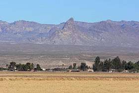
Boundary Cone, a prominent landmark in the western foothills of the Black Mountains, viewed from Mohave Valley
-
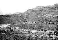
Historic Oatman, AZ, 1921
-
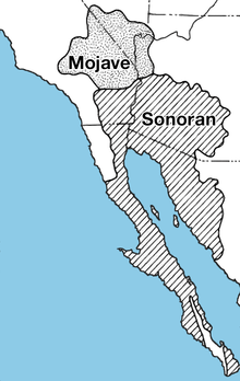
Mojave Desert region
Regional area of the Black Mountains
|
West of Black Mountains
|
East
|
See also
References
- ↑ Mount Perkins, Arizona Road & Recreation Atlas, c 1998, p. 32-33.
- ↑ Mount Perkins, mountainzone
- ↑ Detrital Wash Watershed
- ↑ Sacramento Wash Watershed
External links
Watersheds
- Detrital Wash Watershed
- Havasu-Mohave Lakes Watershed
- Sacramento Wash Watershed, in Sacramento Valley