Kingman, Arizona
| Kingman, Arizona | ||
|---|---|---|
| City | ||
|
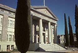
Mohave County Courthouse in Kingman | ||
| ||
| Motto: "The Heart of Historic Route 66" | ||
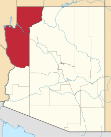
 Location in Mohave County and the State of Arizona | ||
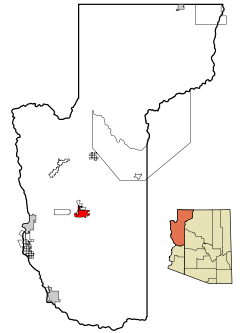
 U.S. Census Map | ||
| Coordinates: 35°12′30″N 114°1′33″W / 35.20833°N 114.02583°WCoordinates: 35°12′30″N 114°1′33″W / 35.20833°N 114.02583°W | ||
| Country | United States | |
| State | Arizona | |
| County | Mohave | |
| Incorporated | 1952 | |
| Government | ||
| • Mayor | Richard Anderson | |
| Area | ||
| • Total | 30 sq mi (77.7 km2) | |
| • Land | 30.0 sq mi (77.6 km2) | |
| • Water | 0.0 sq mi (0.0 km2) | |
| Elevation | 3,333 ft (1,016 m) | |
| Population (2010)[1] | ||
| • Total | 28,068 | |
| • Estimate (2015)[2] | 28,912 | |
| • Density | 669.7/sq mi (258.6/km2) | |
| Time zone | MSTArizona Time (UTC-7) | |
| ZIP codes | 86401, 86402, 86409 | |
| Area code(s) | 928 | |
| FIPS code | 04-37620 | |
| Website | www.cityofkingman.gov | |
Kingman (Huwaalyapay Nyava[3] in the Mojave language) is a city in and the county seat of Mohave County, Arizona, United States. According to the 2010 census, the population of the city is 28,068.[1] The nearby communities of Butler and Golden Valley bring the Kingman area total population to over 66,000. Kingman is located 33 miles (53 km) east of Bullhead City, Arizona and Laughlin, Nevada, 85 miles (137 km) southeast of Las Vegas, Nevada, about 150 miles (240 km) west of Flagstaff, Arizona, about 60 miles (97 km) northeast of Needles, California, about 165 miles (266 km) northwest of Phoenix, Arizona, about 205 miles (330 km) east of Barstow, California and about 315 miles (507 km) northeast of Los Angeles, California.[4]
History
Lt. Edward Fitzgerald Beale, a U.S. Navy officer in the service of the U.S. Army Corps of Topographical Engineers, was ordered by the U.S. War Department to build a federal wagon road across the 35th Parallel. His secondary orders were to test the feasibility of the use of camels as pack animals in the southwestern desert. Beale traveled through the present day Kingman in 1857 surveying the road and in 1859 to build the road. Beale's Wagon Road became part of Highway 66 and Interstate Highway 40. Remnants of the wagon road can still be seen in White Cliffs Canyon in Kingman.
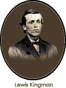
Kingman, Arizona, was founded in 1882, when Arizona was still Arizona Territory. Situated in the Hualapai Valley between the Cerbat and Hualapai mountain ranges, Kingman is known for its very modest beginnings as a simple railroad siding near Beale’s Springs in the Middleton Section along the newly constructed route of the Atlantic and Pacific Railroad. The city of Kingman was named for Lewis Kingman, who surveyed along the Atlantic and Pacific Railroad's right-of-way between Needles, Calif., and Albuquerque, N.M. Lewis Kingman supervised the building of the railroad from Winslow, Ariz. to Beale's Springs, which is near the present location of the town of Kingman.
The Mohave County seat originally was located in Mohave City from 1864 to 1867. The portion of Arizona Territory west of the Colorado River was transferred to Nevada in 1865 after Nevada's statehood, and became part of Lincoln County, Nevada later Clark County, Nevada. The remaining territory of Pah-Ute County became part of Mohave County. Its seat was moved to Hardyville (which is now within Bullhead City) in 1867. The county seat transferred to the mining town of Cerbat in 1873, then to Mineral Park near Chloride in 1877. In 1887, the county seat was moved to Kingman after some period of time without a permanent county seat, the instruments and records of Mohave County government were taken clandestinely from Chloride and moved to Kingman in the middle of the night during this final transfer of the county seat.
During World War II, Kingman was the site of a U.S. Army Air Force (USAAF) airfield. The Kingman Army Airfield was founded at the beginning of WW II as an aerial gunnery training base. It became one of the USAAF's largest, training some 35,000 soldiers and airmen. The airfield and Kingman played a significant role in this important era of America's history. Following the war, the Kingman Airfield served as one of the largest and best-known reclamation sites for obsolete military aircraft.
Postwar, Kingman experienced growth as several major employers moved into the vicinity. In 1953 Kingman was used to detain those men accused of practicing polygamy in the Short Creek raid,[5] which was at the time one of the largest arrests in American history.[6] In 1955, Ford Motor Company established a proving ground (now one of the Chrysler Proving Grounds) in nearby Yucca, Arizona at the former Yucca Army Airfield. Several major new neighborhoods in Kingman were developed to house the skilled workers and professionals employed at the proving ground, as Kingman was the only sizable, developed town within a convenient distance. Likewise, the development of the Duval copper mine near adjacent Chloride, Arizona, and construction of the Mohave Generating Station in nearby Laughlin, Nevada, in 1971 contributed to Kingman's population growth. The location of a General Cable plant at what was to become the Kingman Airport Industrial Park provided a steady employment base as well.
Geography
Kingman is located at 35°12′30″N 114°1′33″W / 35.20833°N 114.02583°W (35.208449, -114.025730),[7] at 3,333 feet (1,016 m) in elevation.
According to the United States Census Bureau, the city has a total area of 30.0 square miles (78 km2), all of it land.
Climate
Kingman sits on the eastern edge of the Mojave Desert, but is located in a "cold semi-arid climate" (Köppen BSk) instead of the desert. The BSk climate type receives slightly more precipitation than the BWh hot desert climate found to the south and west, and the wintertime low temperatures are significantly colder. Kingman's higher elevation and location between the Colorado Plateau and the Lower Colorado River Valley keeps summer high temperatures away from the extremes (115 °F (46 °C) or more) experienced by Phoenix and the Colorado River Valley. The higher elevation also contributes to winter cold and occasional snowfall. Summer daytime highs reach above 90 °F (32 °C) frequently, but rarely exceed 107 °F (42 °C). Summertime lows usually remain between 60 to 70 °F (16 to 21 °C). Winter highs are generally mild, ranging from around 50 to 65 °F (10 to 18 °C), but winter nighttime lows often fall to freezing, with significantly lower temperatures possible. Kingman occasionally receives a dusting of snow in the winter, though it rarely remains on the ground for longer than the mid-to-late morning.
The record low temperature in Kingman was set on January 9, 1937 at 6 °F (−14 °C), and the record high temperature occurred on August 19, 1915, July 16, 1917, and July 3, 1967, at 111 °F (44 °C). The wettest year was 1919 with 21.22 inches (539 mm) and the driest year was 1947 with 3.58 inches (91 mm). The most rainfall in one month was 9.85 inches (250 mm) in September 1939. The most rainfall in 24 hours was 6.03 inches (153 mm) on November 28, 1919. The snowiest year was 1949 with 18.2 inches (0.46 m). The most snowfall in one month was 14.0 inches (0.36 m) in December 1932.[8][9] On December 31, 2014 and January 1, 2015, Kingman received 6.5 inches of snow. The storm was so significant that it was a contributing factor for closing Interstate 40 at the US 93 Junction for 24 hours.
| Climate data for Kingman, Arizona | |||||||||||||
|---|---|---|---|---|---|---|---|---|---|---|---|---|---|
| Month | Jan | Feb | Mar | Apr | May | Jun | Jul | Aug | Sep | Oct | Nov | Dec | Year |
| Record high °F (°C) | 78 (26) |
82 (28) |
90 (32) |
97 (36) |
106 (41) |
110 (43) |
111 (44) |
111 (44) |
108 (42) |
99 (37) |
90 (32) |
77 (25) |
111 (44) |
| Average high °F (°C) | 55.9 (13.3) |
60.0 (15.6) |
65.8 (18.8) |
74.2 (23.4) |
82.7 (28.2) |
92.7 (33.7) |
97.8 (36.6) |
95.3 (35.2) |
90.3 (32.4) |
79.0 (26.1) |
66.5 (19.2) |
56.7 (13.7) |
76.41 (24.68) |
| Average low °F (°C) | 31.1 (−0.5) |
33.6 (0.9) |
36.8 (2.7) |
43.2 (6.2) |
49.7 (9.8) |
58.1 (14.5) |
67.2 (19.6) |
65.5 (18.6) |
58.0 (14.4) |
47.6 (8.7) |
37.8 (3.2) |
32.1 (0.1) |
46.73 (8.18) |
| Record low °F (°C) | 6 (−14) |
9 (−13) |
16 (−9) |
20 (−7) |
29 (−2) |
34 (1) |
45 (7) |
43 (6) |
31 (−1) |
27 (−3) |
13 (−11) |
10 (−12) |
6 (−14) |
| Average precipitation inches (mm) | 1.09 (27.7) |
1.30 (33) |
1.05 (26.7) |
0.66 (16.8) |
0.25 (6.4) |
0.15 (3.8) |
0.90 (22.9) |
1.42 (36.1) |
0.98 (24.9) |
0.66 (16.8) |
0.71 (18) |
1.17 (29.7) |
10.34 (262.8) |
| Average snowfall inches (cm) | 1.3 (3.3) |
0.3 (0.8) |
0.7 (1.8) |
0.1 (0.3) |
0.0 (0) |
0.0 (0) |
0.0 (0) |
0.0 (0) |
0.0 (0) |
0.0 (0) |
0.3 (0.8) |
1.0 (2.5) |
3.7 (9.5) |
| Average precipitation days (≥ 0.01 inch) | 4 | 4 | 4 | 3 | 1 | 1 | 4 | 5 | 3 | 2 | 2 | 4 | 37 |
| Source: Western Regional Climate Center[10] | |||||||||||||
Demographics
| Historical population | |||
|---|---|---|---|
| Census | Pop. | %± | |
| 1890 | 322 | — | |
| 1910 | 900 | — | |
| 1920 | 1,276 | 41.8% | |
| 1930 | 2,275 | 78.3% | |
| 1950 | 3,342 | — | |
| 1960 | 4,525 | 35.4% | |
| 1970 | 7,312 | 61.6% | |
| 1980 | 9,257 | 26.6% | |
| 1990 | 12,722 | 37.4% | |
| 2000 | 20,069 | 57.8% | |
| 2010 | 28,068 | 39.9% | |
| Est. 2015 | 28,912 | [11] | 3.0% |
| U.S. Decennial Census[12] 2014 Estimate[2][13] | |||
As of the census of 2000, there were 20,069 people in all with 7,854 households, and 5,427 families residing in the city. The population density was 669.7 people per square mile (258.5/km²). There were 8,604 housing units at an average density of 287.1 per square mile (110.8/km²). The racial makeup of the city is 82.2% White, .04% Black or African American, 1% Native American, .09% Asian, 0.07% Pacific Islander, 3.41% from other races, and 3.1% from two or more races. 12.2% of the population were Hispanic or Latino of any race.
There were 7,854 households out of which 30.1% had children under the age of 18 living with them, 54.6% were married couples living together, 10.1% had a female householder with no husband present, and 30.9% were non-families. 25.5% of all households were made up of individuals and 11.7% had someone living alone who was 65 years of age or older. The average household size was 2.47 and the average family size was 2.94.
In the city the population was spread out with 25.0% under the age of 18, 7.4% from 18 to 24, 25.6% from 25 to 44, 24.2% from 45 to 64, and 17.8% who were 65 years of age or older. The median age was 40 years. For every 100 females there were 97.5 males. For every 100 females age 18 and over, there were 94.4 males.
The median income for a household in the city was $34,086, and the median income for a family was $41,327. Males had a median income of $32,036 versus $21,134 for females. The per capita income for the city was $17,181. About 8.2% of families and 11.6% of the population were below the poverty line, including 15.3% of those under age 18 and 7.9% of those age 65 or over.
Government and infrastructure
Kingman's city administration consists of the Mayor, Vice-mayor, the City Council, and the City Manager. The current Mayor and Vice-mayor are Richard Anderson and Mark Wimpee Sr. The City Council consists of 5 elected officials - Jen Miles, Mark Wimpee Sr., Larry Carver, Stuart Yocum and Mark Abram. The City Manager is John Dougherty. The City Attorney is Carl Cooper.
The city government also includes boards and commissions that assist the City Council in decision making. They are the:
- Clean City Commission
- Economic Development & Marketing Commission
- Golf Course Advisory Commission
- Historical Preservation Commission
- Municipal Utilities Commission
- Parks and Recreations Commission
- Planning and Zoning Commission
- Transit Advisory Commission
- Tourism Development Commission
- Youth Advisory Commission
- Tri-City Council
Arizona State Prison – Kingman, a privately run prison of the Arizona Department of Corrections, is located in unincorporated Mohave County, Arizona, near Kingman.[14][15]
The United States Department of the Interior Bureau of Land Management has a field office located in Kingman.
Economy
Top employers
According to Kingman's 2014 Comprehensive Annual Financial Report,[16] the top employers in the city are:
| # | Employer | # of Employees |
|---|---|---|
| 1 | Kingman Regional Medical Center | 1,630 |
| 2 | Mohave County | 1,325 |
| 3 | Kingman Unified School District | 985 |
| 4 | Mohave Community College | 700 |
| 5 | American Woodmark | 500 |
| 6 | Walmart | 470 |
| 7 | UniSource Energy Services | 360 |
| 8 | City of Kingman | 332 |
| 9 | State of Arizona | 278 |
| 10 | K Mart | 150 |
| 11 | Petro Stopping Centers | 145 |
| 12 | Proving Grounds Company | 115 |
| 13 | True Value | 90 |
Transportation
Major highways
.svg.png) Interstate 40
Interstate 40 U.S. Route 93
 Arizona State Route 66
 Business Loop 40 and Arizona SR 66 are composed of the remnants of what was
 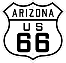 U.S. Route 66.
 Arizona State Route 68 splits from U.S. 93 just west of Kingman, and is the primary link between Kingman and Bullhead City and Laughlin.
 With the completion of the Mike O'Callaghan – Pat Tillman Memorial Bridge, the proposed Interstate 11 would run through Kingman, replacing U.S. 93.
Airport
The Kingman Airport is located nine miles northeast of Kingman on Arizona State Route 66. The airport was originally built as Kingman Army Air Field during World War II, and was home to the Kingman Aerial Gunnery School. After the war, large numbers of USAAF aircraft were stored and dismantled at Kingman. The airport was turned over to Mohave County for civilian use in 1949. Today, the airport has air ambulance and air charter services. The airport continues to be used as a location for long-term aircraft storage due to its suitable large ramp space and a long decommissioned runway. Kingman is a non-towered airport.
Rail
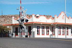
Kingman has passenger rail service at its train station. It is served by the Amtrak Southwest Chief route, with daily service between Los Angeles and Chicago. The small Amtrak station in downtown Kingman is a historically significant building, constructed in Mission Revival Style architecture; however, prior to the establishment of Amtrak in 1971, the structure had fallen into disrepair with the decline of passenger rail service in the U.S. A total renovation of the building was completed in 2010. While still serving as a railroad station, the building is also now home to a model railroad museum.
Kingman also is located on the Southern Transcon route of the BNSF Railway. This is the main transcontinental route between Los Angeles and Chicago, and carries 100 to 150 freight trains per day.
In August 2012 the Kingman Terminal Railroad ( KGTR ) opened at the Kingman Airport Authority and Industrial Park. The KGTR is a short line railroad owned by Patriot Rail. Patriot Rail owns and operates 13 railroads in 13 states across the U.S. The KGTR interchanges with BNSF and delivers to the customers that populate the industrial park.
Education
Kingman has one public school district, one charter school district, and one Christian school. All primary education is split between the public and charter school districts: Kingman Unified School District and Kingman Academy of Learning.
Public schools
Kingman Unified School District (KUSD) consists of 12 schools. These are divided between elementary, middle, and high schools, plus one K-12.[17]
Elementary Schools
- Hualapai Elementary School
- Cerbat Elementary School
- Palo Christi Elementary School (closed for two years for repairs after the 2012–2013 school year[18])
- Black Mountain Elementary School (located in the neighboring town of Golden Valley)
- La Senita Elementary School
- Manzanita Elementary School
- Desert Willow Elementary School
- Kingman Academy of Learning Primary/Intermediate School
Middle Schools
- Golden Valley Middle School
- Kingman Middle School
- White Cliffs Middle School
- Kingman Academy of Learning Middle School
High Schools
- Kingman High School
- Lee Williams High School
- Kingman Academy of Learning High School
K-12
- Mt. Tipton School, a KUSD K-12 school, is located in Dolan Springs, approximately 30 miles northwest of Kingman.
Other schools
- The Kingman Academy of Learning, a charter school, is split into 4 schools: a primary (preschool - 2nd grade), intermediate (3rd - 5th), middle (6th - 8th), and high school (9th - 12th).
- The Emmanuel Christian Academy teaches students from kindergarten to 8th grade.[19]
Postsecondary education
- One of the three main campuses of Mohave Community College, a junior college, is located in Kingman.
- Northern Arizona University has an extension campus located in Kingman.
Kingman Explosion/Doxol Disaster
The Kingman Explosion, also known as the Doxol Disaster or Kingman BLEVE, was a catastrophic boiling liquid expanding vapor explosion (BLEVE) that occurred on July 5, 1973 in Kingman. The explosion occurred during a propane transfer from a Doxol railroad car to a storage tank on the Getz rail siding near Andy Devine Avenue/Route 66.
Firefighters Memorial Park in Kingman is dedicated to those 11 firefighters who died in the BLEVE.
Notable people
- The actor Andy Devine was raised in Kingman, where his family had moved from Flagstaff when he was one year old. His father opened the Beale Hotel here. One of the major streets of Kingman is named "Andy Devine Avenue" and the town holds the annual "Andy Devine Days".
- Michael Fortier, Timothy McVeigh's co-conspirator, lived in Kingman from the age of seven.
- Miki Garcia, model and Playboy magazine's Playmate for the January 1973 issue, was born in Kingman.
- Timothy McVeigh was a resident of Kingman for various periods between 1993 and 1995, including immediately prior to the Oklahoma City bombing.
- Former Boston Red Sox catcher Doug Mirabelli was born in Kingman.
- Actor Will Sasso has been known to stay in Kingman for extended periods, escaping Los Angeles to get some R&R for his mind, body and soul.
- With Arizona being a "neutral" state for the Mafia, and with Kingman's proximity to Las Vegas, members and associates of various La Cosa Nostra organizations -- including Chicago and New York -- have reportedly made Kingman their home over the years, as well as other areas of Mohave County.
- Several members of the rock band The Asphalt currently live in Kingman, including drummer Nick Turner, guitarist Jason Marino and bassist Clifford Hickle.
In popular culture
Celebrities
- Clark Gable and Carole Lombard were married at the rectory of Saint John's Methodist Episcopal Church, during a break in the shooting of Gone with the Wind.[20]
Onscreen
Kingman has been featured as a filming location for several movies and television shows.
In films
- The films Roadhouse 66 and Two-Lane Blacktop were shot in Kingman.
- The movie Management takes place but was not shot in Kingman.
- Scenes from the movie Fear and Loathing in Las Vegas were filmed at the Kingman Airport; in the scene, it is possible to see a clear shot of the Hualapai Mountain.
- Scenes from the 1992 movie Universal Soldier were filmed in the downtown area as well as a local grocery store and at the Kingman Airport.[21]
- Scenes from the 1996 movie Mars Attacks! were filmed in Dolan Springs and Kingman.
In television
- In "Otis", an episode from the television series Prison Break, LJ Burrows is sent to an adult facility in Kingman, Arizona. In a subsequent episode "Buried", LJ is released from the aforementioned facility.
- In "Native Tongue", an episode from the television series "Medium" (NBC: 2005-09; CBS: 2009-2011), Alison has a dream about a man being threatened to be burned alive unless he revels the whereabouts something the killer wants. The man tells the killer that 'it' is near Kingman, where his partner lives. As the story progresses, it is discovered that the man is associated with the Navajo Reservation located 20 E of Kingman.
- In the HBO Series The Sopranos, when Tony Soprano was shot in the beginning of Season 6, he fell into a coma and believed he was involved in a case of mistaken identity with Kevin Finnerty who lived in Kingman, Arizona (see "Join the Club").
- In "The Locomotion Interruption, the season 8 premiere of The Big Bang Theory, Sheldon Cooper finds his belongings stolen at the Kingman, Arizona train station.
In literature and publications
- The town is mentioned in Barbara Kingsolver's novel Pigs in Heaven.[22]
- In the post-apocalyptic novel Warday, Kingman is the "point of entry" to California; the Golden State, spared by the nuclear attacks that hit much of the rest of the country, is strictly guarded by troops, and "illegals" are jailed.
- Pamela Anderson did one of her 1992 Playboy photo shoots at the corner of 4th Street and Andy Devine Avenue (U.S. Route 66), and was brought into the Kingman Police Department for indecent exposure. She was not charged but asked to write a letter of apology.
In music
- The town is mentioned in the lyrics to Bobby Troup's song "Route 66".
Points of interest
- Hualapai Mountain Recreation Area
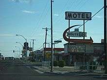
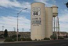
- Kingman is well known for its location on Route 66.
- The city is a gateway to the gambling destinations of Las Vegas and Laughlin, Nevada, as well as the Grand Canyon, California, the Colorado River, Lake Mead National Recreation Area, Lake Mohave, and Lake Havasu.
- Oatman, Arizona, a nearby "ghost town" tourist attraction.
- Keepers of the Wild, a wild animal sanctuary featuring lions and tigers among other animals.[23][24]
- Kingman is the closest city to the Grand Canyon Skywalk, a transparent horseshoe-shaped cantilever bridge and tourist attraction on the edge of the Grand Canyon.
- The Grand Canyon Caverns, one of the largest dry caverns in the United States, is a short drive north and east of Kingman.
References
- 1 2 "American FactFinder". United States Census Bureau. Retrieved 2014-06-19.
- 1 2 "Population Estimates". United States Census Bureau. Retrieved July 11, 2015.
- ↑ Munro, P et al. A Mojave Dictionary Los Angeles: UCLA, 1992
- ↑ "Mohave County - Home". Co.mohave.az.us. Retrieved 2012-01-06.
- ↑ Zoellner, Tom (June 28, 1998), "Polygamy: Throughout its history, Colorado City has been home for those who believe in virtues of plural marriage", The Salt Lake Tribune, p. J1, Archive Article ID: 100F28A4D3D36BEC (NewsBank), archived from the original on 2000-05-05
- ↑ C.R. Waters, Mohave Miner, 1953-08-30.
- ↑ "US Gazetteer files: 2010, 2000, and 1990". United States Census Bureau. 2011-02-12. Retrieved 2011-04-23.
- ↑ "KINGMAN, ARIZONA - Climate Summary". Wrcc.dri.edu. Retrieved 2016-02-14.
- ↑ "KINGMAN #2, ARIZONA - Climate Summary". Wrcc.dri.edu. Retrieved 2016-02-14.
- ↑ "KINGMAN, ARIZONA (024639)". Western Regional Climate Center. Retrieved 2013-03-31.
- ↑ "Annual Estimates of the Resident Population for Incorporated Places: April 1, 2010 to July 1, 2015". Retrieved July 2, 2016.
- ↑ United States Census Bureau. "Census of Population and Housing". Retrieved June 19, 2014.
- ↑ 1950 census figure enumerated prior to incorporation.
- ↑ "Arizona State Prison – Kingman (MTC)". Azcorrections.gov. Retrieved 2016-02-14.
- ↑ "Golden Valley CDP, Arizona." U.S. Census Bureau. Retrieved on August 13, 2010.
- ↑ "CITY OF KINGMAN, ARIZONA : Comprehensive Annual Financial Report : Fiscal Year Ended June 30, 2014". Cityofkingman.gov. Retrieved 2016-02-14.
- ↑ "Kingman Unified School District #20". Kingman Unified School District. Retrieved September 6, 2013.
- ↑ Steele, Kim (April 30, 2013). "Palo Christi Elementary marks 85 years as repairs commence". www.kdminer.com. Kingman Daily Miner. Retrieved September 6, 2013.
- ↑ "Emmanuel Christian Academy Tuition and Fees". Retrieved 23 March 2016.
- ↑ Bartel, Pauline (2014). The Complete Gone With the Wind Trivia Book: The Movie and More (2 ed.). Lanham, Maryland: Taylor Trade Publishing. p. 80. ISBN 9781589798212. Retrieved 22 October 2014.
- ↑ "Universal Soldier (1992) : Filming locations". IMDb.com. Retrieved 2016-02-14.
- ↑ Kingsolver, Barbara (1993). Pigs in Heaven (Paperback). Harper Perennial.
- ↑ https://web.archive.org/web/20111025225758/http://eraz.us/community-calander/thing-to-do-and-sees-in-and-about-kingman. Archived from the original on October 25, 2011. Retrieved October 23, 2011. Missing or empty
|title=(help) - ↑ "Exotic Animal Rescue | Animal Sanctuary Arizona". Keepers of the Wild. Retrieved 2016-02-14.
External links
| Wikimedia Commons has media related to Kingman, Arizona. |
 Kingman travel guide from Wikivoyage
- City of Kingman
- Official website for The Kingman Daily Miner
- History of Medicine in Kingman and Mohave County at the Wayback Machine (archived February 16, 2007)