Lovelock Aerial Gunnery Range
| Lovelock Aerial Gunnery Range | |
| military region | |
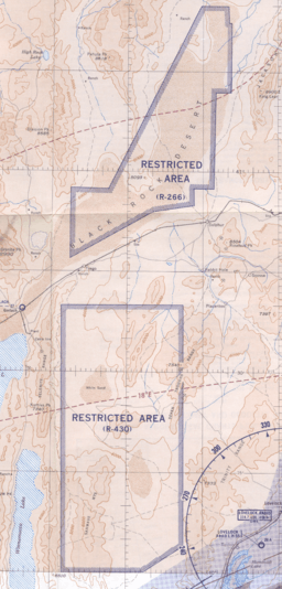 1955 map of "U. S. Prohibited, Restricted, Caution and Warning Areas on Elko Sectional Chart": "Black Rock Desert" (R-266) and "Sahwave Mountains" (R-430) | |
| Country | United States |
|---|---|
| State | Nevada |
| Counties | North: Pershing South: Humboldt |
| Nearest city | Reno |
| Landmark | (NRHP tbd) |
| North area South area |
0 sq mi (0 km2) 0 sq mi (0 km2) |
| Years | 1945-1963 |
Lovelock Aerial Gunnery Range was a World War II facility in two Nevada areas used for "aerial gunnery, strafing, dive bombing [and] rocket fire".[1] By 21 November 1944, the Lovelock Range had been approved by the Secretary of the Navy to be developed for Naval Air Station Fallon,[1] and on 13 January 1945, "Lovelock Air to Air" began[2] when "leased under the Second War Powers Act".[3] By February 1945,[2] land was being acquired[4] for the North Range in the Black Rock Desert which was 1,122 sq mi (2,910 km2) that included 64.4 sq mi (167 km2) of "Patented" (leased private) land.[2] The South Range in the Granite Springs Valley was 2,436 sq mi (6,310 km2), and in March 1945 "1920 Acres more" were added.[2]
The post-war range was reactivated in October 1945 when the United States Navy closed more than 1,563 sq mi (4,050 km2) to the public in the two Lovelock Aerial Gunnery Range regions.[5] The Department of the Interior permit for the Lovelock Range's North Portion was cancelled by a 6 March 1946 "BuDocks ltr", and the Bureau of Yards and Docks was directed to cancel the leases for the South Portion by the Chief of Naval Operations on 7 January 1947 (a lease for "NAAF Lovelock" ended on 1 January 1947).[6]
Black Rock Desert Gunnery Range
The 1942 area of 973 sq mi (2,520 km2) in the Black Rock Desert for World War II USAAF aerial gunnery[5] (Targets 25, 26, 27 in areas 1, 2, 3)[7] was used for a 1949 Navy range of 745 sq mi (1,930 km2) that was reactivated near Sulphur, Nevada.[5] After a 1955 request by congressman Clair Engle,[5] the Black Rock Desert Gunnery Range was closed by 1964.[8]
Sahwave Mountain Air to Air Gunnery Range
In 1958 after the World War II Lovelock South range was "renamed Sahwave Mountain Air to Air Gunnery Range…the 500,000 acres was acquired by…Public Land Order No. 3632. Formal acquisition of the range was completed in August".[9] Used for "only machine gun" fire, the 547,906 acres (856.103 sq mi) "Basic Sahwave air-to-air gunnery range" was in use by October 1958.[10]
On 25 October 1976, after an INS platform failure during night training, Lockheed SR-71A, 61-7965, (Article 2016) was lost near Lovelock (the pilot and RSO ejected safely).[11]
References
- 1 2 Stephens, Albert Lee Jr. (21 November 1944), Enclosure (A): Memorandum for District Public Works Officer (attachment to letter), Enclosure (A),
Churchill Flight Strip…Adjacent to highway between Fallen and Carson City, Nevada, near Lahontan reservoir … The strip is under the jurisdiction of the Public Roads Administration and has been used by the Army in connection with the Reno Army Air Base.
(pdf p. 143 of Archive Summary Report--Findings: Dixie Valley Bombing Target No. 21) - 1 2 3 4 Gunnery Range and Target Areas Released Since WW II - 12th Naval District (Report).
Churchill County East Range
(pdf p. 143 of Archive .Summary Report--Findings: Dixie Valley Bombing Target No. 21) - ↑ Command History: U.S. Naval Auxiliary Air Station Fallon, Nevada; June 10, 1944 - December 31, 1958 (Report). OPNAV Report 5450-5). 1959 [circa].
When World War II started, the Army chose several places in Nevada for the construction of small air fields to be used as part of the western defense program. Some of the places selected were Minden, Winemucca, Lovelock, and Fallon. Army Engineers began the original work here in June of 1942; constructing the first two runways and connecting taxiways. These were the EW (7/25) and the NE-SW (13/31) strips and each was 5200 feet in length. The work was finished in December 1942. The original cost of the project was $464,000. 438,000 was for the runways and $26,000 for lighting. The land was leased to the C.A.A by the county. …this station also has the use of the Churchill Flight Strip (Lahontan Dam) built by the Public Roads Administration. … two large free gunnery areas, on predominantly waste land have been acquired, and requisite rocket bombing and ground-strafing targets have been constructed
(pdf p. 35 of Archives Search Report--Findings: Dixie Valley Bombing Target No. 21. Note: The c. 1959 sentence with "Minden, Winemucca, Lovelock, and Fallon" was subsequently used in edited form in 1973's Welcome Aboard ("Fallon, along with Nevada sites at Minden, Tonopah, Lovelock and Winnemucca") and that edited quotation was used verbatim in the 2002 Archives Search Report, p. 4-1. The 1997 The Economic Evolution of Fallon returned to the originally list's wording, but added "the Civil Aviation Administration and the Army Air Corps began building four airfields" and capitalized "Western Defense Program".) - ↑ "Navy To Use Dixie Valley: Settlers Leaving Gunnery Range". Reno Evening Gazette. June 28, 1945. p. 8. Retrieved 2015-12-22. (pdf p. 161 of Archive Summary Report--Findings: Dixie Valley Bombing Target No. 21)

- 1 2 3 4 Loomis, David (1993). Combat zoning: military land-use planning in Nevada. University of Nevada Press. p. 17. ISBN 9780874171877. Retrieved 2010-04-18.
- ↑ Naval Air Bases, Twelfth Naval District: Status of Facilities (Report). 15 February 1947. (pdf p. 143 of Archive Summary Report--Findings: Dixie Valley Bombing Target No. 21)
- ↑ Archive Search Report: Dixie Valley Bombing Target No. 21 (PDF) (Report).
In 1942 U.S. Army Engineers began construction on the Fallon, Nevada military site along with Nevada sites at Minden, Tonopah, Lovelock and Winnemucca. … World War II Navy pilots at Fallon AAS also used ranges at Black Rock, Sahwave, Lovelock Gunnery Range, Pyramid Lake (torpedo bombing range) and Bravo 19
(in the Blow Sand Mountains). … Area No. 1 Target No. 25 Area No. 2 Target No. 26 Range ( Area No. 3 Target No. 27) (pdf p. 145) - ↑ Lovelock A Inventory Project Report (PDF) (Report). U.S. Army Corps of Engineers - Sacramento District, Formerly Used Defense Sites (FUDS) Program. 1999. Retrieved 2010-04-18.
- ↑ Findings of Fact: Lovelock South Gunnery Range (PDF) (Report). DERP-FUDS PROJECT NO. J09NV1116. Archived from the original (PDF) on 2013-06-23.
- ↑ "Here and There on the Desert: Navy Using Sahwave Range" (PDF). Desert: 33. October 1958.
U.S. Naval Ordnance Test Station's B-Range … N.O.T.S. MOJAVE B-RANGE … Persons wishing to enter the dangerous Slocum Mountain firing area must obtain prior permission from the Security Officer, Naval Ordnance Test Station, China Lake … The B-Range, which has been largely leased land, and territory immediately south of it is included in the Navy's latest land expansion attempt. Total area involved is 180,000 acres. … The Navy claims it needs to extend its boundaries of the B-Range, where guided missiles are being tested, to insure against rockets straying beyond limits of the bombing area. … LOVELOCK — For the first time since the end of World War II the Navy is conducting firing practice over its 547,906-acre Basic Sahwave air-to-air gunnery range. Firing is planned to continue until January. Only machine gun bullets will be fired. The Navy has agreed with the Department of Interior not to shoot rockets, missiles or other flaming ammunition that might set the range on fire.—Lovelock Review-Miner. … Union Oil Company of California's announcement that it was shutting down its multi-million dollar oil shale retort plant near Rifle because of "economic conditions" … The famed El Paso Mine at Cripple Creek has been re-opened—but for a new purpose. The dark recesses of the mine's second level are being used for the cultivation of mushrooms.—S.M.S. Matrix
- ↑ Crickmore, Paul F. (1997). Lockheed's Blackbirds: A-12, YF-12 and SR-71. Wings of Fame. Volume 8. Westport, Connecticut: AIRtime Publishing Inc. p. 92. ISBN 1-880588-23-4.
25 Oct 1967 SR-71A #965 crashed near Lovelock, NV after ANS failure, 2nd SR lost by 9 SRW, USAF Pilot/RSO: Roy St.Martin/ John Carnochan (crew E-18) ok (LSB; SME; LSW)
(quote from "A-12, YF-12A, & SR-71 Timeline of Events")