Blaenllechau
| Blaenllechau | |
| Welsh: Blaenllechau | |
 Blaenllechau post office |
|
 Blaenllechau |
|
| OS grid reference | SS995975 |
|---|---|
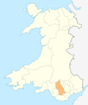
| Principal area | Rhondda Cynon Taff |
| Ceremonial county | Mid Glamorgan |
| Country | Wales |
| Sovereign state | United Kingdom |
| Post town | FERNDALE |
| Postcode district | CF43 |
| Dialling code | 01443 |
| Police | South Wales |
| Fire | South Wales |
| Ambulance | Welsh |
| EU Parliament | Wales |
| UK Parliament | Rhondda |
| Welsh Assembly | Rhondda |
|
|
Coordinates: 51°40′00″N 3°26′46″W / 51.666667°N 3.446111°W
Blaenllechau is a small village located in the Rhondda Fach valley, Rhondda Cynon Taf. Neighbouring villages are Ferndale, Maerdy and Tylorstown. The population of Blaenllechau is less than 1000.
History
Originally a single farm in the Rhondda, in 1857 David Davis and his partners took a mineral rights lease in the area, and went exploring for high quality steam coal. In 1862, after many difficulties, the 4 feet seam was struck 278 yards (254 m) below the farm.
With little in the area, and the need to house workers and their families, the colliery village was developed alongside the workings of Ferndale No.1 pit.[1] Eventually there were two shafts developed, Ferndale No. 1 and Ferndale No. 5, extracting steam coal from a depth of 400 yards (370 m) until 1959, when the entire complex was shut by the National Coal Board.[2] The pit-head workings were still extant in the early 1960s, but have since been demolished and the shafts filled.
The village and its nearest town of Ferndale were served by passenger rail on the Maerdy Branch, which left the mainline of the Taff Vale Railway at Porth. Even under the ownership of the Great Western Railway, the line always found it hard to compete against local bus operators, although passenger services ran regularly from Pontypridd to Maerdy. Passenger services were ceased completely after the Beeching Axe decreased the size of British Railways in the 1960s, and the line operated as a mineral railway until the closure of the last of valley’s collieries, Maerdy, in 1990.
The sites of both railway and colliery have been landscaped. A cricket and sports ground now stand on a slag and spoil tip called the 'Banana tip' because of its shape.
Geography
Blaenllechau is typical of its kind for the topography of the Rhondda Fach Valley (Cwm Rhondda Fach). Three or four rows of stone houses cling to the mountainside.
Blaenllechau is well known for its waterfall.
The village has a park, a community centre and a working men’s club called the Blaenllechau Radical Club, or the ‘Rad’. The village had an infant school, which closed in July 2006 due to a lack of pupils. The pioneer of the coal industry in this part of the Rhondda Fach was David Davis (1797-1866) who had gained his wealth firstly as a tradesman with shops in Hiwaun and Aberdare and later as the owner of steam coal companies in Blaengwawr(Aberdare) and Abercwmboi. He encountered numerous difficulties in his attempts to mine the area around Ferndale. His first attempt to reach the No. 3 Rhondda seam were unsuccessful and the isolated nature of Ferndale at that time meant that all the machinery and materials for the enterprise had to be conveyed from the Aberdare valley by horses, the mountain track being too narrow for carts.
References
External links
| Wikimedia Commons has media related to Blaenllechau. |
- Village history (Glamorgan-Gwent Archaeological Trust)
- www.geograph.co.uk : photos of Blaenllechau and surrounding area
- Welsh Coal Mines - all the pits, all the histories
Villages and towns of the Rhondda Valley | ||
|---|---|---|
| Rhondda Fawr | 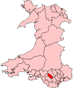 | |
| Rhondda Fach | ||