Blanc-Sablon, Quebec
| Blanc-Sablon | |
|---|---|
| Municipality | |
 | |
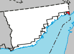 Location within Le Golfe-du-Saint-Laurent RCM. | |
 Blanc-Sablon  Blanc-Sablon  Blanc-Sablon Location in Côte-Nord Region of Quebec. | |
| Coordinates: 51°25′N 57°08′W / 51.417°N 57.133°WCoordinates: 51°25′N 57°08′W / 51.417°N 57.133°W[1] | |
| Country |
|
| Province |
|
| Region | Côte-Nord |
| RCM | Le Golfe-du-Saint-Laurent |
| Settled | 19th century |
| Constituted | January 1, 1990 |
| Government[2] | |
| • Mayor | Armand Joncas |
| • Federal riding | Manicouagan |
| • Prov. riding | Duplessis |
| Area[2][3] | |
| • Total | 376.50 km2 (145.37 sq mi) |
| • Land | 247.63 km2 (95.61 sq mi) |
| Elevation | 2 m (7 ft) |
| Population (2011)[3] | |
| • Total | 1,118 |
| • Density | 4.5/km2 (12/sq mi) |
| • Pop 2006-2011 |
|
| • Dwellings | 508 |
| Time zone | AST (UTC-4) |
| Postal code(s) | G0G 1W0 |
| Area code(s) | 418 and 581 |
| Highways |
|
| GNBC Code | EOACK |
| NTS Map | 012P06 |
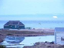
Blanc-Sablon is the easternmost community in Le Golfe-du-Saint-Laurent Regional County Municipality, in the province of Quebec, Canada. With a population of 1,118 inhabitants,[3] it is the most populous community in the county municipality.
Geography
Blanc-Sablon is located on Blanc-Sablon Bay between the municipalities of Côte-Nord-du-Golfe-du-Saint-Laurent, Quebec and L'Anse-au-Clair, Labrador.
Blanc-Sablon is located on the north coast of the Gulf of Saint Lawrence near the entrance of the Strait of Belle Isle. Two significant bays, Brador and Blanc-Sablon, mark its shores and the headland that separates these bays are dominated by Mont Parent, a 100-metre (328 ft) high flat-topped hill named after Martin Parent, a local fisherman in the middle of the 19th century.[4]
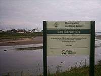
The estuary of the Brador River and Blanc-Sablon River has a lagoon designated barachois, separated from the sea by a sand or gravel. Seawater enters at high tide.
Facing the village of Blanc-Sablon, several islands are dotting the bay, and also in Brador Bay, forming the archipelago of Blanc-Sablon, including: Ile au Bois, Long, Basin and islands Parrots and Greenly housing the Bird Sanctuary of Brador Bay.
The municipality of Blanc-Sablon has several spikes protruding into the Gulf of St. Lawrence (listed from east to west): pointe Saint-Charles, pointe à Morel, pointe Lazy, tip "à la chasse", pointe "à la Barque", cap Crow and tip Jones.
Accessibility
Ferry services
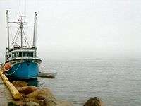
Being at the eastern end of the Côte-Nord region, Blanc-Sablon is serviced by a ferry service for the communities along the north shore of the Gulf of St. Lawrence, connecting with the coastal communities of [5]Saint-Augustin, Gros-Mécatina, Tête-à-la-Baleine, Harrington Harbour, La Romaine and Kegashka, as well as Anticosti Island at Port-Menier. This service is funded by the Government of Quebec.[6] The ferry service mainly serves to fill the gap in Route 138, which remains unbuilt between Kegaska and Old Fort (in Bonne-Espérance).
Blanc-Sablon is also the northern terminus of the MV Apollo, a ferry service across the Strait of Belle Isle to the island of Newfoundland, mainly serving as a connection with nearby Labrador.[7] This ferry service is funded entirely by the government of Newfoundland and Labrador and connects with a southern terminus at St. Barbe on Newfoundland Island's Great Northern Peninsula. This 28 km (17 mi)-long ferry service is in operation from March to January.
Road access
So far, the Municipality of Blanc-Sablon is inaccessible directly to the rest of the Quebec road network. From the west, Route 138 is built up to the village of Kegashka; then following a 425 km (264 mi) gap, a 69 km (43 mi) segment restarts at the village of Old Fort to Blanc-Sablon. To connect the rest of Quebec from Blanc-Sablon, a traveller can take the 1,128 km (701 mi) Trans-Labrador Highway (Route 510) that connects Wabush on the border of Labrador and Quebec; then Route 389 of 594 km (369 mi) connects Wabush and Baie-Comeau to Quebec, passing at the east side of Manicouagan Reservoir. This trip by the north (between Baie-Comeau and Blanc-Sablon) is 1,722 km (1,070 mi). Once Route 138 is completed, the road distance between Baie-Comeau and Blanc-Sablon is estimated to be between 1,045 km (649 mi) to 1,067 km (663 mi); thereby reducing the distance of about 38%.
Annually, the Government of Quebec invests for the extension of Route 138 to Blanc-Sablon.
Air travel
The Lourdes-de-Blanc-Sablon Airport provides scheduled air service to Blanc-Sablon.
History
The place was already known to early European explorers who may have named it after the fine white sand of the eponymous bay (blanc means "white", whereas sablon is the diminutive form of sable meaning "sand"). Or it may be named after Blancs-Sablons Cove in Saint-Malo, home town of Jacques Cartier, who landed at the place in 1534 and set up a cross near the current site of Lourdes-de-Blanc-Sablon.[1]
During the 16th and 17th centuries, Basque and Portuguese fishermen seasonally frequented the area. In 1704, Augustin Le Gardeur de Courtemanche, landlord of the lower Côte-Nord at that time, built Fort Pontchartrain at the current location of Brador. Permanent settlement did not begin until the 19th century with the arrival of French-Canadians, Acadians, and Jersey settlers. In 1858, the Mission of Longue-Pointe-de-Blanc-Sablon was established and took the name Lourdes-de-Blanc-Sablon or Notre-Dame-de-Lourdes at the end of 19th century. In 1884, the post office opened.[1][8]
The area was first incorporated in 1963 as part of the Municipality of Côte-Nord-du-Golfe-Saint-Laurent, but separated on January 1, 1990, and became the Municipality of Blanc-Sablon.[1]
Fifty hectares of land in Blanc-Sablon were designated a National Historic Site of Canada in 2007, as they contain over 60 archaeological sites relating to 9000 years of human occupation, including the Archaic, Dorset and European periods.[9]
In August 2014, Blanc-Sablon mayor Armand Joncas expressed his personal discontent over neglect of the Basse-Côte-Nord area by the Quebec government, and discussed the secession of the Basse-Côte-Nord from Quebec to join the province of Newfoundland and Labrador, even though the mayor does not have any political or judicial powers to do so. Joncas cited a lack of a continuous road network to Quebec, isolation and lack of interest from the Quebec government and close logistics and cultural identity with the people of Labrador as his reasons.[10]
Communities
The municipality includes three villages: Blanc-Sablon, Lourdes-de-Blanc-Sablon, and Brador Bay.
Lourdes-de-Blanc-Sablon
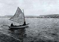
Lourdes-de-Blanc-Sablon (51°24′41″N 57°12′11″W / 51.41139°N 57.20306°W) is the largest community in the municipality, and is located on the headland that separates Brador Bay from Blanc-Sablon Bay. It was originally known as Longue-Pointe (Long Point) until the beginning of the 20th century. It has a small natural harbour, and long depended on the fishing business.[11]
Brador
Brador or Brador Bay (51°27′40″N 57°14′44″W / 51.46111°N 57.24556°W) is on the eastern shore of the namesake bay, 7 kilometers (4.3 mi) north of the village of Lourdes-de-Blanc-Sablon. While known in the 18th century as Fort Pontchartrain and Phélipeaux Bay, its current name is the shortened form of Labrador. In French, the syllable la is a definite article, and in documents from the 17th and 18th century, this syllable was considered as such and separated from the rest of the name. François Martel de Brouague, the King's Commander of this region from 1714 to 1760, referred to this location as: "A la Baye de Phélipeaux, coste de la Brador" ("At the Bay of Phélipeaux, coast of the Brador").[12]
Demographics
Population
| Canada census – Blanc-Sablon, Quebec community profile | |||
|---|---|---|---|
| 2011 | 2006 | 2001 | |
| Population: | 1,118 (-11.5% from 2006) | 1,263 (+5.2% from 2001) | 1,201 (-3.8% from 1996) |
| Land area: | 247.63 km2 (95.61 sq mi) | 247.63 km2 (95.61 sq mi) | 247.63 km2 (95.61 sq mi) |
| Population density: | 4.5/km2 (12/sq mi) | 5.1/km2 (13/sq mi) | 4.8/km2 (12/sq mi) |
| Median age: | 43.5 (M: 43.7, F: 43.4) | 37.9 (M: 37.1, F: 38.7) | 35.4 (M: 36.1, F: 34.8) |
| Total private dwellings: | 508 | 482 | 454 |
| Median household income: | $.N/A | $50,817 | $47,124 |
| Notes: 2011 income data for this area has been suppressed for data quality or confidentiality reasons. – References: 2011[3] 2006[13] 2001[14] | |||
| Historical Census Data - Blanc-Sablon, Quebec[15] | ||||||||||||||||||||||||||||||||||
|---|---|---|---|---|---|---|---|---|---|---|---|---|---|---|---|---|---|---|---|---|---|---|---|---|---|---|---|---|---|---|---|---|---|---|
|
|
|
|
| ||||||||||||||||||||||||||||||
Language
| Canada Census Mother Tongue - Blanc-Sablon, Quebec[15] | ||||||||||||||||||
|---|---|---|---|---|---|---|---|---|---|---|---|---|---|---|---|---|---|---|
| Census | Total | French |
English |
French & English |
Other | |||||||||||||
| Year | Responses | Count | Trend | Pop % | Count | Trend | Pop % | Count | Trend | Pop % | Count | Trend | Pop % | |||||
| 2011 |
1,080 |
315 | |
29.17% | 740 | |
68.52% | 20 | |
1.85% | 5 | |
0.46% | |||||
| 2006 |
1,245 |
330 | |
26.51% | 880 | |
70.68% | 35 | |
2.81% | 0 | |
0.00% | |||||
| 2001 |
1,185 |
395 | |
33.33% | 740 | |
62.45% | 50 | |
4.22% | 0 | |
0.00% | |||||
| 1996 |
1,240 |
350 | n/a | 28.23% | 855 | n/a | 68.95% | 35 | n/a | 2.82% | 0 | n/a | 0.00% | |||||
Climate
Blanc-Sablon experiences a subarctic climate (Köppen climate classification Dfc).
| Climate data for Blanc-Sablon Airport (1981−2010) | |||||||||||||
|---|---|---|---|---|---|---|---|---|---|---|---|---|---|
| Month | Jan | Feb | Mar | Apr | May | Jun | Jul | Aug | Sep | Oct | Nov | Dec | Year |
| Record high °C (°F) | 9.1 (48.4) |
8.3 (46.9) |
8.1 (46.6) |
18.6 (65.5) |
20.5 (68.9) |
26.0 (78.8) |
27.1 (80.8) |
28.1 (82.6) |
23.3 (73.9) |
16.2 (61.2) |
16.2 (61.2) |
7.8 (46) |
28.1 (82.6) |
| Average high °C (°F) | −7.7 (18.1) |
−7.4 (18.7) |
−3.0 (26.6) |
2.5 (36.5) |
7.9 (46.2) |
12.3 (54.1) |
15.7 (60.3) |
16.6 (61.9) |
12.9 (55.2) |
7.1 (44.8) |
2.1 (35.8) |
−3.8 (25.2) |
4.6 (40.3) |
| Daily mean °C (°F) | −12.7 (9.1) |
−12 (10) |
−7.3 (18.9) |
−1.0 (30.2) |
3.8 (38.8) |
8.3 (46.9) |
12.0 (53.6) |
12.8 (55) |
9.0 (48.2) |
3.6 (38.5) |
−1.5 (29.3) |
−8.1 (17.4) |
0.6 (33.1) |
| Average low °C (°F) | −17.5 (0.5) |
−16.5 (2.3) |
−11.4 (11.5) |
−4.4 (24.1) |
−0.3 (31.5) |
4.2 (39.6) |
8.1 (46.6) |
9.0 (48.2) |
5.0 (41) |
0.2 (32.4) |
−5.1 (22.8) |
−12.4 (9.7) |
−3.4 (25.9) |
| Record low °C (°F) | −32.3 (−26.1) |
−34.1 (−29.4) |
−32.5 (−26.5) |
−23.0 (−9.4) |
−11.1 (12) |
−3.6 (25.5) |
0.0 (32) |
1.8 (35.2) |
−4.8 (23.4) |
−10.4 (13.3) |
−18.9 (−2) |
−30.2 (−22.4) |
−34.1 (−29.4) |
| Average precipitation mm (inches) | 97.2 (3.827) |
83.8 (3.299) |
80.1 (3.154) |
49.9 (1.965) |
69.4 (2.732) |
92.0 (3.622) |
102.0 (4.016) |
96.3 (3.791) |
88.8 (3.496) |
87.8 (3.457) |
74.9 (2.949) |
99.6 (3.921) |
1,021.7 (40.224) |
| Average rainfall mm (inches) | 11.8 (0.465) |
7.9 (0.311) |
11.5 (0.453) |
20.5 (0.807) |
62.0 (2.441) |
91.4 (3.598) |
101.9 (4.012) |
96.3 (3.791) |
88.8 (3.496) |
81.9 (3.224) |
48.0 (1.89) |
24.1 (0.949) |
646.0 (25.433) |
| Average snowfall cm (inches) | 85.4 (33.62) |
75.7 (29.8) |
68.6 (27.01) |
29.1 (11.46) |
7.4 (2.91) |
0.66 (0.26) |
0.02 (0.008) |
0.0 (0) |
0.03 (0.012) |
6.0 (2.36) |
26.9 (10.59) |
75.5 (29.72) |
375.3 (147.76) |
| Average precipitation days (≥ 0.2 mm) | 17.5 | 16.9 | 17.0 | 13.9 | 15.1 | 16.0 | 17.4 | 15.1 | 14.5 | 15.5 | 15.8 | 17.9 | 192.7 |
| Average rainy days (≥ 0.2 mm) | 2.8 | 2.4 | 4.5 | 7.3 | 13.2 | 16.0 | 17.4 | 15.1 | 14.5 | 14.5 | 9.8 | 5.2 | 122.5 |
| Average snowy days (≥ 0.2 cm) | 16.5 | 15.9 | 15.1 | 8.7 | 2.9 | 0.32 | 0.04 | 0.0 | 0.04 | 2.3 | 8.6 | 15.6 | 86.1 |
| Mean monthly sunshine hours | 93.9 | 106.7 | 111.7 | 137.6 | 157.5 | 165.3 | 141.9 | 159.0 | 128.9 | 106.2 | 85.1 | 75.8 | 1,469.4 |
| Percent possible sunshine | 36.0 | 37.9 | 30.4 | 33.1 | 32.6 | 33.3 | 28.4 | 35.2 | 33.9 | 32.0 | 31.8 | 30.8 | 32.9 |
| Source: Environment Canada[16] | |||||||||||||
See also
Related articles
- Côte-Nord (North-Shore), administrative region
- Gulf of Saint Lawrence
- Strait of Belle Isle
- Brador River
- Blanc-Sablon River
- Blanc-Sablon Bay
- Border between Quebec and Newfoundland-and-Labrador
- Lourdes-de-Blanc-Sablon Airport
- List of municipalities in Quebec
References
- 1 2 3 4 "Blanc-Sablon (Municipalité)" (in French). Commission de toponymie du Québec. Retrieved 2010-09-30.
- 1 2 "Blanc-Sablon". Répertoire des municipalités (in French). Gouvernement du Québec, Ministère des Affaires municipales, des Régions et de l'Occupation du territoire. Retrieved 2010-09-29.
- 1 2 3 4 "Blanc-Sablon census profile". 2011 Census of Population. Statistics Canada. Retrieved 2012-04-04.
- ↑ "Mont Parent (colline)" (in French). Commission de toponymie du Québec. Retrieved 2010-09-30.
- ↑ Nordik Express
- ↑ by car and ferry
- ↑ Ford
- ↑ "Discover the region > Our villages > Blanc Sablon". Tourism Lower North Shore. Retrieved 2010-09-30.
- ↑ Blanc-Sablon. Canadian Register of Historic Places. Retrieved 5 March 2012.
- ↑ "Blanc Sablon wants to leave Quebec, join N.L.". http://www.cbc.ca/. Canadian Broadcasting Corporation. Retrieved 20 August 2014. External link in
|website=(help) - ↑ "Lourdes-de-Blanc-Sablon (village)" (in French). Commission de toponymie du Québec. Retrieved 2010-09-30.
- ↑ "Brador (hameau)" (in French). Commission de toponymie du Québec. Retrieved 2010-09-30.
- ↑ "2006 Community Profiles". Canada 2006 Census. Statistics Canada. March 30, 2011. Retrieved 2012-04-04.
- ↑ "2001 Community Profiles". Canada 2001 Census. Statistics Canada. February 17, 2012. Retrieved 2012-04-04.
- 1 2 Statistics Canada: 1996, 2001, 2006, 2011 census
- ↑ "Blanc–Sablon A". Canadian Climate Normals 1981–2010. Environment Canada. Retrieved October 6, 2013.
External links
| Wikimedia Commons has media related to Blanc-Sablon, Quebec. |
 |
Petit-Mécatina | Div. No. 10 Subd. A (NL) | | |
| Bonne-Espérance, Côte-Nord-du-Golfe-du-St-Laurent | |
L'Anse-au-Clair (NL) | ||
| ||||
| | ||||
| Gulf of Saint Lawrence |
| Municipalities | |
|---|---|
| Unorganized Territories | |
| Native reserves (Unassociated with RCM) | |
| |