Blennerhassett Island Bridge
| Blennerhassett Island Bridge | |
|---|---|
 | |
| Coordinates | 39°16′36″N 81°38′49″W / 39.27667°N 81.64694°WCoordinates: 39°16′36″N 81°38′49″W / 39.27667°N 81.64694°W |
| Carries |
4 lanes of |
| Crosses | Ohio River |
| Locale | Belpre Township, Washington County, Ohio and Washington, West Virginia |
| Maintained by | West Virginia Division of Highways |
| Characteristics | |
| Design | Network Arch Bridge |
| Total length | 4,009 feet (1,222 m) |
| Width | 107 feet (33 m) |
| Longest span | 878 feet (268 m) |
| Clearance below | 76 feet (23 m) |
| History | |
| Opened | June 13, 2008 |
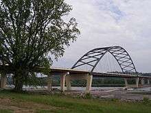
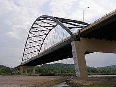
Blennerhassett Island Bridge opened to traffic June 13, 2008. The bridge is a Network Arch Bridge constructed[1] at a cost of $120 million over the Ohio River between Belpre Township, Washington County, Ohio and Washington, West Virginia in the United States. Construction of the bridge was completed by the Walsh Construction Company of Chicago.[2]
The completion of the span, which carries U.S. Route 50, completed Corridor D between Interstate 275 east of Cincinnati to Interstate 79 at Clarksburg, West Virginia. Corridor D is a part of the Appalachian Development Highway System.[2]
Details
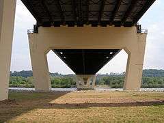
The bridge travels over the Ohio River and the historic Blennerhassett Island. The bridge is wholly owned by WVDOT while only the approach ramps on the Ohio side are owned by ODOT .
Photo gallery


References
- ↑ Parkersburg News. "Bridge Nears Completion". Retrieved 2008-04-16.
- 1 2 GoBridges.com. "Innovative tied-arch steel bridge to span Ohio River". Archived from the original on October 7, 2007. Retrieved 2015-12-08.
External links
- Blennerhassett Island Bridge (US 50) at Bridges & Tunnels
- Blennerhassett Island Bridge article at GoBridges
- Construction Photos at Gribblenation
- E.L. Robinson Design Team of Blennerhassett Island Bridge
- Structural Technical Specs of the Blennerhassett Island Bridge
| Crossings of the Ohio River | ||||
|---|---|---|---|---|
| ||||