Blockade Strategy Board
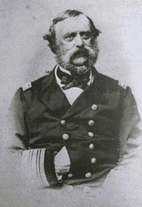
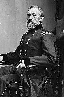
The Blockade Strategy Board of the American Civil War, also known variously as the Commission of Conference or as the Du Pont Board, was a group of four men, meeting in the summer of 1861 at the request of the Navy Department, who laid out a preliminary strategy for enforcing the blockade of seceding states that had been proclaimed by President Abraham Lincoln. Although the board reported to the Navy Department, only half of its members were sailors. These were Captain Samuel Francis Du Pont, who acted as chairman, and Commander Charles Henry Davis. The other two were Major John Gross Barnard of the US Army and Alexander Dallas Bache of the US Coast Survey and the Smithsonian Institution. The board considered the entire coast held by the Confederate States of America, and recommended how best to complete the blockade. Their reports for the Atlantic seaboard were used, with modifications, to direct the early course of the naval war. Their analysis of the Gulf Coast was not so successful, largely because the detailed oceanographic knowledge that marked the Atlantic reports was not available for the Gulf.
Origin
Fort Sumter, in Charleston Harbor, was bombarded on 12 April 1861, thereby initiating the American Civil War. Following the outbreak of hostilities, on 19 April President Lincoln proclaimed a blockade of all ports in the states that had seceded from the Union at that time; later, after Virginia and North Carolina also joined the Confederacy, his proclamation was modified to include their coastlines as well.[1] The blockade, which existed only on paper at this time, became an integral part of the plan to persuade the seceded states to return to the Union that was proposed by General in Chief Winfield Scott. Scott's so-called Anaconda Plan was not formally adopted as an outline strategy to guide the conduct of the war, but the blockade was enforced to the limit of ability of the US Navy as long as the conflict lasted.

At the start, the Navy was woefully inadequate to the task of blockading the 3000 miles (4800 km) of Southern shoreline.[2] It had only 90 ships of all types, and only 42 that were powered by steam. A frenzied program of shipbuilding and conversions of existing merchant vessels increased the number to 671 by the end of the war,[3] but as they came into service, their assignments had to be prioritized.
The person in Lincoln's cabinet most concerned with rationalizing the blockade was Secretary of the Treasury Salmon P. Chase. Treasury's Revenue Cutter Service was the agency most familiar with the nation's ports, and the knowledge of harbor bottoms held by its Coast Survey would be needed by the naval commanders who patrolled their waters. He persuaded Secretary of the Navy Gideon Welles to set up a commission to study the entire Southern coast, and on 25 June 1861 Welles issued the necessary orders to Captain (later Rear Admiral) Samuel Francis Du Pont. At the same time, he ordered Commander (later Rear Admiral) Charles Henry Davis to the board to serve as secretary, and requested that Army Major (later Major General) John G. Barnard, chief of the Army Corps of Engineers, and Alexander D. Bache, Superintendent of the Coast Survey, lend their services.[4] Other persons gave advice, but all reports issued by the commission were signed only by these four.
The reports

The board delivered its first report, dealing with a southern anchor for the Atlantic blockade, on 5 July. It continued to issue reports throughout the summer. These have been published as parts of the Official Records. Identified by their dates, they are:
- 5 July 1861 — ORN I, volume 12, pages 195–198.
- Deals with Fernandina, Florida and its harbor. Recommends seizing it as the southern anchor to the Atlantic blockading line.
- 13 July 1861 — ORA I, volume 53, pages 67–73.
- Considers the South Carolina coast, particularly Bull's Bay, St. Helena Sound, and Port Royal Sound. Recommends seizure and occupation of at least one.
- 16 July 1861 — ORN I, volume 12, pages 198–201.
- Recommends dividing the Atlantic Blockading Squadron in two, to be separated at Cape Romain in South Carolina. Suggests ways to complete blockade between Cape Henry and Cape Romain.
- 26 July 1861 — ORN I, volume 12, pages 201–206.
- Deals with the parts of the Atlantic blockade not covered in the reports of 13 and 16 July.
- 9 August 1861 — ORN I, volume 16, pages 618–630.
- Distinguishes six regions of the Gulf coast, and restricts recommendations to the sections covering New Orleans and Mobile. Suggests that Ship Island be captured as a staging ground for operations against either or both.
- 3 September 1861 — ORN I, volume 16, pages 651–655.
- Deals with Gulf coast other than the parts not considered in report of 9 August.
- 19 September 1861 — ORN I, volume 16, pages 680–681.
- Considers Ship Island and the lower Mississippi River in greater detail than report of 9 August.
- 5 July 1861 — ORN I, volume 12, pages 195–198.
Effect
The recommendations of the board for the Atlantic blockade were mostly accepted, with modifications, by the Lincoln administration. The capture of Fernandina, proposed as the initial offensive action of the Union Navy, was postponed until after the capture of Hatteras Island and Port Royal. The suggestion that Hatteras Inlet be blocked up was overruled by Flag Officer Silas Stringham and Brig. General Benjamin F. Butler, the men who led the expedition.[5] (The board had anticipated that its recommendations would not be followed to the letter. In their report, they included the statement that "These plans may undergo some modification in the hands of the person to whom their execution shall be intrusted.")[6]
The capture of Port Royal Sound also represented a divergence from the board's original plan. They had stated a preference for an attack on St. Helena Sound, which was nearer to Charleston and also would have been harder for the Rebels to defend. The natural advantages of Port Royal were so great, however, that the administration chose to take it. Perhaps ironically, Captain (by then Flag Officer) Du Pont was selected to lead the naval contingent in the expedition against the harbor.[7]
The Gulf blockade diverged much further from board plans for several reasons. One of the most important is the lack of knowledge of the Gulf coast compared with the Atlantic. The hydrography was so imperfectly known that one of the board's more emphatic recommendations was that a Coast Survey vessel should be attached to each blockading squadron.[8] (This recommendation was accepted. The Coast Survey proved to be quite useful throughout the war.)
Although Ship Island was taken in accord with the report of 9 August, the Navy Department used it as the staging ground for David G. Farragut's assault on and capture of New Orleans. The board had opposed any immediate move up the Mississippi River, not because it would be undesirable, but because they believed that it could not be done with the weapons at hand.[9]
The blockade of the southern extreme of the Texas coast also did not conform to board expectations. The problem there was that the port at Brownsville, at the mouth of the Rio Grande, also served the Mexican community of Matamoros. The international problems associated with the blockade there were exacerbated by the rebellion against the Emperor Maximilian going on in Mexico at the time.[10]
Conclusion
Although it may appear that the Blockade Strategy Board had only a minimal effect on the war, it nevertheless deserves respect because it was the first effort by the United States to conduct a war by rational principles, rather than simply reacting to events. As the armed forces did not have an Office of Naval Operations or a General Staff at the time, it served as a rudimentary surrogate. As such, it was an important forerunner of the present-day staff system.
Notes
Abbreviations used in these notes:
- ORA (Official records, armies): War of the Rebellion: a compilation of the official records of the Union and Confederate Armies.
- ORN (Official records, navies): Official records of the Union and Confederate Navies in the War of the Rebellion.
- ↑ Civil War naval chronology, 1861–1865, pp. I-9, I-12.
- ↑ The length of the blockade is at best approximate. Some parts of the seceded states were retained by the Union (Fort Monroe in Virginia, Fort Zachary Taylor at Key West, and Fort Pickens at Pensacola). Other parts of the coast, such as most of southern Florida, were too far removed from the centers of the war to be useful as ports.
- ↑ Tucker, Blue and Gray Navies, p. 1.
- ↑ Reed, Combined operations, p. 7; ORN I, v. 12, p. 195.
- ↑ Reed, Combined operations,, pp. 12–21.
- ↑ ORN I, v. 12, pp. 198–201.
- ↑ Browning, Success is all that was expected, pp. 23–41.
- ↑ ORN I, v. 16, p. 655.
- ↑ ORN I, volume 16, pages 618–630.
- ↑ Wise, Lifeline of the Confederacy, pp. 183–186.
References
- Official records of the Union and Confederate Navies in the War of the Rebellion. Series I: 27 volumes. Series II: 3 volumes. Washington: Government Printing Office, 1894-1922.
- The War of the Rebellion: A compilation of the official records of the Union and Confederate Armies. Series I: 53 volumes. Series II: 8 volumes. Series III: 5 volumes. Series IV: 4 volumes. Washington: Government Printing Office, 1886-1901.
- United States Navy Department, Naval History Division, Civil War naval chronology, 1861–1865. Government Printing Office, 1971.
- Browning, Robert M., Success is all that was expected : the South Atlantic blockading squadron during the Civil War. Washington, D.C. : Brassey’s, 2002. ISBN 1-57488-514-6
- Reed, Rowena, Combined operations in the Civil War. United States Naval Institute, 1978. ISBN 0-87021-122-6
- Tucker, Spencer C., Blue and Gray Navies; the Civil War afloat. Naval Institute, 2006. ISBN 1-59114-882-0
- Wise, Stephen R., Lifeline of the Confederacy: blockade running during the Civil War. University of South Carolina, 1988.